TopoQuest Logo
Do you find TopoQuest useful?
Help keep TopoQuest running and adding new maps/features by donating!
Bitcoin:  19c7KJd3qBynnjoSw5npx9KScwjBe4ifkT
Litecoin:  LXs6TkuXGGXo1vDsWCkWVdjQX94eUKd6ui
Home View Maps Find Maps Find Places Resources & Links


Rowan Mills, North Carolina Topographic Map

USGS Map Title: Rowan Mills, NC
USGS Map MRC: 35080F5
DRG (GeoTIFF) Download: o35080f5.tif


Neighboring USGS Topographic Map Quads:


  Cool Springs, NC  
35080G6
 

  Cooleemee, NC  
35080G5
 

  Churchland, NC  
35080G4
 

  Cleveland, NC  
35080F6
 

  Rowan Mills, NC  
35080F5
 

  Salisbury, NC  
35080F4
 

  Enochville, NC  
35080E6
 

  China Grove, NC  
35080E5
 

  Rockwell, NC  
35080E4


Map MRC Location:

N36°
W81°
N36°
W80°
H8 H7 H6 H5 H4 H3 H2 H1
G8 G7 G6 G5 G4 G3 G2 G1
F8 F7 F6 F5 F4 F3 F2 F1
E8 E7 E6 E5 E4 E3 E2 E1
D8 D7 D6 D5 D4 D3 D2 D1
C8 C7 C6 C5 C4 C3 C2 C1
B8 B7 B6 B5 B4 B3 B2 B1
A8 A7 A6 A5 A4 A3 A2 A1
N35°
W81°
N35°
W80°

Rowan Mills, NC USGS 1:24K Topographic Map Preview:
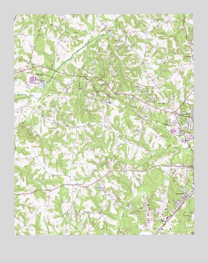
Rowan Mills, NC USGS Topographic Map
Click on map above to begin viewing in our Map Viewer.

This topographic map contains these locations and features:
Feature Name Type Latitude Longitude GNIS ID View Map
Army National Guard Crash and RescueBuildingN35.6481°W80.5233°2639608View Map
Beaverdam CreekStreamN35.7368°W80.5676°980838View Map
Calvary ChurchChurchN35.6888°W80.5956°982448View Map
Dobbins (historical)Populated PlaceN35.7160°W80.5820°1001820View Map
Draft BranchStreamN35.6732°W80.5051°984324View Map
Enon ChurchChurchN35.7088°W80.5270°984808View Map
Fiber LakeReservoirN35.7089°W80.6145°999278View Map
Fiber Lake DamDamN35.7085°W80.6148°999279View Map
Franklin Township Volunteer Fire Department Station 56BuildingN35.7115°W80.5607°2639797View Map
Frohock Mill (historical)Populated PlaceN35.6571°W80.5170°1001837View Map
Gays ChapelChurchN35.7357°W80.5515°985616View Map
Gospel Light ChurchChurchN35.6404°W80.5331°985859View Map
Henderson Grove ChurchChurchN35.6351°W80.5017°986613View Map
Hendrick EstatesPopulated PlaceN35.6982°W80.5320°1001845View Map
Holly ParkPopulated PlaceN35.6974°W80.5201°1001848View Map
Hurley Elementary SchoolSchoolN35.7001°W80.5590°1024833View Map
Isenburg Elementary SchoolSchoolN35.7021°W80.5042°1001850View Map
Kizer Elementary SchoolSchoolN35.6460°W80.5073°1001856View Map
Lincoln HeightsPopulated PlaceN35.6543°W80.5023°1001860View Map
Little CreekStreamN35.6285°W80.5542°988608View Map
Locke Township Fire Department Station 61BuildingN35.6642°W80.5150°2639452View Map
Locke Township Fire Department Station 62BuildingN35.6536°W80.5872°2639445View Map
LockelandPopulated PlaceN35.6649°W80.5128°1001863View Map
Macedonia ChurchChurchN35.7043°W80.5395°989190View Map
Mid-Carolina MallLocaleN35.6932°W80.5151°1001870View Map
Mid-Carolina Regional AirportAirportN35.6479°W80.5219°997955View Map
Milford HillsPopulated PlaceN35.6893°W80.5034°1001871View Map
Milford KnollPopulated PlaceN35.6960°W80.5006°1001872View Map
Milford TerracePopulated PlaceN35.6888°W80.5164°1001873View Map
Millers ChapelChurchN35.6382°W80.5717°990009View Map
Overbrook AcresPopulated PlaceN35.6590°W80.5165°1001892View Map
Red AcresPopulated PlaceN35.6429°W80.5131°1001899View Map
Rolling HillsPopulated PlaceN35.7040°W80.5270°1001903View Map
Rolling Hills Golf CourseLocaleN35.6563°W80.5059°1001904View Map
Rowan CountyCivilN35.6395°W80.5248°1008583View Map
Rowan County Wildlife LakeReservoirN35.6918°W80.5515°999256View Map
Rowan County Wildlife Lake DamDamN35.6918°W80.5515°999257View Map
Rowan MillsPopulated PlaceN35.6482°W80.5053°1022433View Map
Saint Marks ChurchChurchN35.6538°W80.5817°994015View Map
Saint Matthews ChurchChurchN35.7101°W80.5609°994061View Map
Salem ChurchChurchN35.6882°W80.5748°994171View Map
Salisbury Fire Department Station 2BuildingN35.6491°W80.5026°2639453View Map
Salisbury Fire Department Station 4BuildingN35.6962°W80.5255°2639456View Map
Second Creek ChurchChurchN35.7463°W80.5251°994468View Map
Setman BranchStreamN35.7157°W80.5776°994505View Map
Sunrise ParkPopulated PlaceN35.6532°W80.5059°1001923View Map
Township of FranklinCivilN35.7288°W80.5058°1027144View Map
Township of LockeCivilN35.6552°W80.5559°1027147View Map
Walnut BranchStreamN35.7329°W80.5745°996733View Map
Watson VillagePopulated PlaceN35.6657°W80.5840°1001929View Map
West SalisburyLocaleN35.7051°W80.5317°1007810View Map
WestcliffPopulated PlaceN35.7093°W80.5323°1001930View Map
Westland Shopping CenterLocaleN35.6615°W80.5009°1001931View Map
Withrow CreekStreamN35.7024°W80.6078°997513View Map
Woodbridge RunPopulated PlaceN35.6679°W80.5206°1001934View Map
WRDX-FM (Salisbury)TowerN35.6868°W80.5039°1018291View Map
WSAT-AM (Salisbury)TowerN35.6751°W80.5081°1018475View Map
WSTP-AM (Salisbury)TowerN35.6868°W80.5039°1018477View Map

Note: Coordinates in the location and feature list above are referenced to NAD83 datum.


Copyright (C) 2008-2025 Ryan Niemi / Sunset Dynamics ... All Rights Reserved