TopoQuest Logo
Do you find TopoQuest useful?
Help keep TopoQuest running and adding new maps/features by donating!
Bitcoin:  19c7KJd3qBynnjoSw5npx9KScwjBe4ifkT
Litecoin:  LXs6TkuXGGXo1vDsWCkWVdjQX94eUKd6ui
Home View Maps Find Maps Find Places Resources & Links


Cimarron, Colorado Topographic Map

USGS Map Title: Cimarron, CO
USGS Map MRC: 38107D5
DRG (GeoTIFF) Download: o38107d5.tif


Neighboring USGS Topographic Map Quads:


  Grizzly Ridge, CO  
38107E6
 

  Cathedral Peak, CO  
38107E5
 

  X Lazy F Ranch, CO  
38107E4
 

  Cerro Summit, CO  
38107D6
 

  Cimarron, CO  
38107D5
 

  Curecanti Needle, CO  
38107D4
 

  Buckhorn Lakes, CO  
38107C6
 

  Washboard Rock, CO  
38107C5
 

  Lost Lake, CO  
38107C4


Map MRC Location:

N39°
W108°
N39°
W107°
H8 H7 H6 H5 H4 H3 H2 H1
G8 G7 G6 G5 G4 G3 G2 G1
F8 F7 F6 F5 F4 F3 F2 F1
E8 E7 E6 E5 E4 E3 E2 E1
D8 D7 D6 D5 D4 D3 D2 D1
C8 C7 C6 C5 C4 C3 C2 C1
B8 B7 B6 B5 B4 B3 B2 B1
A8 A7 A6 A5 A4 A3 A2 A1
N38°
W108°
N38°
W107°

Cimarron, CO USGS 1:24K Topographic Map Preview:
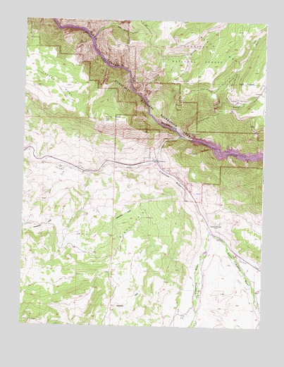
Cimarron, CO USGS Topographic Map
Click on map above to begin viewing in our Map Viewer.

This topographic map contains these locations and features:
Feature Name Type Latitude Longitude GNIS ID View Map
Bear Trap GulchValleyN38.4983°W107.5783°188172View Map
CimarronPopulated PlaceN38.4425°W107.5567°188168View Map
Cimarron CampgroundLocaleN38.4453°W107.5545°196623View Map
Cimarron DitchCanalN38.4203°W107.5726°203334View Map
Cimarron PointCliffN38.4611°W107.5339°188171View Map
Cimarron Post OfficePost OfficeN38.4433°W107.5574°1795044View Map
Cimarron RiverStreamN38.4530°W107.5439°188160View Map
Collier DitchCanalN38.3922°W107.5098°203336View Map
Corral GulchValleyN38.4675°W107.5234°186901View Map
Cottonwood CreekStreamN38.4372°W107.5912°188165View Map
Crystal CreekStreamN38.4922°W107.5898°186888View Map
Crystal ReservoirReservoirN38.4812°W107.5814°169377View Map
Curecanti HeliportAirportN38.4164°W107.5345°204307View Map
Diehl PointRidgeN38.4167°W107.5673°188164View Map
District Number 9 SchoolLocaleN38.4167°W107.5270°188162View Map
Goat Hill MineMineN38.4467°W107.5328°1745579View Map
Little Cimarron RiverStreamN38.4144°W107.5276°188161View Map
Long GulchValleyN38.4703°W107.5658°186887View Map
Marrow Point DamDamN38.4550°W107.5376°196622View Map
Mesa CreekStreamN38.4550°W107.5453°186902View Map
Mesa Creek CampgroundLocaleN38.4755°W107.5217°196625View Map
Morrow PointCliffN38.4678°W107.5451°188170View Map
Morrow Point DamDamN38.4518°W107.5378°200706View Map
Morrow Point ReservoirReservoirN38.4517°W107.5373°200707View Map
Mud SpringsSpringN38.4194°W107.5612°188163View Map
Poverty MesaSummitN38.4728°W107.6189°203335View Map
Sheep KnobSummitN38.4592°W107.5828°188169View Map
Squaw CreekStreamN38.4436°W107.5567°188167View Map
Stumpy CreekStreamN38.4055°W107.5162°188166View Map

Note: Coordinates in the location and feature list above are referenced to NAD83 datum.


Copyright (C) 2008-2025 Ryan Niemi / Sunset Dynamics ... All Rights Reserved