TopoQuest Logo
Do you find TopoQuest useful?
Help keep TopoQuest running and adding new maps/features by donating!
Bitcoin:  19c7KJd3qBynnjoSw5npx9KScwjBe4ifkT
Litecoin:  LXs6TkuXGGXo1vDsWCkWVdjQX94eUKd6ui
Home View Maps Find Maps Find Places Resources & Links


Clarence, Alabama Topographic Map

USGS Map Title: Clarence, AL
USGS Map MRC: 34086A4
DRG (GeoTIFF) Download: o34086a4.tif


Neighboring USGS Topographic Map Quads:


  Holly Pond, AL  
34086B5
 

  Brooksville, AL  
34086B4
 

  Douglas, AL  
34086B3
 

  Blountsville, AL  
34086A5
 

  Clarence, AL  
34086A4
 

  Altoona, AL  
34086A3
 

  Cleveland, AL  
33086H5
 

  Oneonta, AL  
33086H4
 

  Hyatt Gap, AL  
33086H3


Map MRC Location:

N35°
W87°
N35°
W86°
H8 H7 H6 H5 H4 H3 H2 H1
G8 G7 G6 G5 G4 G3 G2 G1
F8 F7 F6 F5 F4 F3 F2 F1
E8 E7 E6 E5 E4 E3 E2 E1
D8 D7 D6 D5 D4 D3 D2 D1
C8 C7 C6 C5 C4 C3 C2 C1
B8 B7 B6 B5 B4 B3 B2 B1
A8 A7 A6 A5 A4 A3 A2 A1
N34°
W87°
N34°
W86°

Clarence, AL USGS 1:24K Topographic Map Preview:
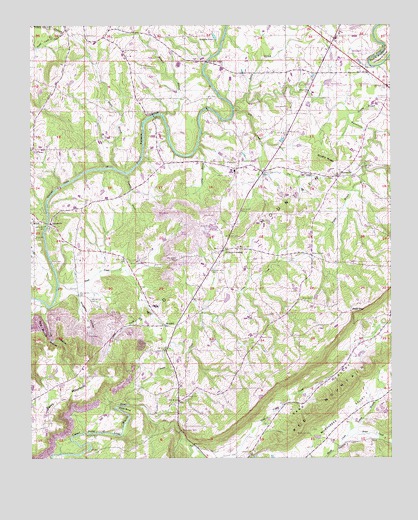
Clarence, AL USGS Topographic Map
Click on map above to begin viewing in our Map Viewer.

This topographic map contains these locations and features:
Feature Name Type Latitude Longitude GNIS ID View Map
Bethel Baptist ChurchChurchN34.1126°W86.3833°151678View Map
Bird (historical)Populated PlaceN34.0298°W86.3892°163164View Map
Brown CemeteryCemeteryN34.0568°W86.4658°114990View Map
Brushy RidgeRidgeN34.0862°W86.3986°115070View Map
Buzzard BranchStreamN34.0995°W86.4550°115329View Map
Bynum CemeteryCemeteryN34.0159°W86.3841°163849View Map
Camp BranchStreamN34.0895°W86.4428°115439View Map
Center ChurchChurchN34.0182°W86.4464°115835View Map
Clarence DivisionCivilN34.0758°W86.3909°165662View Map
Cold BranchStreamN34.0437°W86.4942°116387View Map
Cold Branch HollowValleyN34.0432°W86.4953°116388View Map
Craig (historical)Populated PlaceN34.1220°W86.4375°163169View Map
Dry CreekStreamN34.1018°W86.4292°117543View Map
Ebenezer Methodist ChurchChurchN34.1009°W86.4117°157942View Map
Faulkner FordCrossingN34.0012°W86.4903°156344View Map
Fridays ChapelChurchN34.0632°W86.4255°163858View Map
Fridays CrossingPopulated PlaceN34.0598°W86.4339°118642View Map
Gibbs ChapelChurchN34.1218°W86.4808°118923View Map
Gibbs Chapel CemeteryCemeteryN34.1218°W86.4814°163860View Map
Hales CreekStreamN34.0065°W86.3905°112854View Map
Hamby BranchStreamN34.0995°W86.3892°119623View Map
Handley BranchStreamN34.0823°W86.4669°119671View Map
HendrixPopulated PlaceN34.0382°W86.4533°119962View Map
Hendrix ChurchChurchN34.0590°W86.4725°163863View Map
Hendrix MineMineN34.0279°W86.4653°135104View Map
Honey BranchStreamN34.0832°W86.4700°120320View Map
Hood CemeteryCemeteryN34.0565°W86.4897°120334View Map
Hood CreekStreamN34.0498°W86.4905°120335View Map
Horton Mill BridgeBridgeN34.0076°W86.4489°135108View Map
Hortons MillPopulated PlaceN34.0093°W86.4472°135109View Map
Huldah (historical)LocaleN34.0751°W86.4686°135111View Map
Jones CreekStreamN34.0154°W86.4664°121010View Map
Kenneth Wright DamDamN34.0301°W86.4417°131899View Map
Kings BendBendN34.0145°W86.4678°121233View Map
Lamb CemeteryCemeteryN34.0862°W86.4158°121354View Map
Lebanon CemeteryCemeteryN34.0009°W86.4244°1730270View Map
Lebanon United Methodist ChurchChurchN34.0009°W86.4239°152011View Map
Liberty Hill Baptist ChurchChurchN34.0690°W86.4994°135120View Map
Maple Hill Golf CourseLocaleN34.1015°W86.4014°1700627View Map
Mount Moriah CemeteryCemeteryN34.0065°W86.4033°123247View Map
Mount Moriah CemeteryCemeteryN34.0637°W86.4283°123248View Map
Mount Moriah ChurchChurchN34.0601°W86.4286°123260View Map
Mount ViewLocaleN34.1159°W86.4667°135128View Map
Mount View SchoolSchoolN34.1173°W86.4675°123416View Map
Mount Zion Church of GodChurchN34.0943°W86.4108°152534View Map
Murphy FordCrossingN34.0073°W86.4814°156761View Map
New Home ChurchChurchN34.0459°W86.4061°123773View Map
Painter CemeteryCemeteryN34.0348°W86.4211°124380View Map
Parker BranchStreamN34.0843°W86.3830°124439View Map
Pleasant Hope ChurchChurchN34.0540°W86.4380°125022View Map
Reid GapGapN34.0423°W86.3889°125557View Map
RiversidePopulated PlaceN34.0676°W86.4933°125668View Map
Rocky BranchStreamN34.1051°W86.4250°125806View Map
Royal ChurchChurchN34.0637°W86.4980°153224View Map
Sand Valley CreekStreamN34.0034°W86.4447°153321View Map
Scott Road MineMineN34.1084°W86.3764°135160View Map
Singleton HollowValleyN34.0473°W86.4836°126898View Map
SneadPopulated PlaceN34.1195°W86.3955°127070View Map
Snead Police DepartmentBuildingN34.1194°W86.3940°2751760View Map
Snead Post OfficePost OfficeN34.1166°W86.3923°167232View Map
Snead Volunteer Fire DepartmentBuildingN34.1149°W86.3885°2682834View Map
Spradlin PondReservoirN34.1217°W86.4358°127205View Map
Sprayberry BendBendN34.1157°W86.3780°127208View Map
Stracener BridgeBridgeN34.1145°W86.4394°127447View Map
Susan MoorePopulated PlaceN34.0837°W86.4283°116169View Map
Susan Moore Police DepartmentBuildingN34.0819°W86.4204°2751807View Map
Susan Moore SchoolSchoolN34.0829°W86.4292°135180View Map
Susan Moore Volunteer Fire DepartmentBuildingN34.0819°W86.4202°2683046View Map
Tappan (historical)LocaleN34.1182°W86.4867°135184View Map
Town of SneadCivilN34.1163°W86.3896°2407358View Map
Town of Susan MooreCivilN34.0804°W86.4025°2406699View Map
Wards BridgeBridgeN34.0990°W86.4575°153888View Map
Whippoorwill CreekStreamN34.1009°W86.4300°128845View Map
Wilson ChapelChurchN34.0587°W86.4030°129077View Map
Wrights LakeReservoirN34.0301°W86.4417°131898View Map
WynnvillePopulated PlaceN34.0809°W86.3936°129263View Map
Wynnville Community ChurchChurchN34.0820°W86.3933°163875View Map
Wynnville CreekStreamN34.0757°W86.3792°135190View Map
Yellow BranchStreamN34.0062°W86.3905°129284View Map

Note: Coordinates in the location and feature list above are referenced to NAD83 datum.


Copyright (C) 2008-2024 Ryan Niemi / Sunset Dynamics ... All Rights Reserved