TopoQuest Logo
Do you find TopoQuest useful?
Help keep TopoQuest running and adding new maps/features by donating!
Bitcoin:  19c7KJd3qBynnjoSw5npx9KScwjBe4ifkT
Litecoin:  LXs6TkuXGGXo1vDsWCkWVdjQX94eUKd6ui
Home View Maps Find Maps Find Places Resources & Links


Clarksville, Missouri Topographic Map

USGS Map Title: Clarksville, MO
USGS Map MRC: 39090C8
DRG (GeoTIFF) Download: o39090c8.tif


Neighboring USGS Topographic Map Quads:


  Louisiana, MO  
39091D1
 

  Pleasant Hill West, IL  
39090D8
 

  Pleasant Hill East, IL  
39090D7
 

  Cyrene, MO  
39091C1
 

  Clarksville, MO  
39090C8
 

  Annada, MO  
39090C7
 

  Eolia, MO  
39091B1
 

  Auburn, MO  
39090B8
 

  Elsberry, MO  
39090B7


Map MRC Location:

N40°
W91°
N40°
W90°
H8 H7 H6 H5 H4 H3 H2 H1
G8 G7 G6 G5 G4 G3 G2 G1
F8 F7 F6 F5 F4 F3 F2 F1
E8 E7 E6 E5 E4 E3 E2 E1
D8 D7 D6 D5 D4 D3 D2 D1
C8 C7 C6 C5 C4 C3 C2 C1
B8 B7 B6 B5 B4 B3 B2 B1
A8 A7 A6 A5 A4 A3 A2 A1
N39°
W91°
N39°
W90°

Clarksville, MO USGS 1:24K Topographic Map Preview:
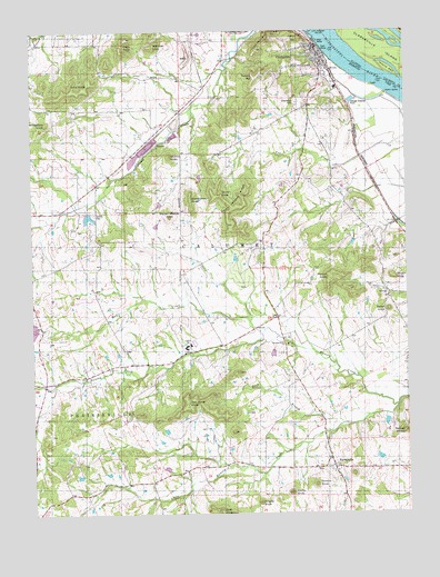
Clarksville, MO USGS Topographic Map
Click on map above to begin viewing in our Map Viewer.

This topographic map contains these locations and features:
Feature Name Type Latitude Longitude GNIS ID View Map
AberdeenLocaleN39.2770°W90.9985°740335View Map
Aberdeen Post Office (historical)Post OfficeN39.2770°W90.9985°759548View Map
Akers School (historical)SchoolN39.2903°W90.9762°741749View Map
Ben Watts KnobSummitN39.2787°W90.9485°713944View Map
Bethlehem KnobSummitN39.3514°W90.9949°714109View Map
Bryant KnobSummitN39.3112°W90.8796°714932View Map
Buck BranchStreamN39.2731°W90.8949°714946View Map
City of ClarksvilleCivilN39.3693°W90.9049°2393545View Map
ClarksvillePopulated PlaceN39.3706°W90.9051°729459View Map
Clarksville IslandIslandN39.3695°W90.8826°406178View Map
Clarksville Post OfficePost OfficeN39.3692°W90.9027°2783047View Map
Clarksville Volunteer Fire DepartmentBuildingN39.3626°W90.9007°2621497View Map
Cooper KnobsRangeN39.2708°W90.8761°716285View Map
Corinth CemeteryCemeteryN39.3278°W90.9790°716312View Map
Corinth ChurchChurchN39.3345°W90.9782°741750View Map
Corinth School (historical)SchoolN39.3352°W90.9780°744247View Map
Dale KnobSummitN39.2509°W90.9382°716644View Map
Farris School (historical)SchoolN39.2892°W90.9465°741748View Map
Forgey KnobSummitN39.2528°W90.9249°718101View Map
Greenwood CemeteryCemeteryN39.3564°W90.9104°718838View Map
Harris KnobSummitN39.2553°W90.9146°719149View Map
Island 464IslandN39.3642°W90.8801°410953View Map
Joseph Keeven DamDamN39.2750°W90.8818°762002View Map
Little Ramsey CreekStreamN39.2778°W90.8785°729537View Map
Lockard Lake DamDamN39.2984°W90.9985°764841View Map
Long KnobSummitN39.3584°W90.9924°721547View Map
Love LakeReservoirN39.3303°W90.9574°761798View Map
Love Lake DamDamN39.3300°W90.9568°761797View Map
Malvern B. Clopton Elementary SchoolSchoolN39.2928°W90.9487°716009View Map
Malvern B. Clopton Junior Senior High SchoolSchoolN39.2933°W90.9483°2651168View Map
Marion Mackey KnobSummitN39.3270°W90.9540°721868View Map
Mcllroy KnobSummitN39.3428°W90.9537°722177View Map
Mud CreekStreamN39.2975°W90.9224°723015View Map
Owens KnobSummitN39.2575°W90.9062°723911View Map
Page KnobSummitN39.3703°W90.9699°723960View Map
Painter KnobSummitN39.3114°W90.9004°723970View Map
Parse Mackey RidgeRidgeN39.3298°W90.9299°724052View Map
PaynesvillePopulated PlaceN39.2625°W90.9004°729602View Map
Pipefitters DamDamN39.3284°W90.9818°761232View Map
Pipefitters LakeReservoirN39.3268°W90.9812°761233View Map
Ramsey Creek ChurchChurchN39.2937°W90.9151°729620View Map
Ramsey School (historical)SchoolN39.2931°W90.9162°741747View Map
Richardson KnobSummitN39.3317°W90.9468°725264View Map
Ripple Lake DamDamN39.3384°W90.9451°762786View Map
Robert HillSummitN39.3628°W90.9243°725392View Map
Salem KnobSummitN39.3025°W90.8810°725943View Map
Salem School (historical)SchoolN39.3059°W90.8805°741746View Map
The PinnacleRidgeN39.3717°W90.9215°727567View Map
Thiel Lake EastReservoirN39.3193°W90.8916°760601View Map
Thiel Lake East DamDamN39.3200°W90.8918°760600View Map
Thiel Lake WestReservoirN39.3216°W90.8982°761944View Map
Thiel Lake West DamDamN39.3217°W90.8968°761943View Map
Tower KnobSummitN39.3331°W90.9365°727724View Map
Township of CalumetCivilN39.3003°W90.8891°767188View Map
Turpin (historical)LocaleN39.2956°W90.9168°745275View Map
Village of PaynesvilleCivilN39.2625°W90.9003°2399638View Map
Weakley LakeReservoirN39.3161°W90.9323°761225View Map
Wilcoxen KnobSummitN39.3712°W90.9593°728826View Map
William B Weakley DamDamN39.3150°W90.9335°761224View Map

Note: Coordinates in the location and feature list above are referenced to NAD83 datum.


Copyright (C) 2008-2024 Ryan Niemi / Sunset Dynamics ... All Rights Reserved