TopoQuest Logo
Do you find TopoQuest useful?
Help keep TopoQuest running and adding new maps/features by donating!
Bitcoin:  19c7KJd3qBynnjoSw5npx9KScwjBe4ifkT
Litecoin:  LXs6TkuXGGXo1vDsWCkWVdjQX94eUKd6ui
Home View Maps Find Maps Find Places Resources & Links


Pleasant Hill East, Illinois Topographic Map

USGS Map Title: Pleasant Hill East, IL
USGS Map MRC: 39090D7
DRG (GeoTIFF) Download: o39090d7.tif


Neighboring USGS Topographic Map Quads:


  Summer Hill, IL  
39090E8
 

  Pittsfield, IL  
39090E7
 

  Milton, IL  
39090E6
 

  Pleasant Hill West, IL  
39090D8
 

  Pleasant Hill East, IL  
39090D7
 

  Pearl West, IL  
39090D6
 

  Clarksville, MO  
39090C8
 

  Annada, MO  
39090C7
 

  Pleasant Dale Valley, IL  
39090C6


Map MRC Location:

N40°
W91°
N40°
W90°
H8 H7 H6 H5 H4 H3 H2 H1
G8 G7 G6 G5 G4 G3 G2 G1
F8 F7 F6 F5 F4 F3 F2 F1
E8 E7 E6 E5 E4 E3 E2 E1
D8 D7 D6 D5 D4 D3 D2 D1
C8 C7 C6 C5 C4 C3 C2 C1
B8 B7 B6 B5 B4 B3 B2 B1
A8 A7 A6 A5 A4 A3 A2 A1
N39°
W91°
N39°
W90°

Pleasant Hill East, IL USGS 1:24K Topographic Map Preview:
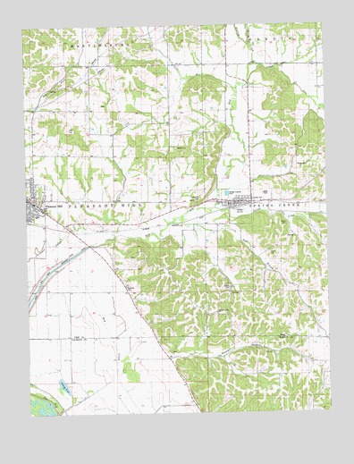
Pleasant Hill East, IL USGS Topographic Map
Click on map above to begin viewing in our Map Viewer.

This topographic map contains these locations and features:
Feature Name Type Latitude Longitude GNIS ID View Map
Allison CemeteryCemeteryN39.4153°W90.7912°403442View Map
Bay Creek Diversion DitchCanalN39.4120°W90.8737°403982View Map
Bayville School (historical)SchoolN39.4217°W90.8385°1725359View Map
Buck BranchStreamN39.4367°W90.8146°405086View Map
Buckeye CreekStreamN39.4937°W90.7815°405115View Map
Carrollton Ridge ChurchChurchN39.4073°W90.7973°405643View Map
Cold RunStreamN39.4784°W90.7868°406340View Map
Cold Run School (historical)SchoolN39.4831°W90.8082°1725371View Map
Crooked SloughGutN39.4262°W90.8726°403299View Map
Dolman PondLakeN39.3843°W90.8608°407294View Map
Elm Grove School (historical)SchoolN39.3800°W90.8076°1748290View Map
Farmers Ridge School (historical)SchoolN39.3842°W90.7535°1748291View Map
Franklin School (historical)SchoolN39.4873°W90.7626°1725382View Map
Fruit Ridge School (historical)SchoolN39.4942°W90.8440°1725384View Map
Hack CemeteryCemeteryN39.4262°W90.7737°409587View Map
Hackberry School (historical)SchoolN39.4723°W90.7826°1725389View Map
Hartsock CemeteryCemeteryN39.4742°W90.8429°1852480View Map
Haulford School (historical)SchoolN39.4131°W90.7537°1725390View Map
Henry CemeteryCemeteryN39.4142°W90.8315°1852481View Map
Hollis CemeteryCemeteryN39.4356°W90.7671°410399View Map
Honey CreekStreamN39.4873°W90.7801°410475View Map
Howell HollowValleyN39.3930°W90.8160°410625View Map
Hunter CemeteryCemeteryN39.4434°W90.7796°410695View Map
Hutton CemeteryCemeteryN39.4437°W90.8029°410738View Map
Jacksonville School (historical)SchoolN39.4434°W90.8240°1725400View Map
Lakeview School (historical)SchoolN39.3762°W90.8601°1748302View Map
Mason CemeteryCemeteryN39.4609°W90.8126°413097View Map
NeboPopulated PlaceN39.4425°W90.7910°414330View Map
Nebo Baptist ChurchChurchN39.4437°W90.7885°1962298View Map
Nebo Post OfficePost OfficeN39.4427°W90.7909°2788203View Map
Neese CemeteryCemeteryN39.4548°W90.7623°414336View Map
Oakland School (historical)SchoolN39.4675°W90.8340°1725420View Map
Old Baptist School (historical)SchoolN39.4437°W90.7643°1725422View Map
Pleasant HillPopulated PlaceN39.4434°W90.8724°415817View Map
Pleasant Hill Baptist ChurchChurchN39.4445°W90.8715°1962299View Map
Pleasant Hill Christian ChurchChurchN39.4434°W90.8726°1962300View Map
Pleasant Hill Elementary SchoolSchoolN39.4406°W90.8682°1822223View Map
Pleasant Hill High SchoolSchoolN39.4392°W90.8707°1822224View Map
Pleasant Hill Post OfficePost OfficeN39.4433°W90.8714°2788255View Map
Round Pond (historical)LakeN39.3898°W90.8468°1748322View Map
Sideview School (historical)SchoolN39.4212°W90.7957°1725448View Map
Spring CreekStreamN39.4412°W90.7971°418938View Map
Spring Creek Fire Protection DistrictBuildingN39.4446°W90.7873°2640319View Map
Township of Pleasant HillCivilN39.4439°W90.8590°429578View Map
Twin Ponds (historical)LakeN39.3764°W90.8412°1748332View Map
Venable CemeteryCemeteryN39.4253°W90.8323°1852499View Map
Village of NeboCivilN39.4421°W90.7881°2399440View Map
Village of Pleasant HillCivilN39.4434°W90.8728°2399692View Map

Note: Coordinates in the location and feature list above are referenced to NAD83 datum.


Copyright (C) 2008-2024 Ryan Niemi / Sunset Dynamics ... All Rights Reserved