TopoQuest Logo
Do you find TopoQuest useful?
Help keep TopoQuest running and adding new maps/features by donating!
Bitcoin:  19c7KJd3qBynnjoSw5npx9KScwjBe4ifkT
Litecoin:  LXs6TkuXGGXo1vDsWCkWVdjQX94eUKd6ui
Home View Maps Find Maps Find Places Resources & Links


Claverack, New York Topographic Map

USGS Map Title: Claverack, NY
USGS Map MRC: 42073B6
DRG (GeoTIFF) Download: o42073b6.tif


Neighboring USGS Topographic Map Quads:


  Hudson North, NY  
42073C7
 

  Stottville, NY  
42073C6
 

  Chatham, NY  
42073C5
 

  Hudson South, NY  
42073B7
 

  Claverack, NY  
42073B6
 

  Hillsdale, NY  
42073B5
 

  Clermont, NY  
42073A7
 

  Ancram, NY  
42073A6
 

  Copake, NY  
42073A5


Map MRC Location:

N43°
W74°
N43°
W73°
H8 H7 H6 H5 H4 H3 H2 H1
G8 G7 G6 G5 G4 G3 G2 G1
F8 F7 F6 F5 F4 F3 F2 F1
E8 E7 E6 E5 E4 E3 E2 E1
D8 D7 D6 D5 D4 D3 D2 D1
C8 C7 C6 C5 C4 C3 C2 C1
B8 B7 B6 B5 B4 B3 B2 B1
A8 A7 A6 A5 A4 A3 A2 A1
N42°
W74°
N42°
W73°

Claverack, NY USGS 1:24K Topographic Map Preview:
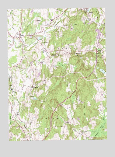
Claverack, NY USGS Topographic Map
Click on map above to begin viewing in our Map Viewer.

This topographic map contains these locations and features:
Feature Name Type Latitude Longitude GNIS ID View Map
Blackberry Hill FarmLocaleN42.1739°W73.7433°2555702View Map
Buttermilk FallsFallsN42.2181°W73.7040°945364View Map
ChurchtownPopulated PlaceN42.1762°W73.7187°946687View Map
Churchtown Fire Company 1BuildingN42.1774°W73.7189°2734751View Map
Churchtown ReservoirReservoirN42.1650°W73.7158°946688View Map
ClaverackPopulated PlaceN42.2251°W73.7346°946802View Map
Claverack Fire District A B Shaw Fire CompanyBuildingN42.2241°W73.7296°2718433View Map
Claverack Free LibraryBuildingN42.2228°W73.7355°2617247View Map
Claverack-Red Mills Census Designated PlaceCensusN42.2263°W73.7269°2389326View Map
Columbia Country ClubLocaleN42.2348°W73.6960°974356View Map
Country Club School (historical)SchoolN42.2356°W73.6947°2106782View Map
East TaghkanicPopulated PlaceN42.1320°W73.6573°949255View Map
Forest PondLakeN42.1897°W73.6289°950423View Map
Glenco MillsPopulated PlaceN42.1495°W73.7407°951198View Map
Hess PondLakeN42.2327°W73.6777°2106781View Map
High FallsFallsN42.2462°W73.6493°952728View Map
HollowvillePopulated PlaceN42.2054°W73.6912°953007View Map
Hollowville CreekStreamN42.2226°W73.7032°953008View Map
Hollowville Trailer ParkPopulated PlaceN42.2047°W73.6964°2496637View Map
Jutkosky CourtPopulated PlaceN42.2147°W73.7478°2426833View Map
Lilli PondLakeN42.2098°W73.7027°955299View Map
Linlithgo MillsPopulated PlaceN42.1743°W73.7468°972727View Map
Manor RockPillarN42.1637°W73.6635°956377View Map
MartindalePopulated PlaceN42.2070°W73.6318°956597View Map
Moore PondLakeN42.2355°W73.6516°957602View Map
Neiber SwampSwampN42.1448°W73.7476°958351View Map
Ockawamick Central SchoolSchoolN42.2381°W73.6943°959218View Map
PhilmontPopulated PlaceN42.2484°W73.6532°960311View Map
Philmont Post OfficePost OfficeN42.2498°W73.6488°2618061View Map
Philmont Rescue SquadBuildingN42.2493°W73.6488°2720192View Map
Philmont Volunteer Fire Company 1BuildingN42.2495°W73.6485°2734720View Map
Pine HillSummitN42.1276°W73.7493°970477View Map
PinnaclePillarN42.1573°W73.6846°960598View Map
Pumpkin Hollow SwampSwampN42.1376°W73.6310°961973View Map
Pumpkin Ridge FarmLocaleN42.1267°W73.6272°2518631View Map
Red MillsPopulated PlaceN42.2209°W73.7118°962310View Map
Reformed Dutch ChurchChurchN42.2281°W73.7333°2616824View Map
Sacred Heart ChurchChurchN42.2497°W73.6464°2496337View Map
Saint Marks Episcopal ChurchChurchN42.2492°W73.6494°2496357View Map
Saint Thomas Lutheran ChurchChurchN42.1755°W73.7188°2617044View Map
School Number 12 (historical)SchoolN42.1775°W73.7308°2106783View Map
School Number 5 (historical)SchoolN42.1636°W73.7119°2106784View Map
School Number 7 (historical)SchoolN42.1440°W73.7418°975517View Map
Second Reformed ChurchChurchN42.2494°W73.6511°2496338View Map
Shad SwampSwampN42.1968°W73.6823°964903View Map
Stever PondLakeN42.2384°W73.6463°966394View Map
Sugarloaf HillSummitN42.2387°W73.7123°966724View Map
Taconic OrchardsLocaleN42.1422°W73.7383°2516879View Map
TaghkanicPopulated PlaceN42.1423°W73.6773°966995View Map
Taghkanic Center ChurchChurchN42.1340°W73.6662°966996View Map
Taghkanic Volunteer Fire Company 1 East Taghkanic Station 2BuildingN42.1310°W73.6612°2734725View Map
Texas SwampSwampN42.1470°W73.6529°967186View Map
The Farm At Miller's CrossingLocaleN42.2336°W73.6906°2555714View Map
The HillSummitN42.1776°W73.7487°967263View Map
Town of ClaverackCivilN42.2235°W73.6873°978834View Map
Town of TaghkanicCivilN42.1333°W73.6734°979540View Map
Trinity ChurchChurchN42.2229°W73.7376°967819View Map
Upper HollowvillePopulated PlaceN42.2068°W73.6643°968276View Map
Village of PhilmontCivilN42.2477°W73.6463°2391062View Map
Weigelt PondLakeN42.2344°W73.6649°969017View Map

Note: Coordinates in the location and feature list above are referenced to NAD83 datum.


Copyright (C) 2008-2024 Ryan Niemi / Sunset Dynamics ... All Rights Reserved