TopoQuest Logo
Do you find TopoQuest useful?
Help keep TopoQuest running and adding new maps/features by donating!
Bitcoin:  19c7KJd3qBynnjoSw5npx9KScwjBe4ifkT
Litecoin:  LXs6TkuXGGXo1vDsWCkWVdjQX94eUKd6ui
Home View Maps Find Maps Find Places Resources & Links


Clayton, Washington Topographic Map

USGS Map Title: Clayton, WA
USGS Map MRC: 47117H5
DRG (GeoTIFF) Download: o47117h5.tif


Neighboring USGS Topographic Map Quads:


  Springdale, WA  
48117A6
 

  Deer Lake, WA  
48117A5
 

  Fan Lake, WA  
48117A4
 

  Tumtum, WA  
47117H6
 

  Clayton, WA  
47117H5
 

  Deer Park, WA  
47117H4
 

  Four Mound Prairie, WA  
47117G6
 

  Nine Mile Falls, WA  
47117G5
 

  Dartford, WA  
47117G4


Map MRC Location:

N48°
W118°
N48°
W117°
H8 H7 H6 H5 H4 H3 H2 H1
G8 G7 G6 G5 G4 G3 G2 G1
F8 F7 F6 F5 F4 F3 F2 F1
E8 E7 E6 E5 E4 E3 E2 E1
D8 D7 D6 D5 D4 D3 D2 D1
C8 C7 C6 C5 C4 C3 C2 C1
B8 B7 B6 B5 B4 B3 B2 B1
A8 A7 A6 A5 A4 A3 A2 A1
N47°
W118°
N47°
W117°

Clayton, WA USGS 1:24K Topographic Map Preview:
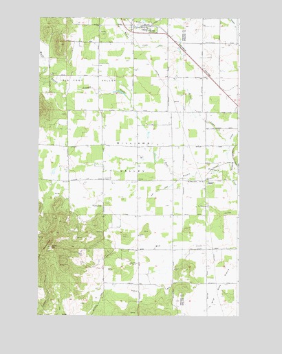
Clayton, WA USGS Topographic Map
Click on map above to begin viewing in our Map Viewer.

This topographic map contains these locations and features:
Feature Name Type Latitude Longitude GNIS ID View Map
Beaver CreekStreamN47.9457°W117.5061°1516319View Map
Big Foot ValleyValleyN47.9574°W117.5608°1503345View Map
Burroughs SchoolSchoolN47.9324°W117.5199°1503669View Map
ChristiansonsLocaleN47.9924°W117.5450°1511750View Map
ClaytonPopulated PlaceN47.9968°W117.5583°1504000View Map
Clayton Community Bible ChurchChurchN47.9949°W117.5600°2609383View Map
Clayton Meadows Mobile Home ParkPopulated PlaceN47.9945°W117.5626°2607163View Map
Clayton Post OfficePost OfficeN47.9967°W117.5594°2781696View Map
Cross Winds AirportAirportN47.9789°W117.5261°1533710View Map
Deer Flat AirportAirportN47.9569°W117.5991°2443367View Map
Dunns MountainSummitN47.9038°W117.6169°1504593View Map
Fielding Airport (historical)AirportN47.8843°W117.5136°1533739View Map
Frog CreekStreamN47.9332°W117.5372°1505053View Map
HazardPopulated PlaceN47.8777°W117.5188°1514873View Map
Keystone CornersLocaleN47.9318°W117.5208°1505964View Map
Lenhard ReservoirReservoirN47.9499°W117.5577°1532531View Map
Lenhard Reservoir DamDamN47.9499°W117.5577°1532530View Map
North Vista Mobile Home ParkPopulated PlaceN47.9807°W117.5250°2607164View Map
Spring CreekStreamN47.9516°W117.5011°1508623View Map
Stevens County Fire District 1 Station 1 ClaytonBuildingN47.9945°W117.5529°2619753View Map
Stevens County Fire District 1 Station 3 - Twin MountainBuildingN47.8994°W117.5630°2619739View Map
Twin Mountain Fire StationLocaleN47.8968°W117.5624°1509153View Map
Twin MountainsRangeN47.9016°W117.6225°1509154View Map
Wild Rose PrairieFlatN47.8899°W117.5099°1509511View Map
Williams ValleyValleyN47.9349°W117.5269°1509538View Map
Williams Valley Hillside CemeteryCemeteryN47.9210°W117.5851°1509539View Map

Note: Coordinates in the location and feature list above are referenced to NAD83 datum.


Copyright (C) 2008-2024 Ryan Niemi / Sunset Dynamics ... All Rights Reserved