TopoQuest Logo
Do you find TopoQuest useful?
Help keep TopoQuest running and adding new maps/features by donating!
Bitcoin:  19c7KJd3qBynnjoSw5npx9KScwjBe4ifkT
Litecoin:  LXs6TkuXGGXo1vDsWCkWVdjQX94eUKd6ui
Home View Maps Find Maps Find Places Resources & Links


Deer Park, Washington Topographic Map

USGS Map Title: Deer Park, WA
USGS Map MRC: 47117H4
DRG (GeoTIFF) Download: o47117h4.tif


Neighboring USGS Topographic Map Quads:


  Deer Lake, WA  
48117A5
 

  Fan Lake, WA  
48117A4
 

  Elk, WA  
48117A3
 

  Clayton, WA  
47117H5
 

  Deer Park, WA  
47117H4
 

  Chattaroy, WA  
47117H3
 

  Nine Mile Falls, WA  
47117G5
 

  Dartford, WA  
47117G4
 

  Mead, WA  
47117G3


Map MRC Location:

N48°
W118°
N48°
W117°
H8 H7 H6 H5 H4 H3 H2 H1
G8 G7 G6 G5 G4 G3 G2 G1
F8 F7 F6 F5 F4 F3 F2 F1
E8 E7 E6 E5 E4 E3 E2 E1
D8 D7 D6 D5 D4 D3 D2 D1
C8 C7 C6 C5 C4 C3 C2 C1
B8 B7 B6 B5 B4 B3 B2 B1
A8 A7 A6 A5 A4 A3 A2 A1
N47°
W118°
N47°
W117°

Deer Park, WA USGS 1:24K Topographic Map Preview:
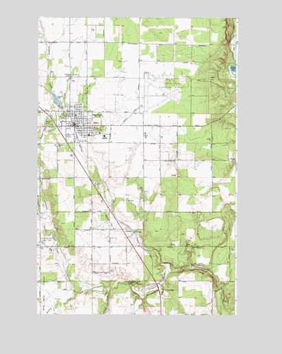
Deer Park, WA USGS Topographic Map
Click on map above to begin viewing in our Map Viewer.

This topographic map contains these locations and features:
Feature Name Type Latitude Longitude GNIS ID View Map
Arcadia Elementary SchoolSchoolN47.9501°W117.4581°1503051View Map
Arcadia ParkParkN47.9527°W117.4611°1514382View Map
Assembly of God Tri - County Christian CenterChurchN47.9465°W117.4668°2608662View Map
Bailey LakeLakeN47.9784°W117.3773°1503120View Map
Christ Church of Deer ParkChurchN47.9543°W117.4978°2609421View Map
City of Deer ParkCivilN47.9642°W117.4398°2410312View Map
Deer ParkPopulated PlaceN47.9543°W117.4769°1512143View Map
Deer Park AirportAirportN47.9658°W117.4337°1533737View Map
Deer Park AmbulanceBuildingN47.9550°W117.4745°2643772View Map
Deer Park Church of NazareneChurchN47.9576°W117.4730°2609422View Map
Deer Park DivisionCivilN47.9124°W117.4368°1939493View Map
Deer Park Elementary SchoolSchoolN47.9501°W117.4536°1514536View Map
Deer Park First Baptist ChurchChurchN47.9549°W117.4582°2609423View Map
Deer Park Health Center and HospitalHospitalN47.9512°W117.4614°1514498View Map
Deer Park High SchoolSchoolN47.9462°W117.4569°1513738View Map
Deer Park Post OfficePost OfficeN47.9537°W117.4751°2781586View Map
Deer Park United Methodist ChurchChurchN47.9566°W117.4747°2609424View Map
DenisonPopulated PlaceN47.9096°W117.4386°1510912View Map
Dragoon Creek State ParkParkN47.8885°W117.4424°1504531View Map
Dragoon LakeReservoirN47.9653°W117.4881°1513918View Map
Dragoon Lake DamDamN47.9632°W117.4877°1532379View Map
Ecks CreekStreamN47.9924°W117.4966°1529955View Map
Faith Lutheran ChurchChurchN47.9521°W117.4553°2608797View Map
Flying Firemen FacilityBuildingN47.9668°W117.4366°2619511View Map
Grace Evangelical Free ChurchChurchN47.9491°W117.4695°2609425View Map
Hite ParkParkN47.9588°W117.4830°1513127View Map
Huston CreekStreamN47.8846°W117.4549°1505679View Map
KAZZ-FM (Deer Park)TowerN47.9524°W117.4777°1534341View Map
Kelly CemeteryCemeteryN47.9597°W117.4684°1505934View Map
Kingdom Hall of Jehovahs WitnessesChurchN47.9517°W117.4830°2609426View Map
Little Trout LakeLakeN47.9830°W117.3752°1506234View Map
Monroe Road BridgeBridgeN47.9157°W117.4983°2729588View Map
Mud CreekStreamN47.9013°W117.4902°1506861View Map
Open Door Congregational ChurchChurchN47.9566°W117.4775°2609427View Map
Perrins FieldParkN47.9546°W117.4730°1514340View Map
Radial Flyer AirportAirportN47.8934°W117.4426°2717114View Map
Saint Mary's ChurchChurchN47.9577°W117.4765°2609428View Map
Spokane County Fire District 4 Station 41 Deer ParkBuildingN47.9535°W117.4715°2643773View Map
Spokane State Game FarmLocaleN47.9052°W117.4972°1533229View Map
T Bridge CornerPopulated PlaceN47.9749°W117.4794°1511358View Map
Tri-County FairgroundsLocaleN47.9477°W117.4755°1513226View Map
Turpentine HollowValleyN47.9185°W117.4997°1509133View Map
West Branch Dragoon CreekStreamN47.9157°W117.4991°1527913View Map
Wethey CreekStreamN47.8874°W117.4688°1509440View Map
Woodland CemeteryCemeteryN47.9551°W117.4920°1509619View Map
Zion Lutheran ChurchChurchN47.9540°W117.4730°2609429View Map

Note: Coordinates in the location and feature list above are referenced to NAD83 datum.


Copyright (C) 2008-2024 Ryan Niemi / Sunset Dynamics ... All Rights Reserved