TopoQuest Logo
Do you find TopoQuest useful?
Help keep TopoQuest running and adding new maps/features by donating!
Bitcoin:  19c7KJd3qBynnjoSw5npx9KScwjBe4ifkT
Litecoin:  LXs6TkuXGGXo1vDsWCkWVdjQX94eUKd6ui
Home View Maps Find Maps Find Places Resources & Links


Clearwater, Kansas Topographic Map

USGS Map Title: Clearwater, KS
USGS Map MRC: 37097E5
DRG (GeoTIFF) Download: o37097e5.tif


Neighboring USGS Topographic Map Quads:


  Garden Plain, KS  
37097F6
 

  Goddard, KS  
37097F5
 

  Wichita West, KS  
37097F4
 

  Lake Afton, KS  
37097E6
 

  Clearwater, KS  
37097E5
 

  Bayneville, KS  
37097E4
 

  Conway Springs, KS  
37097D6
 

  Millerton, KS  
37097D5
 

  Zyba, KS  
37097D4


Map MRC Location:

N38°
W98°
N38°
W97°
H8 H7 H6 H5 H4 H3 H2 H1
G8 G7 G6 G5 G4 G3 G2 G1
F8 F7 F6 F5 F4 F3 F2 F1
E8 E7 E6 E5 E4 E3 E2 E1
D8 D7 D6 D5 D4 D3 D2 D1
C8 C7 C6 C5 C4 C3 C2 C1
B8 B7 B6 B5 B4 B3 B2 B1
A8 A7 A6 A5 A4 A3 A2 A1
N37°
W98°
N37°
W97°

Clearwater, KS USGS 1:24K Topographic Map Preview:
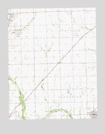
Clearwater, KS USGS Topographic Map
Click on map above to begin viewing in our Map Viewer.

This topographic map contains these locations and features:
Feature Name Type Latitude Longitude GNIS ID View Map
Afton (historical)LocaleN37.6056°W97.5934°482578View Map
Chambers Northeast Oil FieldOilfieldN37.5567°W97.5084°474312View Map
ClearwaterPopulated PlaceN37.5028°W97.5045°474315View Map
Clearwater CemeteryCemeteryN37.5118°W97.5052°2673357View Map
Clearwater City HallBuildingN37.5044°W97.5056°2509893View Map
Clearwater Elementary West SchoolSchoolN37.5037°W97.5017°2497564View Map
Clearwater Fire DepartmentBuildingN37.5043°W97.5093°2111202View Map
Clearwater Golf CourseLocaleN37.5233°W97.5031°2510496View Map
Clearwater Oil FieldOilfieldN37.5611°W97.5120°474311View Map
Clearwater Police DepartmentBuildingN37.5044°W97.5054°2504249View Map
Clearwater Public LibraryBuildingN37.5044°W97.5057°2510372View Map
Clearwater United Methodist ChurchChurchN37.5052°W97.5003°2509896View Map
ClonmelPopulated PlaceN37.5628°W97.5539°484677View Map
Colonial Estates Mobile Home ParkPopulated PlaceN37.5679°W97.5511°2510125View Map
First Baptist ChurchChurchN37.5050°W97.5029°2511039View Map
Lake WaltannaReservoirN37.5981°W97.6128°481013View Map
Lake Waltanna AirportAirportN37.5916°W97.6142°481399View Map
Old Saint Johns CemeteryCemeteryN37.5822°W97.5709°474314View Map
Ruby (historical)LocaleN37.5792°W97.5164°482579View Map
Ruby CemeteryCemeteryN37.5621°W97.5162°474313View Map
Saint Johns CemeteryCemeteryN37.5644°W97.5556°2673361View Map
Spring CreekStreamN37.5095°W97.5634°474310View Map
Thome Turkey FarmLocaleN37.6200°W97.5331°2726908View Map
Township of IllinoisCivilN37.6059°W97.5347°474006View Map
Township of NinnescahCivilN37.5190°W97.5335°470254View Map
Weiss Acres AirportAirportN37.5251°W97.6036°2770405View Map

Note: Coordinates in the location and feature list above are referenced to NAD83 datum.


Copyright (C) 2008-2025 Ryan Niemi / Sunset Dynamics ... All Rights Reserved