TopoQuest Logo
Do you find TopoQuest useful?
Help keep TopoQuest running and adding new maps/features by donating!
Bitcoin:  19c7KJd3qBynnjoSw5npx9KScwjBe4ifkT
Litecoin:  LXs6TkuXGGXo1vDsWCkWVdjQX94eUKd6ui
Home View Maps Find Maps Find Places Resources & Links


Goddard, Kansas Topographic Map

USGS Map Title: Goddard, KS
USGS Map MRC: 37097F5
DRG (GeoTIFF) Download: o37097f5.tif


Neighboring USGS Topographic Map Quads:


  Mount Hope, KS  
37097G6
 

  Colwich, KS  
37097G5
 

  Maize, KS  
37097G4
 

  Garden Plain, KS  
37097F6
 

  Goddard, KS  
37097F5
 

  Wichita West, KS  
37097F4
 

  Lake Afton, KS  
37097E6
 

  Clearwater, KS  
37097E5
 

  Bayneville, KS  
37097E4


Map MRC Location:

N38°
W98°
N38°
W97°
H8 H7 H6 H5 H4 H3 H2 H1
G8 G7 G6 G5 G4 G3 G2 G1
F8 F7 F6 F5 F4 F3 F2 F1
E8 E7 E6 E5 E4 E3 E2 E1
D8 D7 D6 D5 D4 D3 D2 D1
C8 C7 C6 C5 C4 C3 C2 C1
B8 B7 B6 B5 B4 B3 B2 B1
A8 A7 A6 A5 A4 A3 A2 A1
N37°
W98°
N37°
W97°

Goddard, KS USGS 1:24K Topographic Map Preview:
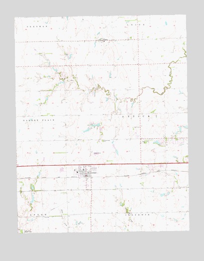
Goddard, KS USGS Topographic Map
Click on map above to begin viewing in our Map Viewer.

This topographic map contains these locations and features:
Feature Name Type Latitude Longitude GNIS ID View Map
Afton CemeteryCemeteryN37.6340°W97.6063°474004View Map
All Seasons Campground and Recreational Vehicle ParkLocaleN37.6805°W97.5190°2510679View Map
Amelia Earhart Elementary SchoolSchoolN37.6486°W97.5631°2497475View Map
Apollo Elementary SchoolSchoolN37.6697°W97.5273°2720292View Map
Auburn Hills Golf CourseLocaleN37.6744°W97.5006°2509729View Map
Challenger Intermediate SchoolSchoolN37.6594°W97.5813°2497385View Map
Chikaskia CemeteryCemeteryN37.6457°W97.5825°470313View Map
City of GoddardCivilN37.6658°W97.5622°2394919View Map
Clark Davidson Elementary SchoolSchoolN37.6534°W97.5813°2497550View Map
Diamond Spur Trailer CourtPopulated PlaceN37.6632°W97.5194°2510642View Map
Discovery Intermediate SchoolSchoolN37.6545°W97.5769°2497474View Map
Eck FieldAirportN37.6936°W97.5436°481400View Map
Eisenhower High SchoolSchoolN37.6706°W97.5326°2703465View Map
Eisenhower Middle SchoolSchoolN37.6726°W97.5277°2497396View Map
Explorer Elementary SchoolSchoolN37.6749°W97.5329°2497394View Map
First Baptist ChurchChurchN37.6595°W97.5760°2509875View Map
Germania (historical)LocaleN37.7361°W97.5928°482575View Map
GoddardPopulated PlaceN37.6597°W97.5753°474001View Map
Goddard AcademySchoolN37.6490°W97.5676°2497554View Map
Goddard City OfficesBuildingN37.6579°W97.5748°2510426View Map
Goddard Community CenterBuildingN37.6580°W97.5747°2510459View Map
Goddard High SchoolSchoolN37.6470°W97.5687°480996View Map
Goddard Industrial ParkLocaleN37.6542°W97.5686°2509534View Map
Goddard Intermediate SchoolSchoolN37.6611°W97.5770°480999View Map
Goddard Middle SchoolSchoolN37.6443°W97.5698°480997View Map
Goddard Municipal CourtBuildingN37.6579°W97.5748°2510427View Map
Goddard Police DepartmentBuildingN37.6578°W97.5745°2503777View Map
Goddard Post OfficePost OfficeN37.6600°W97.5746°2511096View Map
Goddard Primary Learning CenterSchoolN37.6611°W97.5768°480998View Map
Goddard Public LibraryBuildingN37.6579°W97.5748°2510428View Map
Goddard United Methodist ChurchChurchN37.6596°W97.5735°2510917View Map
Goddard United School District 265 Police DepartmentBuildingN37.6545°W97.5768°2504265View Map
Goddard Wastewater PlantLocaleN37.6711°W97.5669°2511219View Map
Heartland Church of ChristChurchN37.6776°W97.5301°2511082View Map
Holy Spirit Catholic SchoolSchoolN37.6661°W97.5518°2497634View Map
Linnell Mobile Home ParkPopulated PlaceN37.6631°W97.5705°2510089View Map
Maple Village Mobile Home ParkPopulated PlaceN37.6797°W97.5379°2510742View Map
Medicalodge of Goddard Nursing HomeBuildingN37.6612°W97.5831°2509762View Map
Miller Farm Airport (historical)AirportN37.6583°W97.5587°481401View Map
Oak Street Elementary SchoolSchoolN37.6614°W97.5766°2497395View Map
Pleasant Ridge CemeteryCemeteryN37.6779°W97.5632°474002View Map
Saint Mark CemeteryCemeteryN37.7384°W97.5633°2673363View Map
Saint Mark's SchoolSchoolN37.7350°W97.5600°2497433View Map
Saint MarksPopulated PlaceN37.7358°W97.5623°474003View Map
Saint Marks Catholic ChurchChurchN37.7364°W97.5637°2510839View Map
Sedgwick County Emergency Medical Service Post 7BuildingN37.6658°W97.5718°2696533View Map
Sedgwick County Fire District 1 Station 35BuildingN37.6657°W97.5718°2111853View Map
Sedgwick County Rural Water District 4 Water TowerTowerN37.6711°W97.5346°2509614View Map
Tanganyika Wildlife ParkLocaleN37.6759°W97.5557°2510307View Map
The Church of the Holy SpiritChurchN37.6661°W97.5520°2510766View Map
Township of AtticaCivilN37.6946°W97.5439°474005View Map
Wichita Friends Childrens SchoolSchoolN37.6647°W97.5108°2497348View Map
Wichita Regency Mobile Home CommunityPopulated PlaceN37.6615°W97.5278°2510700View Map

Note: Coordinates in the location and feature list above are referenced to NAD83 datum.


Copyright (C) 2008-2025 Ryan Niemi / Sunset Dynamics ... All Rights Reserved