TopoQuest Logo
Do you find TopoQuest useful?
Help keep TopoQuest running and adding new maps/features by donating!
Bitcoin:  19c7KJd3qBynnjoSw5npx9KScwjBe4ifkT
Litecoin:  LXs6TkuXGGXo1vDsWCkWVdjQX94eUKd6ui
Home View Maps Find Maps Find Places Resources & Links


Clemmons, North Carolina Topographic Map

USGS Map Title: Clemmons, NC
USGS Map MRC: 36080A4
DRG (GeoTIFF) Download: o36080a4.tif


Neighboring USGS Topographic Map Quads:


  East Bend, NC  
36080B5
 

  Vienna, NC  
36080B4
 

  Rural Hall, NC  
36080B3
 

  Farmington, NC  
36080A5
 

  Clemmons, NC  
36080A4
 

  Winston-Salem West, NC  
36080A3
 

  Mocksville, NC  
35080H5
 

  Advance, NC  
35080H4
 

  Welcome, NC  
35080H3


Map MRC Location:

N37°
W81°
N37°
W80°
H8 H7 H6 H5 H4 H3 H2 H1
G8 G7 G6 G5 G4 G3 G2 G1
F8 F7 F6 F5 F4 F3 F2 F1
E8 E7 E6 E5 E4 E3 E2 E1
D8 D7 D6 D5 D4 D3 D2 D1
C8 C7 C6 C5 C4 C3 C2 C1
B8 B7 B6 B5 B4 B3 B2 B1
A8 A7 A6 A5 A4 A3 A2 A1
N36°
W81°
N36°
W80°

Clemmons, NC USGS 1:24K Topographic Map Preview:
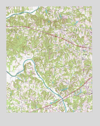
Clemmons, NC USGS Topographic Map
Click on map above to begin viewing in our Map Viewer.

This topographic map contains these locations and features:
Feature Name Type Latitude Longitude GNIS ID View Map
All-American Rose Selections GardenParkN36.0029°W80.4062°1007380View Map
Arnold LakeReservoirN36.0972°W80.4927°1000069View Map
Arnold Lake DamDamN36.0968°W80.4931°1000068View Map
Beauchamp LakeReservoirN36.0988°W80.3760°1000072View Map
Bermuda RunPopulated PlaceN36.0037°W80.4220°1002207View Map
Bermuda Run Golf CourseLocaleN36.0040°W80.4192°1002201View Map
Blacks CreekStreamN36.0657°W80.4598°981560View Map
Blanket CreekStreamN36.0215°W80.4253°1019216View Map
Boyers ChurchChurchN36.0504°W80.3764°981793View Map
CaperniumPopulated PlaceN36.0543°W80.4167°982633View Map
Capernium ChurchChurchN36.0493°W80.4176°982634View Map
Center Grove ChurchChurchN36.0435°W80.4356°982937View Map
Cinnamon RidgePopulated PlaceN36.1126°W80.4317°1005511View Map
ClemmonsPopulated PlaceN36.0215°W80.3820°1019693View Map
Clemmons CenterLocaleN36.0224°W80.3801°1007127View Map
Clemmons Elementary SchoolSchoolN36.0226°W80.3756°1007126View Map
Clemmons Fire Department Station 10BuildingN36.0426°W80.3854°2639760View Map
Clemmons Fire Department Station 14BuildingN36.0229°W80.3781°2638896View Map
Clemmons Post OfficePost OfficeN36.0224°W80.3807°2773860View Map
Clemmons Village Shopping CenterLocaleN36.0210°W80.3803°1007125View Map
Clemmons WestPopulated PlaceN36.0087°W80.3853°1005520View Map
Concord ChurchChurchN36.0743°W80.4384°983437View Map
Conrad LakeReservoirN36.1194°W80.4412°1000121View Map
Conrad Lake DamDamN36.1218°W80.4414°1000120View Map
CreekwoodPopulated PlaceN36.0090°W80.4581°1002202View Map
Cutters CreekPopulated PlaceN36.1190°W80.3801°1005513View Map
Davie County Emergency Medical Services Station 2BuildingN36.0110°W80.4440°2720458View Map
Davie GardensPopulated PlaceN36.0168°W80.4642°1002203View Map
Double CreekStreamN36.0629°W80.4637°984282View Map
Durham LakeReservoirN36.1072°W80.4373°1000091View Map
Durham Lake DamDamN36.1085°W80.4381°1000090View Map
EaglewoodPopulated PlaceN36.1071°W80.4270°1005512View Map
Ellison CreekStreamN36.0432°W80.4517°984741View Map
Forbush SchoolSchoolN36.1237°W80.4956°985264View Map
Forest Hills EstatesPopulated PlaceN36.0304°W80.4170°1005515View Map
Fred Bahnson Number One DamDamN36.0118°W80.4331°999904View Map
Fred Bahnson Number One LakeReservoirN36.0119°W80.4318°999903View Map
Fred Bahnson Number Two DamDamN36.0151°W80.4281°999910View Map
Fred Bahnson Number Two LakeReservoirN36.0145°W80.4269°999909View Map
Grapevine ChurchChurchN36.1187°W80.4356°985938View Map
GrapewoodPopulated PlaceN36.1199°W80.4384°1020500View Map
Halls Ferry siteLocaleN36.0132°W80.4170°1008055View Map
Harmony GrovePopulated PlaceN36.0801°W80.3864°986424View Map
Hauser CreekStreamN36.0468°W80.4484°986502View Map
Haynes Estate Dam Number OneDamN36.0035°W80.3931°999889View Map
Haynes Estate Dam Number TwoDamN36.0085°W80.3881°999897View Map
Haynes Estate Lake Number OneReservoirN36.0030°W80.3926°999890View Map
HillsdalePopulated PlaceN36.0051°W80.4395°986831View Map
Hillsdale Census Designated PlaceCensusN36.0110°W80.4351°2584320View Map
Immanuel ChurchChurchN36.0729°W80.3895°987326View Map
Johnson CreekStreamN36.0051°W80.4131°987671View Map
Lake DesmondReservoirN36.0653°W80.4367°1000011View Map
Lake Desmond DamDamN36.0685°W80.4364°1000012View Map
Lake FalmouthReservoirN36.0702°W80.4358°1000015View Map
Lake Falmouth DamDamN36.0701°W80.4331°1000016View Map
Lasater LakeLakeN36.0273°W80.4151°988152View Map
Lasater Mill PondReservoirN36.0251°W80.4198°999928View Map
Lasater Mill Pond DamDamN36.0251°W80.4198°999929View Map
LewisvillePopulated PlaceN36.0971°W80.4192°1027418View Map
Lewisville Elementary SchoolSchoolN36.0951°W80.4198°1007124View Map
Lewisville Post OfficePost OfficeN36.0959°W80.4212°2774055View Map
Lewisville Shopping CenterLocaleN36.0951°W80.4273°1007144View Map
Lewisville TrailsPopulated PlaceN36.0893°W80.4451°1005514View Map
Lewisville Volunteer Fire DepartmentBuildingN36.0949°W80.4180°2638812View Map
Loflin LakeReservoirN36.0585°W80.4914°999997View Map
Loflin Lake DamDamN36.0585°W80.4914°999998View Map
Lowery LakeReservoirN36.1062°W80.3967°1000082View Map
Macedonia MoravianChurchN36.0365°W80.4728°1008056View Map
Mallard LakeReservoirN36.0006°W80.4020°989259View Map
Meadowbrook EstatesPopulated PlaceN36.0257°W80.4112°1005517View Map
MiddlebrookPopulated PlaceN36.0068°W80.3970°1005519View Map
Mission ChurchChurchN36.1132°W80.4051°990081View Map
New Hope ChurchChurchN36.0996°W80.4334°991019View Map
Oaks Ferry (historical)LocaleN36.0168°W80.4187°1002204View Map
Panther CreekStreamN36.0637°W80.4634°991828View Map
Parker Lake Dam Number TwoDamN36.0785°W80.4098°1000026View Map
Parker Lake Number TwoReservoirN36.0798°W80.4096°1000025View Map
Parkwood LakePopulated PlaceN36.0351°W80.3776°1005521View Map
Professional PlazaLocaleN36.0096°W80.4278°1002205View Map
Reynolds LakeReservoirN36.1038°W80.4002°1000076View Map
Reynolds Lake DamDamN36.1035°W80.3998°1000077View Map
Rivercliff AirportAirportN36.0261°W80.4371°2679140View Map
Riverside Farm AirportAirportN36.0514°W80.4588°2679109View Map
Robinhood ForestPopulated PlaceN36.1226°W80.3920°1005525View Map
RollingreenPopulated PlaceN36.0315°W80.3781°1018728View Map
Shallowford LakesReservoirN36.1137°W80.4204°994572View Map
Shallowford Lakes Dam Number OneDamN36.1151°W80.4214°1000106View Map
Shamrock Farm DamDamN36.1068°W80.3948°1000083View Map
Sharon ChurchChurchN36.0957°W80.3809°994590View Map
Sheek CreekStreamN36.0246°W80.4331°994610View Map
Shiloh ChurchChurchN36.1082°W80.4028°994708View Map
Southwest Junior High SchoolSchoolN36.0676°W80.3834°1000788View Map
Sunny Acres Shopping CenterLocaleN36.0929°W80.4303°1007123View Map
Tanglewood ParkParkN36.0085°W80.4070°995836View Map
The Manor HouseBuildingN36.0032°W80.4062°1007180View Map
Town of Bermuda RunCivilN36.0032°W80.4311°2405248View Map
Town of LewisvilleCivilN36.1029°W80.4167°2406011View Map
Township of ClemmonsvilleCivilN36.0126°W80.3901°1026676View Map
Township of FarmingtonCivilN36.0011°W80.4996°1026634View Map
Township of LewisvilleCivilN36.0769°W80.4430°1026678View Map
Union ChurchChurchN36.0960°W80.4876°996460View Map
Union Hill ChurchChurchN36.0393°W80.4201°996501View Map
Valley OaksPopulated PlaceN36.0354°W80.4581°1002206View Map
Village of ClemmonsCivilN36.0318°W80.3861°2407434View Map
Warners ChurchChurchN36.0554°W80.4162°996797View Map
WaterfordPopulated PlaceN36.0290°W80.4112°1005518View Map
West BendPopulated PlaceN36.0951°W80.4887°996987View Map
West Forsyth High SchoolSchoolN36.0629°W80.3876°997021View Map
Westerly ForestPopulated PlaceN36.0571°W80.3842°1005526View Map
Westwood Shopping CenterLocaleN36.0315°W80.3837°1007129View Map
Whiteheart Farm AirportAirportN36.0683°W80.4645°2679210View Map
Williams Chapel (historical)ChurchN36.0726°W80.4667°1805894View Map
Wood LeePopulated PlaceN36.0096°W80.4734°1002208View Map
Yadkin ValleyValleyN36.0561°W80.4792°997680View Map
Yadkin Valley Fundamental Baptist ChurchChurchN36.0362°W80.4726°997681View Map

Note: Coordinates in the location and feature list above are referenced to NAD83 datum.


Copyright (C) 2008-2024 Ryan Niemi / Sunset Dynamics ... All Rights Reserved