TopoQuest Logo
Do you find TopoQuest useful?
Help keep TopoQuest running and adding new maps/features by donating!
Bitcoin:  19c7KJd3qBynnjoSw5npx9KScwjBe4ifkT
Litecoin:  LXs6TkuXGGXo1vDsWCkWVdjQX94eUKd6ui
Home View Maps Find Maps Find Places Resources & Links


East Bend, North Carolina Topographic Map

USGS Map Title: East Bend, NC
USGS Map MRC: 36080B5
DRG (GeoTIFF) Download: o36080b5.tif


Neighboring USGS Topographic Map Quads:


  Copeland, NC  
36080C6
 

  Siloam, NC  
36080C5
 

  Pinnacle, NC  
36080C4
 

  Yadkinville, NC  
36080B6
 

  East Bend, NC  
36080B5
 

  Vienna, NC  
36080B4
 

  Lone Hickory, NC  
36080A6
 

  Farmington, NC  
36080A5
 

  Clemmons, NC  
36080A4


Map MRC Location:

N37°
W81°
N37°
W80°
H8 H7 H6 H5 H4 H3 H2 H1
G8 G7 G6 G5 G4 G3 G2 G1
F8 F7 F6 F5 F4 F3 F2 F1
E8 E7 E6 E5 E4 E3 E2 E1
D8 D7 D6 D5 D4 D3 D2 D1
C8 C7 C6 C5 C4 C3 C2 C1
B8 B7 B6 B5 B4 B3 B2 B1
A8 A7 A6 A5 A4 A3 A2 A1
N36°
W81°
N36°
W80°

East Bend, NC USGS 1:24K Topographic Map Preview:
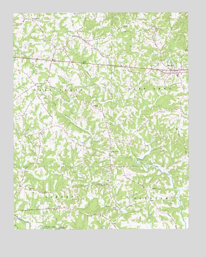
East Bend, NC USGS Topographic Map
Click on map above to begin viewing in our Map Viewer.

This topographic map contains these locations and features:
Feature Name Type Latitude Longitude GNIS ID View Map
BaltimorePopulated PlaceN36.1479°W80.5298°1731800View Map
Baltimore CemeteryCemeteryN36.1482°W80.5273°1731711View Map
Baltimore United Methodist ChurchChurchN36.1482°W80.5267°980510View Map
Brown LakeReservoirN36.1768°W80.6015°1000267View Map
Brown Lake DamDamN36.1768°W80.6015°1000266View Map
Davis Store (historical)LocaleN36.2012°W80.5381°1731806View Map
Deep Creek Primitive Baptist ChurchChurchN36.2490°W80.5817°984068View Map
Doubs Mill (historical)LocaleN36.1579°W80.5178°1731809View Map
East BendPopulated PlaceN36.2165°W80.5126°1020076View Map
East Bend Baptist ChurchChurchN36.2176°W80.5123°1731810View Map
East Bend CemeteryCemeteryN36.2182°W80.5121°1731728View Map
East Bend Elementary SchoolSchoolN36.2140°W80.5076°1006968View Map
East Bend Friends CemeteryCemeteryN36.2124°W80.5112°1731729View Map
East Bend Friends ChurchChurchN36.2149°W80.5126°1731811View Map
East Bend Police DepartmentBuildingN36.2168°W80.5081°2769812View Map
East Bend United Methodist ChurchChurchN36.2165°W80.5026°1731812View Map
East Bend Volunteer Fire DepartmentBuildingN36.2148°W80.5086°2639521View Map
Fall Creek SchoolSchoolN36.2296°W80.5884°984978View Map
Fall Creek Township (historical)CivilN36.2137°W80.6112°1027356View Map
Fall Creek Volunteer Fire DepartmentBuildingN36.2291°W80.5914°2638122View Map
Five ForksPopulated PlaceN36.2287°W80.5942°1731815View Map
Flemmings Mill (historical)LocaleN36.1812°W80.6156°1731816View Map
ForbushPopulated PlaceN36.1979°W80.5742°1006207View Map
Forbush Friends CemeteryCemeteryN36.1982°W80.5737°1731737View Map
Forbush Friends ChurchChurchN36.1990°W80.5737°1731817View Map
Forbush High SchoolSchoolN36.1401°W80.5559°1006969View Map
Hall Creek TabernacleChurchN36.2424°W80.5459°986313View Map
Johnsons School (historical)SchoolN36.1726°W80.5031°1731822View Map
Kings Knob School (historical)SchoolN36.1757°W80.5556°1731823View Map
Little Forbush CreekStreamN36.1512°W80.5701°988645View Map
Loney CreekStreamN36.1474°W80.5062°988875View Map
Mill BranchStreamN36.1254°W80.5026°989887View Map
Mount Bethel Baptist ChurchChurchN36.1926°W80.5209°990322View Map
Mount Bethel CemeteryCemeteryN36.1929°W80.5203°1731761View Map
Mount Carmel CemeteryCemeteryN36.1504°W80.5626°1731762View Map
Mount Carmel Friends ChurchChurchN36.1504°W80.5623°990362View Map
Mount Zion Baptist ChurchChurchN36.1379°W80.5937°990669View Map
Mount Zion CemeteryCemeteryN36.1385°W80.5942°1731767View Map
New Home CemeteryCemeteryN36.2290°W80.5656°1731771View Map
New Home United Methodist ChurchChurchN36.2287°W80.5662°990980View Map
Patterson Grove African Methodist Episcopal Zion ChurchChurchN36.1696°W80.5564°991942View Map
Patterson Grove CemeteryCemeteryN36.1696°W80.5559°1731774View Map
Phillips PondReservoirN36.1335°W80.5277°1000151View Map
Phillips Pond DamDamN36.1335°W80.5281°1000152View Map
Pilot View CemeteryCemeteryN36.1468°W80.6037°1731775View Map
Pilot View Friends ChurchChurchN36.1462°W80.6034°992219View Map
PoindexterPopulated PlaceN36.2307°W80.5878°1731827View Map
Prospect CemeteryCemeteryN36.2249°W80.5589°1731776View Map
Prospect United Methodist ChurchChurchN36.2249°W80.5581°992849View Map
Richmond HillPopulated PlaceN36.2451°W80.6106°1022280View Map
Richmond Hill Baptist ChurchChurchN36.2468°W80.6137°1731828View Map
Richmond Hill CemeteryCemeteryN36.2468°W80.6134°1731779View Map
Shady GrovePopulated PlaceN36.2418°W80.5234°1731830View Map
Shady Grove CemeteryCemeteryN36.2410°W80.5231°1731782View Map
Shady Grove Methodist ChurchChurchN36.2407°W80.5231°994558View Map
Shores Mill (historical)LocaleN36.1260°W80.5923°1731832View Map
SmithtownPopulated PlaceN36.2360°W80.5776°995011View Map
SugartownPopulated PlaceN36.1501°W80.6201°1731835View Map
Sugartown ChurchChurchN36.1485°W80.6134°995661View Map
Town of East BendCivilN36.2167°W80.5087°2406412View Map
Township of East BendCivilN36.2189°W80.5028°1027355View Map
Township of ForbushCivilN36.1403°W80.5160°1027357View Map
Township of South Fall CreekCivilN36.1876°W80.6035°2405114View Map
Tracadia Post Office (historical)Post OfficeN36.1479°W80.5298°1955471View Map
Union CrossPopulated PlaceN36.1843°W80.5978°1731836View Map
Union Cross CemeteryCemeteryN36.1829°W80.6039°1731795View Map
Union Cross Friends ChurchChurchN36.1835°W80.6034°1731837View Map
Union GrovePopulated PlaceN36.2076°W80.6073°1006396View Map
Union Grove Baptist ChurchChurchN36.2087°W80.6090°1731838View Map
Union Grove CemeteryCemeteryN36.2079°W80.6092°1731796View Map
Yadkin County Airport (historical)AirportN36.1421°W80.6092°998037View Map

Note: Coordinates in the location and feature list above are referenced to NAD83 datum.


Copyright (C) 2008-2024 Ryan Niemi / Sunset Dynamics ... All Rights Reserved