TopoQuest Logo
Do you find TopoQuest useful?
Help keep TopoQuest running and adding new maps/features by donating!
Bitcoin:  19c7KJd3qBynnjoSw5npx9KScwjBe4ifkT
Litecoin:  LXs6TkuXGGXo1vDsWCkWVdjQX94eUKd6ui
Home View Maps Find Maps Find Places Resources & Links


Cleveland, Minnesota Topographic Map

USGS Map Title: Cleveland, MN
USGS Map MRC: 44093C7
DRG (GeoTIFF) Download: o44093c7.tif


Neighboring USGS Topographic Map Quads:


  Le Sueur, MN  
44093D8
 

  Saint Thomas, MN  
44093D7
 

  Le Center, MN  
44093D6
 

  Saint Peter, MN  
44093C8
 

  Cleveland, MN  
44093C7
 

  Cordova, MN  
44093C6
 

  Mankato East, MN  
44093B8
 

  Madison Lake, MN  
44093B7
 

  Elysian, MN  
44093B6


Map MRC Location:

N45°
W94°
N45°
W93°
H8 H7 H6 H5 H4 H3 H2 H1
G8 G7 G6 G5 G4 G3 G2 G1
F8 F7 F6 F5 F4 F3 F2 F1
E8 E7 E6 E5 E4 E3 E2 E1
D8 D7 D6 D5 D4 D3 D2 D1
C8 C7 C6 C5 C4 C3 C2 C1
B8 B7 B6 B5 B4 B3 B2 B1
A8 A7 A6 A5 A4 A3 A2 A1
N44°
W94°
N44°
W93°

Cleveland, MN USGS 1:24K Topographic Map Preview:
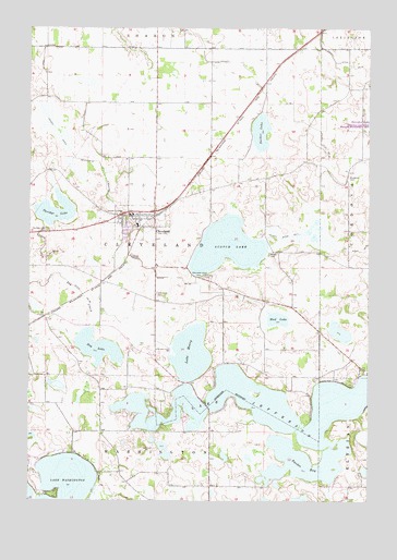
Cleveland, MN USGS Topographic Map
Click on map above to begin viewing in our Map Viewer.

This topographic map contains these locations and features:
Feature Name Type Latitude Longitude GNIS ID View Map
Big Woods and Geldner Saw Mill Historical MarkerParkN44.2764°W93.8097°2063586View Map
Bluegrass CemeteryCemeteryN44.3358°W93.7583°640307View Map
Calvary CemeteryCemeteryN44.3091°W93.8113°640757View Map
Church of ChristChurchN44.3256°W93.8350°2063481View Map
Church of the NativityChurchN44.3236°W93.8411°2063482View Map
City of ClevelandCivilN44.3236°W93.8353°2393560View Map
ClevelandLocaleN44.3261°W93.8286°2063475View Map
ClevelandPopulated PlaceN44.3255°W93.8377°641329View Map
Cleveland CemeteryCemeteryN44.3047°W93.8286°641330View Map
Cleveland City HallBuildingN44.3250°W93.8369°2063478View Map
Cleveland Fire and RescueBuildingN44.3257°W93.8365°2063480View Map
Cleveland Police DepartmentBuildingN44.3252°W93.8374°2758715View Map
Cleveland Post OfficePost OfficeN44.3253°W93.8382°2063476View Map
Cleveland Public LibraryBuildingN44.3250°W93.8369°2063479View Map
Cleveland Public SchoolSchoolN44.3232°W93.8355°2063477View Map
County Ditch Number FiftyoneCanalN44.3669°W93.7630°639158View Map
County Ditch Number Five and ThirtysevenCanalN44.3527°W93.8702°642162View Map
County Ditch Number FortysevenCanalN44.3164°W93.8702°642122View Map
County Ditch Number FourCanalN44.3200°W93.7830°642048View Map
County Ditch Number SixtyCanalN44.3625°W93.7933°642228View Map
County Ditch Number SixtyfiveCanalN44.3114°W93.8311°642256View Map
County Ditch Number ThirtynineCanalN44.3439°W93.7675°642037View Map
Cox Apple OrchardLocaleN44.2906°W93.7811°2651174View Map
Decker LakeLakeN44.3476°W93.7903°642695View Map
Dog LakeLakeN44.2907°W93.8505°642867View Map
Krenik Swine FarmsLocaleN44.2894°W93.8369°2635888View Map
Lake HenryLakeN44.2890°W93.8156°644890View Map
Lake JeffersonLakeN44.2765°W93.7600°645615View Map
Meeker CemeteryCemeteryN44.3152°W93.7872°647743View Map
Mud LakeLakeN44.2983°W93.7838°648215View Map
Our Saviour's Lutheran ChurchChurchN44.3242°W93.8342°2063483View Map
Savidge LakeLakeN44.3265°W93.8666°651247View Map
Savidge Lake CemeteryCemeteryN44.3216°W93.8691°651248View Map
Scotch LakeReservoirN44.3172°W93.8025°651800View Map
Swedes BayBayN44.2577°W93.7716°652926View Map
Township of ClevelandCivilN44.3237°W93.7981°663821View Map
Township of WashingtonCivilN44.2598°W93.8298°665923View Map
Wendelschafer Family CemeteryCemeteryN44.2792°W93.8375°2063564View Map

Note: Coordinates in the location and feature list above are referenced to NAD83 datum.


Copyright (C) 2008-2025 Ryan Niemi / Sunset Dynamics ... All Rights Reserved