TopoQuest Logo
Do you find TopoQuest useful?
Help keep TopoQuest running and adding new maps/features by donating!
Bitcoin:  19c7KJd3qBynnjoSw5npx9KScwjBe4ifkT
Litecoin:  LXs6TkuXGGXo1vDsWCkWVdjQX94eUKd6ui
Home View Maps Find Maps Find Places Resources & Links


Elysian, Minnesota Topographic Map

USGS Map Title: Elysian, MN
USGS Map MRC: 44093B6
DRG (GeoTIFF) Download: o44093b6.tif


Neighboring USGS Topographic Map Quads:


  Cleveland, MN  
44093C7
 

  Cordova, MN  
44093C6
 

  Kilkenny, MN  
44093C5
 

  Madison Lake, MN  
44093B7
 

  Elysian, MN  
44093B6
 

  Waterville, MN  
44093B5
 

  Saint Clair, MN  
44093A7
 

  Janesville, MN  
44093A6
 

  Waseca, MN  
44093A5


Map MRC Location:

N45°
W94°
N45°
W93°
H8 H7 H6 H5 H4 H3 H2 H1
G8 G7 G6 G5 G4 G3 G2 G1
F8 F7 F6 F5 F4 F3 F2 F1
E8 E7 E6 E5 E4 E3 E2 E1
D8 D7 D6 D5 D4 D3 D2 D1
C8 C7 C6 C5 C4 C3 C2 C1
B8 B7 B6 B5 B4 B3 B2 B1
A8 A7 A6 A5 A4 A3 A2 A1
N44°
W94°
N44°
W93°

Elysian, MN USGS 1:24K Topographic Map Preview:
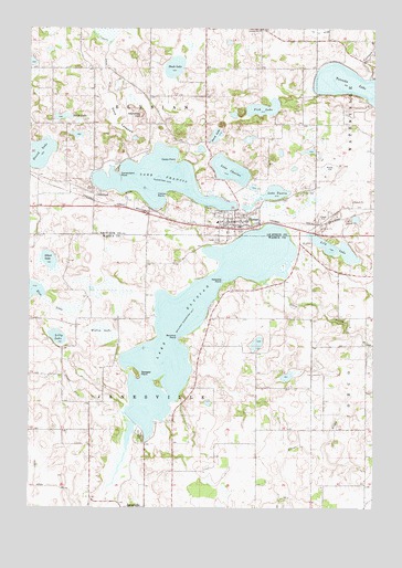
Elysian, MN USGS Topographic Map
Click on map above to begin viewing in our Map Viewer.

This topographic map contains these locations and features:
Feature Name Type Latitude Longitude GNIS ID View Map
Assembly of God ChurchChurchN44.2000°W93.6714°2063474View Map
Bethlehem Lutheran ChurchChurchN44.1986°W93.6736°2063473View Map
Cannonville CemeteryCemeteryN44.2500°W93.6658°640879View Map
Cannonville ChurchChurchN44.2500°W93.6661°640880View Map
Carpenters PointCapeN44.2119°W93.7177°640929View Map
Cedar Hill CemeteryCemeteryN44.1947°W93.6811°641001View Map
Cedar PointCapeN44.2155°W93.6975°641030View Map
City of ElysianCivilN44.2067°W93.6770°2394684View Map
Clarks PointCapeN44.2072°W93.7008°641255View Map
County Ditch Number FiftynineCanalN44.2491°W93.6449°642210View Map
County Ditch Number NineCanalN44.2455°W93.7222°642364View Map
County Ditch Number OneCanalN44.1602°W93.7394°641557View Map
Dehn Family CemeteryCemeteryN44.2486°W93.6875°2063585View Map
Dove LakebedFlatN44.2261°W93.7200°642909View Map
ElysianPopulated PlaceN44.1986°W93.6738°643325View Map
Elysian (historical)LocaleN44.1986°W93.6781°2063467View Map
Elysian Elementary SchoolSchoolN44.1996°W93.6819°2063469View Map
Elysian Fire DepartmentBuildingN44.1990°W93.6729°2063468View Map
Elysian LakeReservoirN44.1734°W93.6901°1776078View Map
Elysian Lake DamDamN44.1466°W93.7102°1776077View Map
Elysian Post OfficePost OfficeN44.1989°W93.6742°2063471View Map
Elysian Public LibraryBuildingN44.1994°W93.6761°2063466View Map
Fish LakeLakeN44.2291°W93.6652°643674View Map
Galler's AirportAirportN44.1871°W93.7094°660139View Map
GreenlandPopulated PlaceN44.2066°W93.7275°654735View Map
Greenland CemeteryCemeteryN44.2083°W93.7267°2063583View Map
Greenland Post Office (historical)Post OfficeN44.2067°W93.7272°2063536View Map
Iosco CreekStreamN44.1844°W93.6649°645442View Map
Irish Mountain OrchardLocaleN44.2489°W93.7489°2651177View Map
Kaupans PointCapeN44.1844°W93.6805°646052View Map
Klondike HillSummitN44.2275°W93.7102°646193View Map
Lake CharlesLakeN44.2131°W93.6776°641113View Map
Lake ElysianPopulated PlaceN44.1486°W93.7136°659830View Map
Lake FrancisLakeN44.2105°W93.7038°643874View Map
Lake TustinLakeN44.2062°W93.6639°653388View Map
Lakeview LakeLakeN44.1734°W93.6901°646440View Map
Lakeview ParkParkN44.1444°W93.7099°2051218View Map
Le Sueur County MuseumBuildingN44.2011°W93.6731°2063465View Map
Lilly LakeLakeN44.1695°W93.7398°646642View Map
Lily LakeLakeN44.1927°W93.6392°646645View Map
Okaman CemeteryCemeteryN44.2103°W93.6333°2063578View Map
Perch LakeLakeN44.2222°W93.6827°649282View Map
Prairie Ridge Golf CourseLocaleN44.1277°W93.7127°2051221View Map
Rice LakeLakeN44.1814°W93.7497°650028View Map
Round LakeLakeN44.2171°W93.7464°650353View Map
Round Lake CemeteryCemeteryN44.2180°W93.7375°2063584View Map
Saint Andrew's ChurchChurchN44.1972°W93.6667°2063472View Map
Savages PointCapeN44.1600°W93.7097°651245View Map
Sextons PointCapeN44.1694°W93.6963°651880View Map
Sibert LakeLakeN44.1897°W93.7431°652005View Map
Silver LakeLakeN44.2269°W93.7383°652047View Map
Steele LakeLakeN44.2399°W93.6978°652599View Map
Township of ElysianCivilN44.2408°W93.7084°664092View Map
Township of JanesvilleCivilN44.1541°W93.7076°664573View Map
Willis LakeSwampN44.1705°W93.7236°654176View Map

Note: Coordinates in the location and feature list above are referenced to NAD83 datum.


Copyright (C) 2008-2024 Ryan Niemi / Sunset Dynamics ... All Rights Reserved