TopoQuest Logo
Do you find TopoQuest useful?
Help keep TopoQuest running and adding new maps/features by donating!
Bitcoin:  19c7KJd3qBynnjoSw5npx9KScwjBe4ifkT
Litecoin:  LXs6TkuXGGXo1vDsWCkWVdjQX94eUKd6ui
Home View Maps Find Maps Find Places Resources & Links


Cleveland Mountain, Montana Topographic Map

USGS Map Title: Cleveland Mountain, MT
USGS Map MRC: 46113E7
DRG (GeoTIFF) Download: o46113e7.tif


Neighboring USGS Topographic Map Quads:


  Davis Point, MT  
46113F8
 

  Elk Mountain, MT  
46113F7
 

  Iris Point, MT  
46113F6
 

  Grayhorse Creek, MT  
46113E8
 

  Cleveland Mountain, MT  
46113E7
 

  Grizzly Point, MT  
46113E6
 

  Corley Gulch, MT  
46113D8
 

  Sawmill Saddle, MT  
46113D7
 

  Quigg Peak, MT  
46113D6


Map MRC Location:

N47°
W114°
N47°
W113°
H8 H7 H6 H5 H4 H3 H2 H1
G8 G7 G6 G5 G4 G3 G2 G1
F8 F7 F6 F5 F4 F3 F2 F1
E8 E7 E6 E5 E4 E3 E2 E1
D8 D7 D6 D5 D4 D3 D2 D1
C8 C7 C6 C5 C4 C3 C2 C1
B8 B7 B6 B5 B4 B3 B2 B1
A8 A7 A6 A5 A4 A3 A2 A1
N46°
W114°
N46°
W113°

Cleveland Mountain, MT USGS 1:24K Topographic Map Preview:
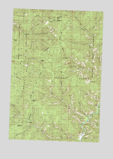
Cleveland Mountain, MT USGS Topographic Map
Click on map above to begin viewing in our Map Viewer.

This topographic map contains these locations and features:
Feature Name Type Latitude Longitude GNIS ID View Map
Ambrose SaddleGapN46.5166°W113.8493°801759View Map
Arasta CreekStreamN46.6021°W113.8520°779107View Map
Bidwell GulchValleyN46.5791°W113.7545°779750View Map
Bitterroot DivideRidgeN46.5821°W113.8365°779956View Map
Butte Cabin CreekStreamN46.5205°W113.7679°780691View Map
Carron CreekStreamN46.5924°W113.7679°780974View Map
Chino CreekStreamN46.5838°W113.7615°781240View Map
Cinnabar PointSummitN46.5663°W113.8040°801863View Map
Cinnabar SaddleGapN46.5766°W113.8301°801758View Map
Cinnamon Bear CreekStreamN46.5224°W113.7670°781284View Map
Cinnamon Bear PointSummitN46.5566°W113.7707°781285View Map
Cinnamon Bear SaddleGapN46.5371°W113.8451°801864View Map
Cleveland MineMineN46.6149°W113.8212°805080View Map
Cleveland MineMineN46.6149°W113.8215°781378View Map
Cleveland MountainSummitN46.6149°W113.8168°806928View Map
Cooney RidgeRidgeN46.6185°W113.8504°781627View Map
Feather GulchValleyN46.5135°W113.8420°783333View Map
Ferret CreekStreamN46.6033°W113.7676°783362View Map
Harrys Flat CampgroundLocaleN46.5327°W113.7523°784588View Map
Harrys GulchValleyN46.5327°W113.7526°784589View Map
Howell CreekStreamN46.5038°W113.7740°785114View Map
Laveck CreekStreamN46.5708°W113.7779°785987View Map
Pat GulchValleyN46.5035°W113.7876°788682View Map
Pawnee GulchValleyN46.5402°W113.7509°788713View Map
Spartan CreekStreamN46.6080°W113.7790°791138View Map
Threemile PointSummitN46.5944°W113.8701°792137View Map
Wahlquist CreekStreamN46.5010°W113.7773°792750View Map
Walkup GulchValleyN46.5405°W113.8037°792765View Map
Welcome Sawmill SaddleGapN46.6166°W113.7929°794519View Map

Note: Coordinates in the location and feature list above are referenced to NAD83 datum.


Copyright (C) 2008-2024 Ryan Niemi / Sunset Dynamics ... All Rights Reserved