TopoQuest Logo
Do you find TopoQuest useful?
Help keep TopoQuest running and adding new maps/features by donating!
Bitcoin:  19c7KJd3qBynnjoSw5npx9KScwjBe4ifkT
Litecoin:  LXs6TkuXGGXo1vDsWCkWVdjQX94eUKd6ui
Home View Maps Find Maps Find Places Resources & Links


Clifton, Ohio Topographic Map

USGS Map Title: Clifton, OH
USGS Map MRC: 39083G7
DRG (GeoTIFF) Download: o39083g7.tif


Neighboring USGS Topographic Map Quads:


  Donnelsville, OH  
39083H8
 

  Springfield, OH  
39083H7
 

  New Moorefield, OH  
39083H6
 

  Yellow Springs, OH  
39083G8
 

  Clifton, OH  
39083G7
 

  South Charleston, OH  
39083G6
 

  Xenia, OH  
39083F8
 

  Cedarville, OH  
39083F7
 

  Jamestown, OH  
39083F6


Map MRC Location:

N40°
W84°
N40°
W83°
H8 H7 H6 H5 H4 H3 H2 H1
G8 G7 G6 G5 G4 G3 G2 G1
F8 F7 F6 F5 F4 F3 F2 F1
E8 E7 E6 E5 E4 E3 E2 E1
D8 D7 D6 D5 D4 D3 D2 D1
C8 C7 C6 C5 C4 C3 C2 C1
B8 B7 B6 B5 B4 B3 B2 B1
A8 A7 A6 A5 A4 A3 A2 A1
N39°
W84°
N39°
W83°

Clifton, OH USGS 1:24K Topographic Map Preview:
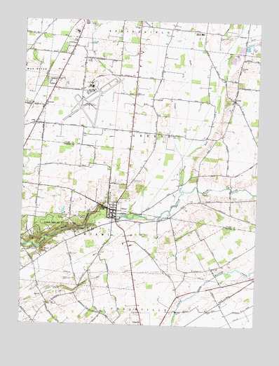
Clifton, OH USGS Topographic Map
Click on map above to begin viewing in our Map Viewer.

This topographic map contains these locations and features:
Feature Name Type Latitude Longitude GNIS ID View Map
Arboretum TrailTrailN39.7917°W83.8588°1963065View Map
Bethel ChurchChurchN39.8323°W83.8691°1037900View Map
Bethel Lutheran CemeteryCemeteryN39.8320°W83.8694°1961187View Map
Blue HoleLakeN39.7951°W83.8388°1963066View Map
Calvary ChurchChurchN39.8728°W83.8133°1038645View Map
Camp BirchLocaleN39.7934°W83.8530°1038664View Map
Camp CliftonLocaleN39.7909°W83.8377°1038677View Map
Camp CooperLocaleN39.7881°W83.8452°1963067View Map
Camp GreeneLocaleN39.7806°W83.8705°1038701View Map
Cedarville University Emergency Medical ServicesBuildingN39.7537°W83.8113°2550774View Map
CliftonPopulated PlaceN39.7970°W83.8255°1048607View Map
Clifton CemeteryCemeteryN39.8020°W83.8302°1963021View Map
Clifton GorgeValleyN39.7989°W83.8316°1039186View Map
Clifton Gorge State Nature PreserveParkN39.7898°W83.8458°1960574View Map
Clifton MillLocaleN39.7942°W83.8258°1963069View Map
Clifton United Presbyterian ChurchChurchN39.7989°W83.8283°1963031View Map
Crawley Field (historical)AirportN39.7792°W83.8597°1083141View Map
Ebenezer CemeteryCemeteryN39.8506°W83.8574°1040047View Map
Emery Chapel CemeteryCemeteryN39.8748°W83.8416°1040191View Map
Emery Chapel United Methodist ChurchChurchN39.8748°W83.8422°1061057View Map
Flying J AirportAirportN39.8147°W83.7576°1082961View Map
Garlough CemeteryCemeteryN39.8564°W83.7591°1040782View Map
Goose CreekStreamN39.8162°W83.7888°1040961View Map
Green Special SchoolSchoolN39.8451°W83.8141°1041099View Map
Grinnell Mill Historic DistrictParkN39.7862°W83.8730°1069144View Map
Horace Mann Memorial MonumentParkN39.7856°W83.8702°1041788View Map
HusteadPopulated PlaceN39.8406°W83.8630°1064882View Map
Hustead Fire DepartmentBuildingN39.8368°W83.8664°2550162View Map
Hustead Post Office (historical)Post OfficeN39.8403°W83.8638°1966413View Map
John Bryan State ParkParkN39.7912°W83.8544°1056362View Map
Lower Picnic AreaLocaleN39.7839°W83.8644°1963073View Map
McClellan CemeteryCemeteryN39.8162°W83.8388°1963026View Map
Miami Township Fire and Rescue Station 2BuildingN39.7957°W83.8270°2549208View Map
North CemeteryCemeteryN39.7548°W83.8116°1043901View Map
North Fork Little Miami RiverStreamN39.8042°W83.7899°1043907View Map
Orton Memorial MonumentParkN39.7973°W83.8383°1084035View Map
Orton Memorial TrailTrailN39.7978°W83.8366°1963074View Map
Orton Picnic AreaLocaleN39.7937°W83.8430°1963075View Map
Peacock AcresPopulated PlaceN39.8595°W83.8402°1051410View Map
Peifer OrchardsLocaleN39.8236°W83.8717°2516118View Map
PitchinPopulated PlaceN39.8428°W83.7624°1049086View Map
Pitchin Post Office (historical)Post OfficeN39.8431°W83.7624°1983749View Map
Pitchin Village Fire DepartmentBuildingN39.8417°W83.7616°2550168View Map
Rainbow RunStreamN39.7948°W83.8188°1048407View Map
Shawnee High SchoolSchoolN39.8706°W83.7808°1046154View Map
South Gorge TrailTrailN39.7881°W83.8530°1963077View Map
Springfield-Beckley Air Guard StationMilitaryN39.8494°W83.8353°2512022View Map
Springfield-Beckley Municipal AirportAirportN39.8431°W83.8436°1083025View Map
Steamboat RockPillarN39.7959°W83.8358°1963078View Map
The NarrowsChannelN39.7978°W83.8296°1963079View Map
Township of GreenCivilN39.8302°W83.7827°1085852View Map
Township of MiamiCivilN39.7956°W83.8731°1086169View Map
Village of CliftonCivilN39.7970°W83.8257°2397648View Map
Wingo Picnic AreaLocaleN39.7903°W83.8563°1963080View Map
Youngs Jersey DairyLocaleN39.8261°W83.8711°2628477View Map

Note: Coordinates in the location and feature list above are referenced to NAD83 datum.


Copyright (C) 2008-2024 Ryan Niemi / Sunset Dynamics ... All Rights Reserved