TopoQuest Logo
Do you find TopoQuest useful?
Help keep TopoQuest running and adding new maps/features by donating!
Bitcoin:  19c7KJd3qBynnjoSw5npx9KScwjBe4ifkT
Litecoin:  LXs6TkuXGGXo1vDsWCkWVdjQX94eUKd6ui
Home View Maps Find Maps Find Places Resources & Links


New Moorefield, Ohio Topographic Map

USGS Map Title: New Moorefield, OH
USGS Map MRC: 39083H6
DRG (GeoTIFF) Download: o39083h6.tif


Neighboring USGS Topographic Map Quads:


  Urbana West, OH  
40083A7
 

  Urbana East, OH  
40083A6
 

  Mechanicsburg, OH  
40083A5
 

  Springfield, OH  
39083H7
 

  New Moorefield, OH  
39083H6
 

  South Vienna, OH  
39083H5
 

  Clifton, OH  
39083G7
 

  South Charleston, OH  
39083G6
 

  Florence, OH  
39083G5


Map MRC Location:

N40°
W84°
N40°
W83°
H8 H7 H6 H5 H4 H3 H2 H1
G8 G7 G6 G5 G4 G3 G2 G1
F8 F7 F6 F5 F4 F3 F2 F1
E8 E7 E6 E5 E4 E3 E2 E1
D8 D7 D6 D5 D4 D3 D2 D1
C8 C7 C6 C5 C4 C3 C2 C1
B8 B7 B6 B5 B4 B3 B2 B1
A8 A7 A6 A5 A4 A3 A2 A1
N39°
W84°
N39°
W83°

New Moorefield, OH USGS 1:24K Topographic Map Preview:
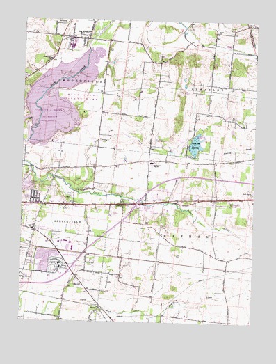
New Moorefield, OH USGS Topographic Map
Click on map above to begin viewing in our Map Viewer.

This topographic map contains these locations and features:
Feature Name Type Latitude Longitude GNIS ID View Map
Asbury Chapel CemeteryCemeteryN39.9626°W83.6494°1961162View Map
Asbury ChurchChurchN39.9617°W83.6502°1037503View Map
Asbury Church (historical)ChurchN39.9620°W83.6502°1051365View Map
Beaver Valley CampgroundLocaleN39.9237°W83.6791°1083531View Map
Brookside Park Mobile Home ParkPopulated PlaceN39.9498°W83.6794°1083537View Map
Buck Creek State ParkParkN39.9678°W83.7208°1085198View Map
Cherry Point Mobile Home ParkPopulated PlaceN39.9106°W83.7416°1083538View Map
Clarence J Brown DamDamN39.9501°W83.7466°1077656View Map
Clarence J Brown ReservoirReservoirN39.9599°W83.7292°1080470View Map
Clark County FairgroundsLocaleN39.8987°W83.7305°1051371View Map
Clark LakeReservoirN39.9489°W83.6569°1078388View Map
Clark Lake DamDamN39.9474°W83.6606°1078387View Map
Clark Lake Wildlife AreaParkN39.9512°W83.6538°1039141View Map
Crawford Mobile Home ParkPopulated PlaceN39.9264°W83.6546°1083534View Map
Fletcher ChapelChurchN39.8937°W83.6963°1080427View Map
Fletcher Chapel CemeteryCemeteryN39.8937°W83.6955°1051377View Map
Foley CemeteryCemeteryN39.9878°W83.7021°1040541View Map
Garden AcresPopulated PlaceN39.9259°W83.7433°1051378View Map
Graybill CemeteryCemeteryN39.9578°W83.7477°1041089View Map
HarmonyPopulated PlaceN39.9228°W83.6971°1056312View Map
Harmony Estates Mobile Home ParkPopulated PlaceN39.9276°W83.6699°1083536View Map
Harmony Post Office (historical)Post OfficeN39.9223°W83.6971°1966412View Map
Hidden Oakes CampgroundLocaleN39.9251°W83.6788°1083533View Map
Holiday HillsPopulated PlaceN39.9306°W83.7471°1083530View Map
Hollandia ViewPopulated PlaceN39.9239°W83.6416°1052364View Map
Interchange 59CrossingN39.8967°W83.7230°1051384View Map
Interchange 62CrossingN39.9239°W83.6877°1051385View Map
Kepes Flying FieldAirportN39.9236°W83.6646°1083024View Map
Lakeview AcresPopulated PlaceN39.9484°W83.6627°1051392View Map
Lakeview TrailTrailN39.9681°W83.7310°1961190View Map
Melody Cruise-InLocaleN39.9211°W83.7289°2633534View Map
Mitchell Hills Country ClubLocaleN39.9981°W83.7324°1083529View Map
Moorefield Township HallBuildingN39.9920°W83.7163°1051399View Map
New MoorefieldPopulated PlaceN39.9920°W83.7171°1065127View Map
New Moorefield Post Office (historical)Post OfficeN39.9917°W83.7166°1984364View Map
New Moorefield SchoolSchoolN39.9926°W83.7188°1084839View Map
Newlove School (historical)SchoolN39.9114°W83.6741°1051400View Map
Northeastern High SchoolSchoolN39.9412°W83.6808°1043981View Map
Ohio State Highway Patrol - Springfield Patrol PostBuildingN39.9064°W83.7291°1083535View Map
Oxtoby (historical)Populated PlaceN39.9017°W83.6955°1067499View Map
Oxtoby Post Office (historical)Post OfficeN39.9014°W83.6958°1983747View Map
Pleasant Hill CemeteryCemeteryN39.9828°W83.7374°1961174View Map
Pleasant Hill ChurchChurchN39.9831°W83.7371°1044556View Map
Prairie Road Fen State Nature PreserveParkN39.9945°W83.7063°1961191View Map
Primeohio Corporate ParkLocaleN39.9084°W83.7244°1083528View Map
Reid Elementary SchoolSchoolN39.9131°W83.7438°1051411View Map
Reid Memorial ParkParkN39.9514°W83.7408°1044936View Map
Rose Hill CemeteryCemeteryN39.8903°W83.7191°1045185View Map
Sinking CreekStreamN39.9303°W83.7238°1046302View Map
Sinking Creek Baptist ChurchChurchN39.9392°W83.7105°1058016View Map
South Vienna CemeteryCemeteryN39.9287°W83.6258°1046499View Map
Springfield Sand and Gravel PitMineN39.9014°W83.7381°2633442View Map
Springfield Township Fire and Rescue Station 2 Garden AcresBuildingN39.9235°W83.7432°2550163View Map
Summerford Post Office (historical)Post OfficeN39.9334°W83.6596°2030254View Map
The KnobsSummitN39.9706°W83.6646°1051389View Map
ThorpsPopulated PlaceN39.8801°W83.7071°1061686View Map
Titus CemeteryCemeteryN39.9158°W83.6832°1047072View Map
Township of HarmonyCivilN39.8986°W83.6280°1085853View Map
Township of MoorefieldCivilN39.9884°W83.7410°1085856View Map
Tuttle CemeteryCemeteryN39.9028°W83.6666°1047234View Map
Tuttle CemeteryCemeteryN39.9331°W83.7213°1047235View Map
Vernon CemeteryCemeteryN39.9956°W83.6466°1047441View Map
Yale CemeteryCemeteryN39.9258°W83.7257°1048171View Map
Yeazel School (historical)SchoolN39.9614°W83.7010°1051423View Map

Note: Coordinates in the location and feature list above are referenced to NAD83 datum.


Copyright (C) 2008-2024 Ryan Niemi / Sunset Dynamics ... All Rights Reserved