TopoQuest Logo
Do you find TopoQuest useful?
Help keep TopoQuest running and adding new maps/features by donating!
Bitcoin:  19c7KJd3qBynnjoSw5npx9KScwjBe4ifkT
Litecoin:  LXs6TkuXGGXo1vDsWCkWVdjQX94eUKd6ui
Home View Maps Find Maps Find Places Resources & Links


South Charleston, Ohio Topographic Map

USGS Map Title: South Charleston, OH
USGS Map MRC: 39083G6
DRG (GeoTIFF) Download: o39083g6.tif


Neighboring USGS Topographic Map Quads:


  Springfield, OH  
39083H7
 

  New Moorefield, OH  
39083H6
 

  South Vienna, OH  
39083H5
 

  Clifton, OH  
39083G7
 

  South Charleston, OH  
39083G6
 

  Florence, OH  
39083G5
 

  Cedarville, OH  
39083F7
 

  Jamestown, OH  
39083F6
 

  Jeffersonville, OH  
39083F5


Map MRC Location:

N40°
W84°
N40°
W83°
H8 H7 H6 H5 H4 H3 H2 H1
G8 G7 G6 G5 G4 G3 G2 G1
F8 F7 F6 F5 F4 F3 F2 F1
E8 E7 E6 E5 E4 E3 E2 E1
D8 D7 D6 D5 D4 D3 D2 D1
C8 C7 C6 C5 C4 C3 C2 C1
B8 B7 B6 B5 B4 B3 B2 B1
A8 A7 A6 A5 A4 A3 A2 A1
N39°
W84°
N39°
W83°

South Charleston, OH USGS 1:24K Topographic Map Preview:
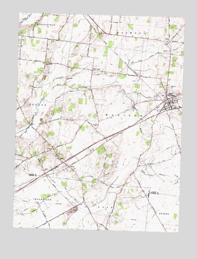
South Charleston, OH USGS Topographic Map
Click on map above to begin viewing in our Map Viewer.

This topographic map contains these locations and features:
Feature Name Type Latitude Longitude GNIS ID View Map
Bloxom CemeteryCemeteryN39.7842°W83.7277°1038132View Map
Briggs School (historical)SchoolN39.7881°W83.6577°1051367View Map
Buffenbarger CemeteryCemeteryN39.8373°W83.7121°1038501View Map
CortsvillePopulated PlaceN39.7964°W83.7210°1060998View Map
Dolly VardenPopulated PlaceN39.8426°W83.6924°1064546View Map
Dublin School (historical)SchoolN39.8131°W83.7235°1051372View Map
First Presbyterian Church of South CharlestonChurchN39.8259°W83.6358°1051376View Map
Green Plain Monthly MeetinghouseChurchN39.8098°W83.6910°1071540View Map
Greenlawn CemeteryCemeteryN39.8342°W83.6349°1041135View Map
LisbonPopulated PlaceN39.8609°W83.6352°1048922View Map
Lisbon AirfieldAirportN39.8644°W83.6322°1083022View Map
Lisbon CemeteryCemeteryN39.8592°W83.6394°1042612View Map
Lisbon ForkStreamN39.8364°W83.6749°1042614View Map
Locust Hills Golf CourseLocaleN39.8384°W83.7430°1051394View Map
Madison Township Fire Department and Emergency Medical ServicesBuildingN39.8260°W83.6395°2550494View Map
Methodist CemeteryCemeteryN39.8253°W83.6338°1961170View Map
Miami View Elementary SchoolSchoolN39.8292°W83.6399°1051396View Map
Old Quaker CemeteryCemeteryN39.8101°W83.6907°1044122View Map
Pleasant Grove CemeteryCemeteryN39.8456°W83.7285°1961173View Map
Pleasant Grove ChurchChurchN39.8453°W83.7280°1044532View Map
SelmaPopulated PlaceN39.7867°W83.7085°1065299View Map
Selma ChurchChurchN39.7909°W83.7152°1046088View Map
Selma Methodist Episcopal CemeteryCemeteryN39.7911°W83.7167°1961175View Map
Selma Post OfficePost OfficeN39.7862°W83.7083°1966298View Map
South CharlestonPopulated PlaceN39.8253°W83.6344°1065347View Map
South Charleston Historic DistrictParkN39.8251°W83.6349°1069091View Map
South Charleston Police DepartmentBuildingN39.8245°W83.6349°2733077View Map
South Charleston Post Office (historical)Post OfficeN39.8251°W83.6346°1966285View Map
South Charleston United Methodist ChurchChurchN39.8253°W83.6341°1051414View Map
Southeastern High SchoolSchoolN39.8256°W83.6324°1051415View Map
Township of MadisonCivilN39.8148°W83.6455°1085854View Map
Village of South CharlestonCivilN39.8249°W83.6416°2399844View Map

Note: Coordinates in the location and feature list above are referenced to NAD83 datum.


Copyright (C) 2008-2025 Ryan Niemi / Sunset Dynamics ... All Rights Reserved