TopoQuest Logo
Do you find TopoQuest useful?
Help keep TopoQuest running and adding new maps/features by donating!
Bitcoin:  19c7KJd3qBynnjoSw5npx9KScwjBe4ifkT
Litecoin:  LXs6TkuXGGXo1vDsWCkWVdjQX94eUKd6ui
Home View Maps Find Maps Find Places Resources & Links


Cloverdale, Michigan Topographic Map

USGS Map Title: Cloverdale, MI
USGS Map MRC: 42085E4
DRG (GeoTIFF) Download: o42085e4.tif


Neighboring USGS Topographic Map Quads:


  Bowens Mill, MI  
42085F5
 

  Middleville, MI  
42085F4
 

  Hastings, MI  
42085F3
 

  Orangeville, MI  
42085E5
 

  Cloverdale, MI  
42085E4
 

  Dowling, MI  
42085E3
 

  Kalamazoo NE, MI  
42085D5
 

  Delton, MI  
42085D4
 

  Banfield, MI  
42085D3


Map MRC Location:

N43°
W86°
N43°
W85°
H8 H7 H6 H5 H4 H3 H2 H1
G8 G7 G6 G5 G4 G3 G2 G1
F8 F7 F6 F5 F4 F3 F2 F1
E8 E7 E6 E5 E4 E3 E2 E1
D8 D7 D6 D5 D4 D3 D2 D1
C8 C7 C6 C5 C4 C3 C2 C1
B8 B7 B6 B5 B4 B3 B2 B1
A8 A7 A6 A5 A4 A3 A2 A1
N42°
W86°
N42°
W85°

Cloverdale, MI USGS 1:24K Topographic Map Preview:
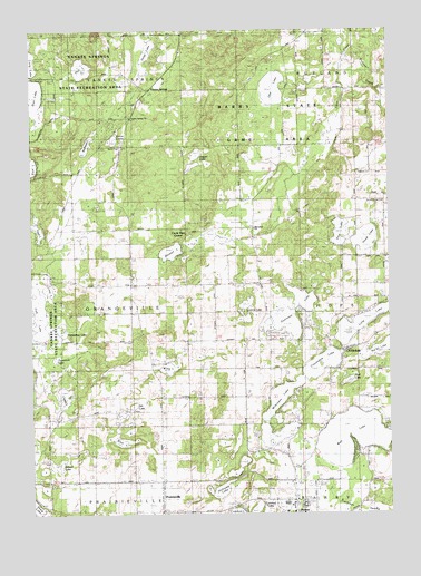
Cloverdale, MI USGS Topographic Map
Click on map above to begin viewing in our Map Viewer.

This topographic map contains these locations and features:
Feature Name Type Latitude Longitude GNIS ID View Map
Adams LakeLakeN42.5126°W85.4913°619823View Map
Barry State Game AreaParkN42.5978°W85.4333°620651View Map
Barry Township Police DepartmentBuildingN42.5001°W85.4053°2737434View Map
Bernard Historical MuseumBuildingN42.5033°W85.4236°2572801View Map
Blue LakeLakeN42.5187°W85.4694°621630View Map
Brush Ridge CemeteryCemeteryN42.5803°W85.3756°622146View Map
Brush Ridge SchoolSchoolN42.5806°W85.3867°622147View Map
Bullhead LakeLakeN42.5945°W85.4817°622230View Map
Cave CreekStreamN42.5398°W85.4915°2652255View Map
Circle Pine CenterPopulated PlaceN42.5739°W85.4606°623317View Map
CloverdalePopulated PlaceN42.5425°W85.3903°2109229View Map
Cloverdale LakeLakeN42.5403°W85.3955°623497View Map
Cloverdale Post OfficePost OfficeN42.5433°W85.3903°2572812View Map
Cloverdale Station (historical)LocaleN42.5431°W85.3903°2572811View Map
Crystal LakeLakeN42.5314°W85.4889°2109232View Map
Dagget LakeLakeN42.5929°W85.4423°624270View Map
Deep LakeLakeN42.6197°W85.4586°624449View Map
Delton District LibraryBuildingN42.5033°W85.4083°2572800View Map
Delton Fire DepartmentBuildingN42.5001°W85.4055°2636229View Map
Delton-Kellogg High SchoolSchoolN42.5019°W85.4092°2572791View Map
Delton-Kellogg Middle SchoolSchoolN42.5028°W85.4114°2572792View Map
Faith United Methodist ChurchChurchN42.5036°W85.3997°2572799View Map
Fawn LakeLakeN42.5736°W85.4972°2109233View Map
Fish LakeLakeN42.5524°W85.4978°626043View Map
Guernsey LakeLakeN42.5516°W85.4090°627496View Map
Guernsey Lake Mobile Home CourtPopulated PlaceN42.5528°W85.4061°2572803View Map
Hall LakeLakeN42.6152°W85.4818°627646View Map
Head LakeLakeN42.5710°W85.3832°628024View Map
Holcomb LakeLakeN42.5064°W85.4342°628410View Map
Horseshoe LakeLakeN42.5467°W85.4894°628608View Map
Inter Lakes Baptist ChurchChurchN42.5100°W85.4083°2572798View Map
Jesuit CemeteryCemeteryN42.5953°W85.4695°629272View Map
Jones LakeLakeN42.5197°W85.4177°2572793View Map
Jones Lake CampgroundLocaleN42.5208°W85.4208°2572802View Map
Lime LakeLakeN42.5582°W85.4941°630426View Map
Long LakeLakeN42.5528°W85.3786°630972View Map
Loomis LakeLakeN42.5510°W85.4245°631031View Map
McCallum CemeteryCemeteryN42.5744°W85.4222°2572217View Map
McCallum ChurchChurchN42.5736°W85.4220°631811View Map
Mercy Ambulance Service DeltonBuildingN42.5001°W85.4055°2662114View Map
Mud LakeLakeN42.5347°W85.3889°2109230View Map
Mullenhurst Golf CourseLocaleN42.5722°W85.4819°2572804View Map
Number Twenty-one LakeLakeN42.5424°W85.3781°633435View Map
Orr LakeLakeN42.5283°W85.4639°2109231View Map
Otis LakeLakeN42.6098°W85.4152°634152View Map
Otis SanctuaryParkN42.6042°W85.3856°2572694View Map
Pine LakeLakeN42.5726°W85.3921°634958View Map
PrairievillePopulated PlaceN42.5048°W85.4550°635397View Map
Prairieville Bible ChurchChurchN42.5056°W85.4550°2572805View Map
Prairieville Post Office (historical)Post OfficeN42.5047°W85.4550°2572366View Map
Prairieville Township CemeteryCemeteryN42.5078°W85.4517°2572241View Map
Prairieville Township Police DepartmentBuildingN42.5075°W85.4545°2737430View Map
Snow LakeLakeN42.5967°W85.4708°638203View Map
Stewart LakeLakeN42.5678°W85.4512°638834View Map
Tamarack LakeLakeN42.5402°W85.4921°1614564View Map
Township of OrangevilleCivilN42.5517°W85.4845°1626855View Map
Tyden CreekStreamN42.5874°W85.4077°2745589View Map
Wall LakeLakeN42.5197°W85.3888°1615707View Map
Wiley LakeLakeN42.5376°W85.4527°1616475View Map
Wilkinson LakeLakeN42.5206°W85.4127°1616486View Map
WLLA-TV (Kalamazoo)TowerN42.5709°W85.4697°1625537View Map
WUHQ-TV (Battle Creek)TowerN42.5709°W85.4697°1625529View Map
Yankee Spring Post Office (historical)Post OfficeN42.6097°W85.4581°2572359View Map
Yankee SpringsLocaleN42.6097°W85.4581°2109234View Map
Yankee Springs CemeteryCemeteryN42.6028°W85.4656°2572242View Map
Yankee Springs ChurchChurchN42.6028°W85.4650°1616868View Map
Yankee Springs Inn Historical MarkerParkN42.6051°W85.4631°2564502View Map
Yankee Springs Recreation AreaParkN42.6128°W85.4911°1616870View Map

Note: Coordinates in the location and feature list above are referenced to NAD83 datum.


Copyright (C) 2008-2025 Ryan Niemi / Sunset Dynamics ... All Rights Reserved