TopoQuest Logo
Do you find TopoQuest useful?
Help keep TopoQuest running and adding new maps/features by donating!
Bitcoin:  19c7KJd3qBynnjoSw5npx9KScwjBe4ifkT
Litecoin:  LXs6TkuXGGXo1vDsWCkWVdjQX94eUKd6ui
Home View Maps Find Maps Find Places Resources & Links


Dowling, Michigan Topographic Map

USGS Map Title: Dowling, MI
USGS Map MRC: 42085E3
DRG (GeoTIFF) Download: o42085e3.tif


Neighboring USGS Topographic Map Quads:


  Middleville, MI  
42085F4
 

  Hastings, MI  
42085F3
 

  Woodland, MI  
42085F2
 

  Cloverdale, MI  
42085E4
 

  Dowling, MI  
42085E3
 

  Maple Grove, MI  
42085E2
 

  Delton, MI  
42085D4
 

  Banfield, MI  
42085D3
 

  Bedford, MI  
42085D2


Map MRC Location:

N43°
W86°
N43°
W85°
H8 H7 H6 H5 H4 H3 H2 H1
G8 G7 G6 G5 G4 G3 G2 G1
F8 F7 F6 F5 F4 F3 F2 F1
E8 E7 E6 E5 E4 E3 E2 E1
D8 D7 D6 D5 D4 D3 D2 D1
C8 C7 C6 C5 C4 C3 C2 C1
B8 B7 B6 B5 B4 B3 B2 B1
A8 A7 A6 A5 A4 A3 A2 A1
N42°
W86°
N42°
W85°

Dowling, MI USGS 1:24K Topographic Map Preview:
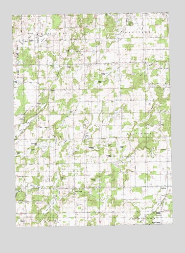
Dowling, MI USGS Topographic Map
Click on map above to begin viewing in our Map Viewer.

This topographic map contains these locations and features:
Feature Name Type Latitude Longitude GNIS ID View Map
Aurohn LakeLakeN42.5485°W85.3019°2109225View Map
Baltimore ChurchChurchN42.5731°W85.2892°2109226View Map
Barry CountyCivilN42.5950°W85.3090°1622950View Map
Bawker LakeLakeN42.5478°W85.3514°620774View Map
Big Cedar LakeLakeN42.5120°W85.3478°621300View Map
Brewster LakeLakeN42.5403°W85.2972°621943View Map
Bristol CornersLocaleN42.5003°W85.2586°622008View Map
Cedar CreekPopulated PlaceN42.5203°W85.3275°622891View Map
Cedar Creek Bible ChurchChurchN42.5189°W85.3272°2572807View Map
Cedar Creek CemeteryCemeteryN42.5125°W85.3267°622907View Map
Cedarcreek Post Office (historical)Post OfficeN42.5203°W85.3275°2572389View Map
Clear LakeLakeN42.5098°W85.2694°623412View Map
Country ChapelChurchN42.5225°W85.2525°2572810View Map
Cox LakeLakeN42.5605°W85.3359°623935View Map
Doud SchoolSchoolN42.5364°W85.3283°624819View Map
DowlingPopulated PlaceN42.5225°W85.2531°624850View Map
Dowling CemeteryCemeteryN42.5442°W85.2515°624851View Map
Dowling Census Designated PlaceCensusN42.5227°W85.2532°2583734View Map
Dowling Post OfficePost OfficeN42.5219°W85.2531°2572809View Map
Dowling Public LibraryBuildingN42.5225°W85.2581°2572718View Map
Dowling SchoolSchoolN42.5342°W85.2544°624852View Map
Faith TempleChurchN42.6136°W85.3592°2109228View Map
Gesler LakeLakeN42.5446°W85.3638°626765View Map
Gregory SchoolSchoolN42.6031°W85.2903°627409View Map
Hendershott SchoolSchoolN42.5725°W85.2900°628100View Map
Hinds SchoolSchoolN42.5731°W85.3233°628342View Map
Hope Township District Number Four School Historical MarkerParkN42.5733°W85.3233°2564494View Map
Hope United Methodist ChurchChurchN42.6122°W85.2706°2572719View Map
Horseshoe LakeLakeN42.5495°W85.3547°628609View Map
Howard LakeLakeN42.5271°W85.3090°628695View Map
Kellie CreekStreamN42.5809°W85.2525°629521View Map
Larabee LakeLakeN42.5507°W85.3337°630160View Map
Lily LakeLakeN42.6247°W85.2981°630403View Map
Little Cedar LakeLakeN42.5279°W85.3414°630593View Map
Little Pine LakeLakeN42.5526°W85.3173°630732View Map
McOmber SchoolSchoolN42.5725°W85.2644°632015View Map
Mud LakeLakeN42.5410°W85.2648°632932View Map
Myers LakeLakeN42.5841°W85.3093°633190View Map
Newton LakeLakeN42.5895°W85.2997°633381View Map
North Branch Cedar CreekStreamN42.5956°W85.2542°633495View Map
Perch LakeLakeN42.5855°W85.3723°634618View Map
Pierce LakeLakeN42.5449°W85.2908°634829View Map
PodunkPopulated PlaceN42.6089°W85.3583°1617794View Map
Podunk LakeLakeN42.6112°W85.3499°635159View Map
Pritchardville Post Office (historical)Post OfficeN42.5431°W85.2792°2572365View Map
SchultzPopulated PlaceN42.5806°W85.3464°1617839View Map
Shallow LakeLakeN42.5237°W85.3605°637648View Map
Shultz Post Office (historical)Post OfficeN42.5806°W85.3464°2572360View Map
Shultz SchoolSchoolN42.5736°W85.3561°637862View Map
Shultz Station (historical)LocaleN42.5803°W85.3461°2572683View Map
Star SchoolSchoolN42.6136°W85.2711°638740View Map
Tanner CemeteryCemeteryN42.6170°W85.3334°2572222View Map
Tanner LakeLakeN42.6031°W85.3280°1614586View Map
Tanner SchoolSchoolN42.6095°W85.3283°1614587View Map
Tillotson LakeLakeN42.5940°W85.3397°1614863View Map
Township of HopeCivilN42.5518°W85.3670°1626488View Map
Twin LakesLakeN42.5967°W85.3316°1615254View Map
Vickery LandingPopulated PlaceN42.5039°W85.2714°1615570View Map
Weeks SchoolSchoolN42.5348°W85.2794°1615967View Map
Wesleyan Conference GroundsLocaleN42.6186°W85.2806°2109227View Map
Whitefish LakeLakeN42.5457°W85.3100°1616350View Map
Zigler LakeLakeN42.5676°W85.3314°1616928View Map

Note: Coordinates in the location and feature list above are referenced to NAD83 datum.


Copyright (C) 2008-2025 Ryan Niemi / Sunset Dynamics ... All Rights Reserved