TopoQuest Logo
Do you find TopoQuest useful?
Help keep TopoQuest running and adding new maps/features by donating!
Bitcoin:  19c7KJd3qBynnjoSw5npx9KScwjBe4ifkT
Litecoin:  LXs6TkuXGGXo1vDsWCkWVdjQX94eUKd6ui
Home View Maps Find Maps Find Places Resources & Links


Coburg, Oregon Topographic Map

USGS Map Title: Coburg, OR
USGS Map MRC: 44123B1
DRG (GeoTIFF) Download: o44123b1.tif


Neighboring USGS Topographic Map Quads:


  Harrisburg, OR  
44123C2
 

  Indian Head, OR  
44123C1
 

  Union Point, OR  
44122C8
 

  Junction City, OR  
44123B2
 

  Coburg, OR  
44123B1
 

  Mohawk, OR  
44122B8
 

  Eugene West, OR  
44123A2
 

  Eugene East, OR  
44123A1
 

  Springfield, OR  
44122A8


Map MRC Location:

N45°
W124°
N45°
W123°
H8 H7 H6 H5 H4 H3 H2 H1
G8 G7 G6 G5 G4 G3 G2 G1
F8 F7 F6 F5 F4 F3 F2 F1
E8 E7 E6 E5 E4 E3 E2 E1
D8 D7 D6 D5 D4 D3 D2 D1
C8 C7 C6 C5 C4 C3 C2 C1
B8 B7 B6 B5 B4 B3 B2 B1
A8 A7 A6 A5 A4 A3 A2 A1
N44°
W124°
N44°
W123°

Coburg, OR USGS 1:24K Topographic Map Preview:
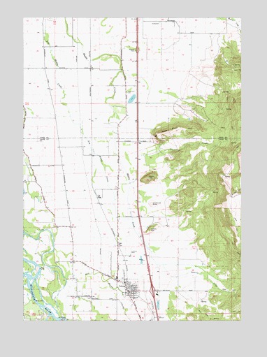
Coburg, OR USGS Topographic Map
Click on map above to begin viewing in our Map Viewer.

This topographic map contains these locations and features:
Feature Name Type Latitude Longitude GNIS ID View Map
Anderson (historical)LocaleN44.1337°W123.0581°1166339View Map
Bowers (historical)LocaleN44.2304°W123.0845°1166733View Map
Briggs Airport (historical)AirportN44.1521°W123.0648°1158827View Map
Canterbury CreekStreamN44.1415°W123.1012°1161054View Map
Cartwright SloughStreamN44.1829°W123.1129°1161837View Map
Centennial ButteSummitN44.1731°W123.0525°1136137View Map
City of CoburgCivilN44.1394°W123.0589°2409497View Map
CoburgPopulated PlaceN44.1371°W123.0665°1119067View Map
Coburg City HallBuildingN44.1373°W123.0660°2661191View Map
Coburg DivisionCivilN44.1605°W123.0599°1937982View Map
Coburg Elementary SchoolSchoolN44.1427°W123.0724°1638788View Map
Coburg Municipal CourtBuildingN44.1373°W123.0660°2661140View Map
Coburg Police DepartmentBuildingN44.1372°W123.0658°2737766View Map
Coburg Post OfficePost OfficeN44.1393°W123.0670°1165070View Map
Coburg Public Works ShopBuildingN44.1373°W123.0659°2661179View Map
Coburg Rural Fire Protection DistrictBuildingN44.1417°W123.0724°2576986View Map
Coburg Water Treatment PlantLocaleN44.1326°W123.0706°2660827View Map
Coleman CreekStreamN44.1929°W123.0606°1119135View Map
Daniels CreekStreamN44.1482°W123.0501°1119681View Map
Dry Muddy CreekStreamN44.2498°W123.1134°1120180View Map
Greer AirportAirportN44.1937°W123.0728°2645995View Map
Hileman Landing Boat RampLocaleN44.1426°W123.1249°2668287View Map
Hileman Landing County ParkParkN44.1401°W123.1248°1161836View Map
Lenon HillSummitN44.1625°W123.0533°1136473View Map
McKenzie RiverStreamN44.1257°W123.1056°1136527View Map
Mill SloughStreamN44.1415°W123.1012°1124178View Map
Norma Pfeiffer ParkParkN44.1393°W123.0656°1638787View Map
Oak Grove Safety Rest AreaLocaleN44.2373°W123.0595°1161839View Map
Palos Post Office (historical)Post OfficeN44.2035°W123.0926°1164578View Map
Pine Post Office (historical)Post OfficeN44.2098°W123.1073°1164598View Map
Priceboro (historical)LocaleN44.2498°W123.0873°1130209View Map
Rock HillSummitN44.1839°W123.0546°1126188View Map
West Point AirportAirportN44.1978°W123.0556°1161838View Map
West Point CemeteryCemeteryN44.2192°W123.0669°1158549View Map
West Point HillSummitN44.2032°W123.0284°1128890View Map
Wilkins (historical)LocaleN44.1935°W123.0870°1638789View Map

Note: Coordinates in the location and feature list above are referenced to NAD83 datum.


Copyright (C) 2008-2025 Ryan Niemi / Sunset Dynamics ... All Rights Reserved