TopoQuest Logo
Do you find TopoQuest useful?
Help keep TopoQuest running and adding new maps/features by donating!
Bitcoin:  19c7KJd3qBynnjoSw5npx9KScwjBe4ifkT
Litecoin:  LXs6TkuXGGXo1vDsWCkWVdjQX94eUKd6ui
Home View Maps Find Maps Find Places Resources & Links


Colcord, Oklahoma Topographic Map

USGS Map Title: Colcord, OK
USGS Map MRC: 36094C6
DRG (GeoTIFF) Download: o36094c6.tif


Neighboring USGS Topographic Map Quads:


  Jay, OK  
36094D7
 

  Sycamore, OK  
36094D6
 

  Colcord NE, AR  
36094D5
 

  Lake Eucha East, OK  
36094C7
 

  Colcord, OK  
36094C6
 

  Cherokee City, AR  
36094C5
 

  Kansas, OK  
36094B7
 

  Siloam Springs NW, OK  
36094B6
 

  Siloam Springs, AR  
36094B5


Map MRC Location:

N37°
W95°
N37°
W94°
H8 H7 H6 H5 H4 H3 H2 H1
G8 G7 G6 G5 G4 G3 G2 G1
F8 F7 F6 F5 F4 F3 F2 F1
E8 E7 E6 E5 E4 E3 E2 E1
D8 D7 D6 D5 D4 D3 D2 D1
C8 C7 C6 C5 C4 C3 C2 C1
B8 B7 B6 B5 B4 B3 B2 B1
A8 A7 A6 A5 A4 A3 A2 A1
N36°
W95°
N36°
W94°

Colcord, OK USGS 1:24K Topographic Map Preview:
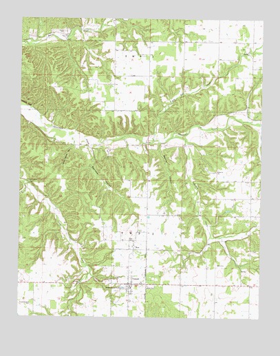
Colcord, OK USGS Topographic Map
Click on map above to begin viewing in our Map Viewer.

This topographic map contains these locations and features:
Feature Name Type Latitude Longitude GNIS ID View Map
Beamer HollowValleyN36.3237°W94.6783°1089897View Map
Beartoter HollowValleyN36.3212°W94.7130°1089922View Map
Beck CemeteryCemeteryN36.2723°W94.6472°1089952View Map
Bethel ChurchChurchN36.3115°W94.6477°1090052View Map
Cherokee CreekStreamN36.3254°W94.6719°76598View Map
Cherokee CreekStreamN36.3254°W94.6719°1091239View Map
Cloud CreekCivilN36.2989°W94.7388°2631091View Map
Cloud Creek ChurchChurchN36.3073°W94.7458°1091480View Map
ColcordPopulated PlaceN36.2642°W94.6930°1091553View Map
Colcord Elementary SchoolSchoolN36.2607°W94.6944°1790609View Map
Colcord Fire DepartmentBuildingN36.2643°W94.6808°2656804View Map
Colcord High SchoolSchoolN36.2632°W94.6924°1790300View Map
Colcord Police DepartmentBuildingN36.2643°W94.6918°2757502View Map
Crazy Nance HollowValleyN36.3245°W94.7230°1091810View Map
Eagles BluffCliffN36.3390°W94.7472°1092336View Map
Hog Eye CreekStreamN36.3242°W94.6802°1093824View Map
O'Field CemeteryCemeteryN36.3695°W94.7283°1096177View Map
Piney ChurchChurchN36.3676°W94.7263°1096676View Map
RowPopulated PlaceN36.2787°W94.6905°1100801View Map
Row CemeteryCemeteryN36.2827°W94.6907°1097513View Map
Sunset Gardens CemeteryCemeteryN36.2552°W94.7439°1098660View Map
TaylorCivilN36.3606°W94.7121°2631184View Map
Thompson-Edmondson CemeteryCemeteryN36.3629°W94.6361°2724212View Map
Town of ColcordCivilN36.2647°W94.6920°2413224View Map

Note: Coordinates in the location and feature list above are referenced to NAD83 datum.


Copyright (C) 2008-2025 Ryan Niemi / Sunset Dynamics ... All Rights Reserved