TopoQuest Logo
Do you find TopoQuest useful?
Help keep TopoQuest running and adding new maps/features by donating!
Bitcoin:  19c7KJd3qBynnjoSw5npx9KScwjBe4ifkT
Litecoin:  LXs6TkuXGGXo1vDsWCkWVdjQX94eUKd6ui
Home View Maps Find Maps Find Places Resources & Links


Colemans Lake, Georgia Topographic Map

USGS Map Title: Colemans Lake, GA
USGS Map MRC: 32082G3
DRG (GeoTIFF) Download: o32082g3.tif


Neighboring USGS Topographic Map Quads:


  Louisville South, GA  
32082H4
 

  Old Town, GA  
32082H3
 

  Scotts Corner, GA  
32082H2
 

  Wadley, GA  
32082G4
 

  Colemans Lake, GA  
32082G3
 

  Midville, GA  
32082G2
 

  Dellwood, GA  
32082F4
 

  Summertown, GA  
32082F3
 

  Canoochee, GA  
32082F2


Map MRC Location:

N33°
W83°
N33°
W82°
H8 H7 H6 H5 H4 H3 H2 H1
G8 G7 G6 G5 G4 G3 G2 G1
F8 F7 F6 F5 F4 F3 F2 F1
E8 E7 E6 E5 E4 E3 E2 E1
D8 D7 D6 D5 D4 D3 D2 D1
C8 C7 C6 C5 C4 C3 C2 C1
B8 B7 B6 B5 B4 B3 B2 B1
A8 A7 A6 A5 A4 A3 A2 A1
N32°
W83°
N32°
W82°

Colemans Lake, GA USGS 1:24K Topographic Map Preview:
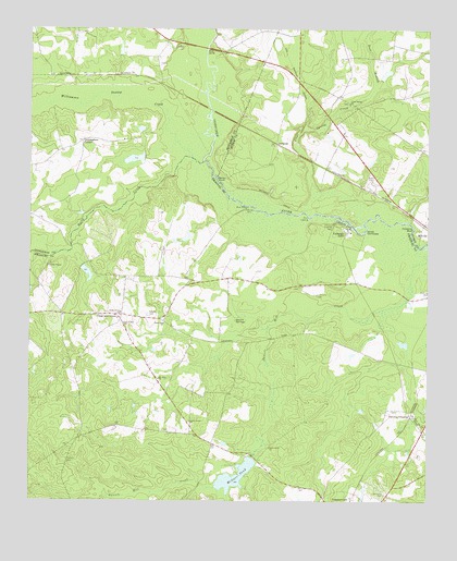
Colemans Lake, GA USGS Topographic Map
Click on map above to begin viewing in our Map Viewer.

This topographic map contains these locations and features:
Feature Name Type Latitude Longitude GNIS ID View Map
Ada Grove ChurchChurchN32.7971°W82.3448°310385View Map
Beegles PondReservoirN32.8106°W82.3569°341390View Map
Beegles Pond DamDamN32.8118°W82.3582°341389View Map
Brown SpringsSpringN32.7979°W82.3093°311880View Map
Bull BranchStreamN32.8607°W82.2657°312013View Map
Clear Spring CreekStreamN32.8279°W82.2871°312726View Map
Clear Spring School (historical)SchoolN32.8552°W82.2746°347960View Map
Colemans CemeteryCemeteryN32.8052°W82.2837°312829View Map
Colemans LakeLakeN32.8237°W82.2759°312832View Map
Colemans LakePopulated PlaceN32.8210°W82.2751°331434View Map
Corinth CemeteryCemeteryN32.7610°W82.3626°312978View Map
Cross and GreenLocaleN32.7993°W82.3473°313154View Map
Cunningham CornerPopulated PlaceN32.8454°W82.3585°326241View Map
Emanuel County Volunteer Fire Department Station 2BuildingN32.7977°W82.3464°2604670View Map
Farmer LakeReservoirN32.8633°W82.2633°340237View Map
Farmer Lake DamDamN32.8618°W82.2632°340236View Map
Forts Grove ChurchChurchN32.7643°W82.2987°314300View Map
Franklins BluffCliffN32.8227°W82.2543°314353View Map
Gambrell LakeReservoirN32.8407°W82.3422°340979View Map
Gambrell Lake DamDamN32.8418°W82.3398°340978View Map
Garbutts CemeteryCemeteryN32.7521°W82.2623°314508View Map
GertrudePopulated PlaceN32.8449°W82.2965°326300View Map
Green Grove ChurchChurchN32.7713°W82.3240°314840View Map
Greens CemeteryCemeteryN32.7999°W82.3371°356103View Map
Lambs ChapelChurchN32.8124°W82.3690°316599View Map
Lambs Chapel CemeteryCemeteryN32.8132°W82.3687°347538View Map
McGars PondReservoirN32.7565°W82.3103°317911View Map
Mcgars Pond DamDamN32.7618°W82.3048°341387View Map
McGars Pond Dam TwoDamN32.7568°W82.3082°337781View Map
McKinzie CemeteryCemeteryN32.7643°W82.3523°347539View Map
Midville International AirportAirportN32.8456°W82.2714°2442665View Map
Mount Sinai ChurchChurchN32.7827°W82.3340°318879View Map
Noah Ark ChurchChurchN32.7971°W82.3323°319606View Map
Number Ten (historical)Populated PlaceN32.8385°W82.2821°348031View Map
Piney Grove ChurchChurchN32.8002°W82.3460°320715View Map
Rayfords BridgeBridgeN32.8699°W82.3193°345756View Map
Rock LandingLocaleN32.8246°W82.2868°332880View Map
Rocky CreekStreamN32.8410°W82.3246°321827View Map
Sandy HookBendN32.8354°W82.3151°322488View Map
Seven CypressesBendN32.8215°W82.2687°322717View Map
Stevens CrossingPopulated PlaceN32.7727°W82.2546°326532View Map
Williamson Swamp CreekStreamN32.8410°W82.3232°325386View Map

Note: Coordinates in the location and feature list above are referenced to NAD83 datum.


Copyright (C) 2008-2025 Ryan Niemi / Sunset Dynamics ... All Rights Reserved