TopoQuest Logo
Do you find TopoQuest useful?
Help keep TopoQuest running and adding new maps/features by donating!
Bitcoin:  19c7KJd3qBynnjoSw5npx9KScwjBe4ifkT
Litecoin:  LXs6TkuXGGXo1vDsWCkWVdjQX94eUKd6ui
Home View Maps Find Maps Find Places Resources & Links


Canoochee, Georgia Topographic Map

USGS Map Title: Canoochee, GA
USGS Map MRC: 32082F2
DRG (GeoTIFF) Download: o32082f2.tif


Neighboring USGS Topographic Map Quads:


  Colemans Lake, GA  
32082G3
 

  Midville, GA  
32082G2
 

  Birdsville, GA  
32082G1
 

  Summertown, GA  
32082F3
 

  Canoochee, GA  
32082F2
 

  Garfield, GA  
32082F1
 

  Swainsboro, GA  
32082E3
 

  Twin City, GA  
32082E2
 

  Twin City SE, GA  
32082E1


Map MRC Location:

N33°
W83°
N33°
W82°
H8 H7 H6 H5 H4 H3 H2 H1
G8 G7 G6 G5 G4 G3 G2 G1
F8 F7 F6 F5 F4 F3 F2 F1
E8 E7 E6 E5 E4 E3 E2 E1
D8 D7 D6 D5 D4 D3 D2 D1
C8 C7 C6 C5 C4 C3 C2 C1
B8 B7 B6 B5 B4 B3 B2 B1
A8 A7 A6 A5 A4 A3 A2 A1
N32°
W83°
N32°
W82°

Canoochee, GA USGS 1:24K Topographic Map Preview:
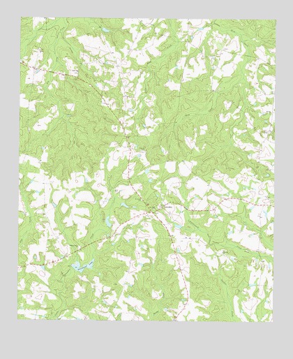
Canoochee, GA USGS Topographic Map
Click on map above to begin viewing in our Map Viewer.

This topographic map contains these locations and features:
Feature Name Type Latitude Longitude GNIS ID View Map
Bishop ChurchChurchN32.7368°W82.2401°354741View Map
Bishops Chapel CemeteryCemeteryN32.7368°W82.2401°347526View Map
CanoocheePopulated PlaceN32.6721°W82.1790°312322View Map
Canoochee Census Designated PlaceCensusN32.6786°W82.1786°2587027View Map
Durden DamDamN32.6635°W82.2065°341385View Map
Durden Farm PondReservoirN32.6658°W82.2060°341386View Map
Emanuel County Volunteer Fire Department Station 5BuildingN32.6722°W82.1799°2604668View Map
Long Creek ChurchChurchN32.7277°W82.2212°317352View Map
Mount Gilead CemeteryCemeteryN32.6749°W82.1890°318637View Map
Mount Gilead ChurchChurchN32.6713°W82.1823°318643View Map
Mount Olivet CemeteryCemeteryN32.7043°W82.1284°347524View Map
Mount Olivet ChurchChurchN32.7038°W82.1282°318787View Map
Mount Zion CemeteryCemeteryN32.7113°W82.1273°347523View Map
Mount Zion ChurchChurchN32.7118°W82.1265°318985View Map
Noonday CemeteryCemeteryN32.6543°W82.1501°347525View Map
Noonday ChurchChurchN32.6538°W82.1493°319617View Map
Overstreet LakeReservoirN32.6464°W82.2210°337780View Map
Overstreet Lake DamDamN32.6468°W82.2229°341383View Map
Overstreet Pond DamDamN32.6468°W82.2132°337779View Map
Roberts Grove ChurchChurchN32.6554°W82.2201°321676View Map
Sand Hill CemeteryCemeteryN32.6957°W82.1871°322422View Map

Note: Coordinates in the location and feature list above are referenced to NAD83 datum.


Copyright (C) 2008-2025 Ryan Niemi / Sunset Dynamics ... All Rights Reserved