TopoQuest Logo
Do you find TopoQuest useful?
Help keep TopoQuest running and adding new maps/features by donating!
Bitcoin:  19c7KJd3qBynnjoSw5npx9KScwjBe4ifkT
Litecoin:  LXs6TkuXGGXo1vDsWCkWVdjQX94eUKd6ui
Home View Maps Find Maps Find Places Resources & Links


Summertown, Georgia Topographic Map

USGS Map Title: Summertown, GA
USGS Map MRC: 32082F3
DRG (GeoTIFF) Download: o32082f3.tif


Neighboring USGS Topographic Map Quads:


  Wadley, GA  
32082G4
 

  Colemans Lake, GA  
32082G3
 

  Midville, GA  
32082G2
 

  Dellwood, GA  
32082F4
 

  Summertown, GA  
32082F3
 

  Canoochee, GA  
32082F2
 

  Norristown, GA  
32082E4
 

  Swainsboro, GA  
32082E3
 

  Twin City, GA  
32082E2


Map MRC Location:

N33°
W83°
N33°
W82°
H8 H7 H6 H5 H4 H3 H2 H1
G8 G7 G6 G5 G4 G3 G2 G1
F8 F7 F6 F5 F4 F3 F2 F1
E8 E7 E6 E5 E4 E3 E2 E1
D8 D7 D6 D5 D4 D3 D2 D1
C8 C7 C6 C5 C4 C3 C2 C1
B8 B7 B6 B5 B4 B3 B2 B1
A8 A7 A6 A5 A4 A3 A2 A1
N32°
W83°
N32°
W82°

Summertown, GA USGS 1:24K Topographic Map Preview:
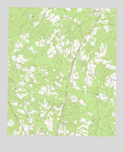
Summertown, GA USGS Topographic Map
Click on map above to begin viewing in our Map Viewer.

This topographic map contains these locations and features:
Feature Name Type Latitude Longitude GNIS ID View Map
Bell LakeReservoirN32.6940°W82.2825°340263View Map
Bell Lake DamDamN32.6935°W82.2832°340262View Map
BlunPopulated PlaceN32.7013°W82.2971°326189View Map
City of SummertownCivilN32.7458°W82.2764°2405543View Map
Dellwood ChurchChurchN32.6699°W82.3623°347533View Map
Emanuel County Volunteer Fire Department Summertown StationBuildingN32.7443°W82.2726°2604039View Map
Georgia State Patrol Troop F Post 19 SwainsboroBuildingN32.6290°W82.3545°2733981View Map
Hawhammock CemeteryCemeteryN32.6407°W82.2737°347531View Map
Hawhammock ChurchChurchN32.6404°W82.2740°356226View Map
Jenkins PondReservoirN32.7416°W82.3497°316073View Map
Jenkins Pond DamDamN32.7440°W82.3496°341405View Map
ModocPopulated PlaceN32.6557°W82.3093°318380View Map
Moxley CemeteryCemeteryN32.6763°W82.3446°347532View Map
New Hope CemeteryCemeteryN32.7321°W82.2915°347530View Map
New Hope ChurchChurchN32.7321°W82.2918°319399View Map
North Prong Canoochee CreekStreamN32.6632°W82.2862°319663View Map
Oak Grove ChurchChurchN32.6366°W82.3096°319795View Map
Old DellwoodPopulated PlaceN32.6685°W82.3657°332564View Map
Second Union ChurchChurchN32.6393°W82.3090°322696View Map
South Prong Canoochee CreekStreamN32.6413°W82.2762°323272View Map
Stanley Grove ChurchChurchN32.6660°W82.2707°323515View Map
SummertownPopulated PlaceN32.7460°W82.2762°323743View Map
Summertown CemeteryCemeteryN32.7413°W82.2715°347527View Map
Summertown DivisionCivilN32.7498°W82.2596°1936562View Map
Summertown Elementary SchoolSchoolN32.7313°W82.2790°347529View Map
Summertown United Methodist ChurchChurchN32.7410°W82.2721°347528View Map
Summertown Volunteer Fire DepartmentBuildingN32.7443°W82.2726°2604362View Map

Note: Coordinates in the location and feature list above are referenced to NAD83 datum.


Copyright (C) 2008-2025 Ryan Niemi / Sunset Dynamics ... All Rights Reserved