TopoQuest Logo
Do you find TopoQuest useful?
Help keep TopoQuest running and adding new maps/features by donating!
Bitcoin:  19c7KJd3qBynnjoSw5npx9KScwjBe4ifkT
Litecoin:  LXs6TkuXGGXo1vDsWCkWVdjQX94eUKd6ui
Home View Maps Find Maps Find Places Resources & Links


Colstrip East, Montana Topographic Map

USGS Map Title: Colstrip East, MT
USGS Map MRC: 45106H5
DRG (GeoTIFF) Download: o45106h5.tif


Neighboring USGS Topographic Map Quads:


  Sheep Creek Camp, MT  
46106A6
 

  McKerlich Creek, MT  
46106A5
 

  Mitchell Coulee, MT  
46106A4
 

  Colstrip West, MT  
45106H6
 

  Colstrip East, MT  
45106H5
 

  Hammond Draw NW, MT  
45106H4
 

  Colstrip SW, MT  
45106G6
 

  Colstrip SE, MT  
45106G5
 

  Hammond Draw SW, MT  
45106G4


Map MRC Location:

N46°
W107°
N46°
W106°
H8 H7 H6 H5 H4 H3 H2 H1
G8 G7 G6 G5 G4 G3 G2 G1
F8 F7 F6 F5 F4 F3 F2 F1
E8 E7 E6 E5 E4 E3 E2 E1
D8 D7 D6 D5 D4 D3 D2 D1
C8 C7 C6 C5 C4 C3 C2 C1
B8 B7 B6 B5 B4 B3 B2 B1
A8 A7 A6 A5 A4 A3 A2 A1
N45°
W107°
N45°
W106°

Colstrip East, MT USGS 1:24K Topographic Map Preview:
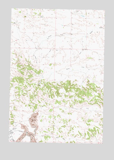
Colstrip East, MT USGS Topographic Map
Click on map above to begin viewing in our Map Viewer.

This topographic map contains these locations and features:
Feature Name Type Latitude Longitude GNIS ID View Map
02N41E01DBBA01 WellWellN45.9553°W106.5747°813552View Map
02N41E02DBBA01 WellWellN45.9556°W106.5964°813553View Map
02N41E08ACCD01 WellWellN45.9539°W106.5953°813549View Map
02N41E12CCAD01 WellWellN45.9361°W106.5825°813449View Map
02N41E24CAAA01 WellWellN45.9114°W106.5784°813312View Map
02N41E24CAAB01 WellWellN45.9117°W106.5795°813318View Map
02N41E34BADC01 WellWellN45.8864°W106.6200°813088View Map
02N41E35CCAD01 WellWellN45.8783°W106.6022°813012View Map
02N41E35DABD01 WellWellN45.8819°W106.5903°813039View Map
02N41E35DABD02 WellWellN45.8819°W106.5903°813040View Map
02N42E04DACA01 WellWellN45.9531°W106.5072°813540View Map
02N42E06CBCD01 WellWellN45.9531°W106.5650°813541View Map
02N42E20CDAD01 WellWellN45.9069°W106.5356°813268View Map
02N42E31CAAA01 WellWellN45.8825°W106.5559°813044View Map
02N42E31DDDD01 WellWellN45.8764°W106.5456°812992View Map
02N42E34DDAD01 WellWellN45.8783°W106.6089°813013View Map
02S41E24CAAA01 WellWellN45.9114°W106.5784°813313View Map
03N41E34BCAB01 WellWellN45.9731°W106.6200°813643View Map
03N41E35CBAA01 WellWellN45.9706°W106.6036°813631View Map
03N42E32C___01 WellWellN45.9658°W106.5395°813611View Map
Big Timber ParkParkN45.8986°W106.6245°1716800View Map
ColstripLocaleN45.8831°W106.6231°1716705View Map
ColstripPopulated PlaceN45.8842°W106.6236°770042View Map
Colstrip CemeteryCemeteryN45.9078°W106.6158°1716827View Map
Court ParkParkN45.8817°W106.6245°1716805View Map
Eagle RockSummitN45.9286°W106.5872°782770View Map
Hopsonville (historical)Populated PlaceN45.9639°W106.6234°1716791View Map
Hopsonville Post Office (historical)Post OfficeN45.9639°W106.6234°1716790View Map
Obert Rye ParkParkN45.8833°W106.6245°1716807View Map
Piedmont ParkParkN45.9000°W106.6236°1716801View Map
Pony Creek School (historical)SchoolN45.9133°W106.5242°1716554View Map
Prospector ParkParkN45.9125°W106.6236°1716798View Map
Rosebud DivisionCivilN45.9428°W106.5141°1940697View Map
South ParkParkN45.8800°W106.6228°1716803View Map
Stillwater ParkParkN45.9094°W106.6236°1716799View Map
Sunnyside School (historical)SchoolN45.9917°W106.6084°1716559View Map

Note: Coordinates in the location and feature list above are referenced to NAD83 datum.


Copyright (C) 2008-2025 Ryan Niemi / Sunset Dynamics ... All Rights Reserved