TopoQuest Logo
Do you find TopoQuest useful?
Help keep TopoQuest running and adding new maps/features by donating!
Bitcoin:  19c7KJd3qBynnjoSw5npx9KScwjBe4ifkT
Litecoin:  LXs6TkuXGGXo1vDsWCkWVdjQX94eUKd6ui
Home View Maps Find Maps Find Places Resources & Links


Congo, Arkansas Topographic Map

USGS Map Title: Congo, AR
USGS Map MRC: 34092F5
DRG (GeoTIFF) Download: o34092f5.tif


Neighboring USGS Topographic Map Quads:


  Fourche SW, AR  
34092G6
 

  Ferndale, AR  
34092G5
 

  Pinnacle Mountain, AR  
34092G4
 

  Lake Norrell, AR  
34092F6
 

  Congo, AR  
34092F5
 

  Alexander, AR  
34092F4
 

  Haskell, AR  
34092E6
 

  Benton, AR  
34092E5
 

  Bryant, AR  
34092E4


Map MRC Location:

N35°
W93°
N35°
W92°
H8 H7 H6 H5 H4 H3 H2 H1
G8 G7 G6 G5 G4 G3 G2 G1
F8 F7 F6 F5 F4 F3 F2 F1
E8 E7 E6 E5 E4 E3 E2 E1
D8 D7 D6 D5 D4 D3 D2 D1
C8 C7 C6 C5 C4 C3 C2 C1
B8 B7 B6 B5 B4 B3 B2 B1
A8 A7 A6 A5 A4 A3 A2 A1
N34°
W93°
N34°
W92°

Congo, AR USGS 1:24K Topographic Map Preview:
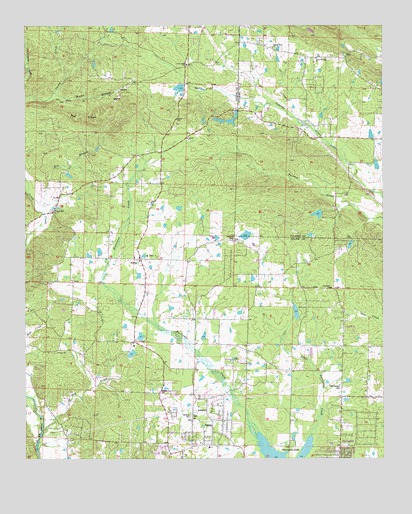
Congo, AR USGS Topographic Map
Click on map above to begin viewing in our Map Viewer.

This topographic map contains these locations and features:
Feature Name Type Latitude Longitude GNIS ID View Map
4-H Camp LakeReservoirN34.6459°W92.5697°81137View Map
4-H Camp Lake DamDamN34.6451°W92.5685°81136View Map
AvillaPopulated PlaceN34.6826°W92.5852°56912View Map
Avilla Census Designated PlaceCensusN34.6989°W92.5813°2612123View Map
Avilla School (historical)SchoolN34.6890°W92.5846°65930View Map
Beauchamp BranchStreamN34.7020°W92.5032°68103View Map
Bethel Middle SchoolSchoolN34.6547°W92.5463°2121475View Map
Big BranchStreamN34.6962°W92.6193°46512View Map
Big RidgeRidgeN34.7237°W92.6057°46589View Map
Cameron CemeteryCemeteryN34.6376°W92.5674°76506View Map
CongoPopulated PlaceN34.6590°W92.5874°57578View Map
Congo Lake DamDamN34.6551°W92.5885°79333View Map
Congo Road Baptist ChurchChurchN34.6559°W92.6138°76659View Map
Congo School (historical)SchoolN34.6568°W92.6141°65956View Map
Cross Road ChurchChurchN34.7390°W92.5690°48201View Map
Crystal LakeReservoirN34.6868°W92.5115°81056View Map
Crystal Lake DamDamN34.6851°W92.5118°81055View Map
Crystal Ridge AirportAirportN34.7276°W92.5165°2650760View Map
Dry CreekStreamN34.6331°W92.6191°48641View Map
Fletcher LakeReservoirN34.6895°W92.5482°79328View Map
Fletcher Lake DamDamN34.6884°W92.5468°79327View Map
Glover LakeReservoirN34.7185°W92.5043°81156View Map
Glover Lake DamDamN34.7168°W92.5035°81155View Map
Gray Hill School (historical)SchoolN34.7487°W92.5891°65992View Map
Hamma BranchStreamN34.7234°W92.5313°68311View Map
Helmich LakeReservoirN34.6605°W92.5850°79332View Map
Helmich Lake DamDamN34.6618°W92.5852°79331View Map
Hester LakeReservoirN34.6674°W92.5307°79330View Map
Hester Lake DamDamN34.6668°W92.5318°79329View Map
Holly SpringsPopulated PlaceN34.7412°W92.5127°68321View Map
Holly Springs ChurchChurchN34.7406°W92.5232°77208View Map
Holly Springs School (historical)SchoolN34.7493°W92.5346°68322View Map
Inman Lake Number TwoReservoirN34.7321°W92.5715°79326View Map
Inman Lake Number Two DamDamN34.7318°W92.5718°79325View Map
Lake Norrell Volunteer Fire Department Station 2BuildingN34.6886°W92.6084°2116689View Map
Lawson ChurchChurchN34.7176°W92.5685°51010View Map
Little Hurricane CreekStreamN34.6318°W92.5254°51283View Map
Maertins LakeReservoirN34.6555°W92.5882°79334View Map
Moore BranchStreamN34.7306°W92.6149°52154View Map
Pilgrim Rest ChurchChurchN34.7437°W92.5388°53379View Map
Pine Crest LakeReservoirN34.6956°W92.5229°81154View Map
Pine Crest Lake DamDamN34.6968°W92.5218°81153View Map
Pipkin CemeteryCemeteryN34.6443°W92.5788°78022View Map
Pleasant Hill Methodist ChurchChurchN34.6965°W92.6157°78046View Map
Pleasant Hill School (historical)SchoolN34.6959°W92.6157°66026View Map
Rose Garden CemeteryCemeteryN34.6454°W92.5152°54196View Map
SalemPopulated PlaceN34.6290°W92.5582°54484View Map
Salem Baptist ChurchChurchN34.6284°W92.5610°66035View Map
Salem Census Designated PlaceCensusN34.6308°W92.5606°2402816View Map
Salem ChurchChurchN34.6537°W92.5529°54498View Map
Salem Fire Department Station 1BuildingN34.6287°W92.5589°2117085View Map
Salem Fire Department Station 2BuildingN34.6584°W92.5854°2117086View Map
SpringhillPopulated PlaceN34.6334°W92.5085°1984807View Map
Springhill ChurchChurchN34.6743°W92.5185°78439View Map
Springhill Elementary SchoolSchoolN34.6529°W92.5169°2039256View Map
Stephens HeliportAirportN34.7365°W92.5088°83753View Map
Tatumville (historical)Populated PlaceN34.7118°W92.5877°66050View Map
Township of BeaverCivilN34.7184°W92.5966°66940View Map
Township of SalemCivilN34.6420°W92.5856°69050View Map
West Pulaski Fire Department Station 1BuildingN34.7451°W92.5419°2117302View Map

Note: Coordinates in the location and feature list above are referenced to NAD83 datum.


Copyright (C) 2008-2024 Ryan Niemi / Sunset Dynamics ... All Rights Reserved