TopoQuest Logo
Do you find TopoQuest useful?
Help keep TopoQuest running and adding new maps/features by donating!
Bitcoin:  19c7KJd3qBynnjoSw5npx9KScwjBe4ifkT
Litecoin:  LXs6TkuXGGXo1vDsWCkWVdjQX94eUKd6ui
Home View Maps Find Maps Find Places Resources & Links


Fourche SW, Arkansas Topographic Map

USGS Map Title: Fourche SW, AR
USGS Map MRC: 34092G6
DRG (GeoTIFF) Download: o34092g6.tif


Neighboring USGS Topographic Map Quads:


  Thornburg, AR  
34092H7
 

  Martindale, AR  
34092H6
 

  Fourche, AR  
34092H5
 

  Paron, AR  
34092G7
 

  Fourche SW, AR  
34092G6
 

  Ferndale, AR  
34092G5
 

  Lonsdale NE, AR  
34092F7
 

  Lake Norrell, AR  
34092F6
 

  Congo, AR  
34092F5


Map MRC Location:

N35°
W93°
N35°
W92°
H8 H7 H6 H5 H4 H3 H2 H1
G8 G7 G6 G5 G4 G3 G2 G1
F8 F7 F6 F5 F4 F3 F2 F1
E8 E7 E6 E5 E4 E3 E2 E1
D8 D7 D6 D5 D4 D3 D2 D1
C8 C7 C6 C5 C4 C3 C2 C1
B8 B7 B6 B5 B4 B3 B2 B1
A8 A7 A6 A5 A4 A3 A2 A1
N34°
W93°
N34°
W92°

Fourche SW, AR USGS 1:24K Topographic Map Preview:
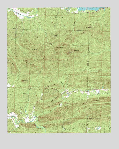
Fourche SW, AR USGS Topographic Map
Click on map above to begin viewing in our Map Viewer.

This topographic map contains these locations and features:
Feature Name Type Latitude Longitude GNIS ID View Map
Allens CreekStreamN34.7670°W92.7160°45836View Map
Bringle CreekStreamN34.8745°W92.6743°46960View Map
Brush MountainRidgeN34.7823°W92.6285°76440View Map
Cave CreekStreamN34.7654°W92.7127°47537View Map
Cock SpursRidgeN34.8193°W92.7241°47878View Map
Cold SpringSpringN34.7935°W92.6918°47903View Map
Cold Spring CemeteryCemeteryN34.7929°W92.6818°47906View Map
Cold Spring MountainSummitN34.7959°W92.6993°57566View Map
Cold Springs (historical)Populated PlaceN34.7940°W92.7002°65954View Map
Cole MountainSummitN34.8018°W92.7307°47917View Map
Crystal MountainSummitN34.8487°W92.6888°48244View Map
Fall MountainSummitN34.8354°W92.6877°48995View Map
Ferguson Ranch (historical)LocaleN34.8251°W92.6271°67483View Map
Flat MountainSummitN34.8006°W92.6993°49111View Map
High PointSummitN34.8337°W92.7182°50102View Map
Horseshoe MountainSummitN34.7840°W92.6927°57947View Map
Jennings MountainSummitN34.7756°W92.7016°57988View Map
Mill CreekStreamN34.7593°W92.7366°52015View Map
Moss MountainSummitN34.8329°W92.6691°52242View Map
Mud Hole BranchStreamN34.7876°W92.6835°52516View Map
Patterson BranchStreamN34.8665°W92.7288°67637View Map
Pigeon Roost MountainSummitN34.8554°W92.6524°53368View Map
Pilot KnobSummitN34.7651°W92.6432°53398View Map
Rattlesnake MountainSummitN34.8301°W92.6766°58464View Map
Red Bluff BranchStreamN34.8654°W92.7168°78141View Map
Round MountainSummitN34.7804°W92.6796°58529View Map
Rush HollowValleyN34.8731°W92.6857°54280View Map
Schoolhouse MountainSummitN34.7604°W92.6782°58593View Map
Smyrna ChurchChurchN34.7906°W92.6763°54968View Map
Vista ParkParkN34.8725°W92.6528°2559922View Map
West Union School (historical)SchoolN34.8734°W92.7307°67721View Map
Wilford PeakSummitN34.8112°W92.6388°67725View Map
Wilhite BranchStreamN34.8715°W92.6613°67726View Map
Wilhite HollowValleyN34.8718°W92.6602°56376View Map

Note: Coordinates in the location and feature list above are referenced to NAD83 datum.


Copyright (C) 2008-2024 Ryan Niemi / Sunset Dynamics ... All Rights Reserved