TopoQuest Logo
Do you find TopoQuest useful?
Help keep TopoQuest running and adding new maps/features by donating!
Bitcoin:  19c7KJd3qBynnjoSw5npx9KScwjBe4ifkT
Litecoin:  LXs6TkuXGGXo1vDsWCkWVdjQX94eUKd6ui
Home View Maps Find Maps Find Places Resources & Links


Conner Lake, Virginia Topographic Map

USGS Map Title: Conner Lake, VA
USGS Map MRC: 36078H7
DRG (GeoTIFF) Download: o36078h7.tif


Neighboring USGS Topographic Map Quads:


  Brookneal, VA  
37078A8
 

  Aspen, VA  
37078A7
 

  Charlotte Court House, VA  
37078A6
 

  Nathalie, VA  
36078H8
 

  Conner Lake, VA  
36078H7
 

  Saxe, VA  
36078H6
 

  Halifax, VA  
36078G8
 

  Scottsburg, VA  
36078G7
 

  Clover, VA  
36078G6


Map MRC Location:

N37°
W79°
N37°
W78°
H8 H7 H6 H5 H4 H3 H2 H1
G8 G7 G6 G5 G4 G3 G2 G1
F8 F7 F6 F5 F4 F3 F2 F1
E8 E7 E6 E5 E4 E3 E2 E1
D8 D7 D6 D5 D4 D3 D2 D1
C8 C7 C6 C5 C4 C3 C2 C1
B8 B7 B6 B5 B4 B3 B2 B1
A8 A7 A6 A5 A4 A3 A2 A1
N36°
W79°
N36°
W78°

Conner Lake, VA USGS 1:24K Topographic Map Preview:
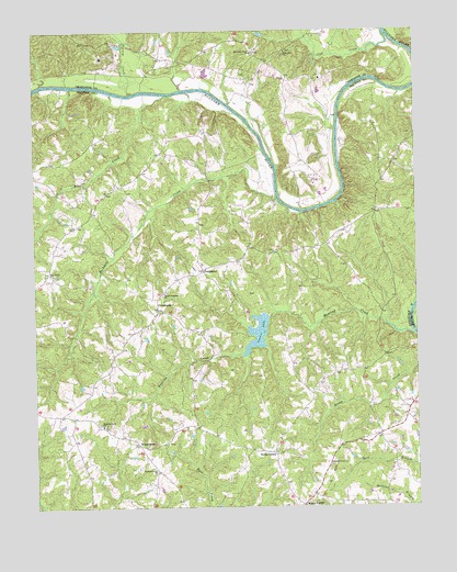
Conner Lake, VA USGS Topographic Map
Click on map above to begin viewing in our Map Viewer.

This topographic map contains these locations and features:
Feature Name Type Latitude Longitude GNIS ID View Map
Bethel Grove ChurchChurchN36.8863°W78.7786°1463211View Map
Buckskin CreekStreamN36.9560°W78.7950°1464022View Map
CarringtonPopulated PlaceN36.8813°W78.8358°1496673View Map
Coles Ferry (historical)CrossingN36.9838°W78.8297°1496680View Map
Conner LakeReservoirN36.9207°W78.8018°1465172View Map
Conners DamDamN36.9249°W78.7978°1489964View Map
CrossroadsPopulated PlaceN36.9268°W78.8345°1477236View Map
Cub CreekStreamN36.9993°W78.7597°1465508View Map
District 2CivilN36.8753°W78.8116°1927202View Map
Ellis CreekStreamN36.9832°W78.8311°1466249View Map
Ellis Creek CemeteryCemeteryN36.9365°W78.8683°1690114View Map
Ellis Creek ChurchChurchN36.9363°W78.8683°1466251View Map
Hunting CreekStreamN36.9201°W78.7506°1468396View Map
Hunting Creek CemeteryCemeteryN36.8962°W78.8520°1690122View Map
Hunting Creek ChurchChurchN36.8965°W78.8528°1468400View Map
Mount LaurelPopulated PlaceN36.8754°W78.7875°1493320View Map
Mount Laurel CemeteryCemeteryN36.8751°W78.7919°1690128View Map
Mount Laurel School (historical)SchoolN36.8918°W78.7747°1496734View Map
Mount Pleasant CemeteryCemeteryN36.9315°W78.8320°1690130View Map
Mount Pleasant ChurchChurchN36.9313°W78.8322°1471034View Map
Neals CornerPopulated PlaceN36.8890°W78.7967°1477571View Map
Old Providence Presbyterian ChurchChurchN36.9388°W78.8197°1496743View Map
Pleasant Grove ChurchChurchN36.8849°W78.8356°1472478View Map
ProvidencePopulated PlaceN36.9374°W78.8195°1477648View Map
Providence CemeteryCemeteryN36.9390°W78.8200°1690143View Map
Ridgeway ChurchChurchN36.9946°W78.7917°1473209View Map
Staunton River ChurchChurchN36.9943°W78.8031°1475099View Map
Triangle Volunteer Fire DepartmentBuildingN36.9015°W78.8635°2075370View Map
Turnip CreekStreamN36.9840°W78.8420°1474290View Map
WatkinsPopulated PlaceN36.9524°W78.7625°1496766View Map
Wests StoreLocaleN36.8915°W78.8408°1476533View Map

Note: Coordinates in the location and feature list above are referenced to NAD83 datum.


Copyright (C) 2008-2025 Ryan Niemi / Sunset Dynamics ... All Rights Reserved