TopoQuest Logo
Do you find TopoQuest useful?
Help keep TopoQuest running and adding new maps/features by donating!
Bitcoin:  19c7KJd3qBynnjoSw5npx9KScwjBe4ifkT
Litecoin:  LXs6TkuXGGXo1vDsWCkWVdjQX94eUKd6ui
Home View Maps Find Maps Find Places Resources & Links


Aspen, Virginia Topographic Map

USGS Map Title: Aspen, VA
USGS Map MRC: 37078A7
DRG (GeoTIFF) Download: o37078a7.tif


Neighboring USGS Topographic Map Quads:


  Mike, VA  
37078B8
 

  Red House, VA  
37078B7
 

  Madisonville, VA  
37078B6
 

  Brookneal, VA  
37078A8
 

  Aspen, VA  
37078A7
 

  Charlotte Court House, VA  
37078A6
 

  Nathalie, VA  
36078H8
 

  Conner Lake, VA  
36078H7
 

  Saxe, VA  
36078H6


Map MRC Location:

N38°
W79°
N38°
W78°
H8 H7 H6 H5 H4 H3 H2 H1
G8 G7 G6 G5 G4 G3 G2 G1
F8 F7 F6 F5 F4 F3 F2 F1
E8 E7 E6 E5 E4 E3 E2 E1
D8 D7 D6 D5 D4 D3 D2 D1
C8 C7 C6 C5 C4 C3 C2 C1
B8 B7 B6 B5 B4 B3 B2 B1
A8 A7 A6 A5 A4 A3 A2 A1
N37°
W79°
N37°
W78°

Aspen, VA USGS 1:24K Topographic Map Preview:
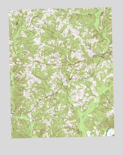
Aspen, VA USGS Topographic Map
Click on map above to begin viewing in our Map Viewer.

This topographic map contains these locations and features:
Feature Name Type Latitude Longitude GNIS ID View Map
Abell (historical)Populated PlaceN37.0715°W78.8508°1690048View Map
AspenPopulated PlaceN37.0410°W78.8267°1477082View Map
Aspen Hill ChurchChurchN37.0249°W78.8222°1462598View Map
AspenwallPopulated PlaceN37.0207°W78.8236°1477083View Map
Baileyville (historical)Populated PlaceN37.0963°W78.8403°1690049View Map
Bethel ChurchChurchN37.0735°W78.7889°1463168View Map
Buck BranchStreamN37.0154°W78.8517°1463975View Map
CamptownLocaleN37.0738°W78.8433°1464384View Map
Cub Creek CemeteryCemeteryN37.0324°W78.7581°1492376View Map
Cub Creek Presbyterian Meeting House (historical)ChurchN37.0324°W78.7581°1738269View Map
Double BranchStreamN37.1063°W78.8620°1465897View Map
Hope ChurchChurchN37.0318°W78.7564°1468224View Map
Little Louse CreekStreamN37.0376°W78.8028°1469584View Map
Louse CreekStreamN37.0204°W78.7878°1469874View Map
Midway ChurchChurchN37.1074°W78.8375°1470435View Map
Midway DistrictCivilN37.1078°W78.8202°1927405View Map
Mount Carmel ChurchChurchN37.0574°W78.8520°1470845View Map
Nazareth ChurchChurchN37.1101°W78.8347°1492410View Map
Old WellLocaleN37.1218°W78.8239°1471883View Map
Roanoke ChurchChurchN37.0171°W78.8206°1473293View Map
Rough CreekStreamN37.0974°W78.7578°1473568View Map
Rough CreekPopulated PlaceN37.1201°W78.7581°1477701View Map
Temple BranchStreamN37.0788°W78.7639°1475534View Map
Turkey BranchStreamN37.1163°W78.7681°1475938View Map
WrenPopulated PlaceN37.1188°W78.8497°1477900View Map

Note: Coordinates in the location and feature list above are referenced to NAD83 datum.


Copyright (C) 2008-2025 Ryan Niemi / Sunset Dynamics ... All Rights Reserved