TopoQuest Logo
Do you find TopoQuest useful?
Help keep TopoQuest running and adding new maps/features by donating!
Bitcoin:  19c7KJd3qBynnjoSw5npx9KScwjBe4ifkT
Litecoin:  LXs6TkuXGGXo1vDsWCkWVdjQX94eUKd6ui
Home View Maps Find Maps Find Places Resources & Links


Conrad East, Iowa Topographic Map

USGS Map Title: Conrad East, IA
USGS Map MRC: 42092B7
DRG (GeoTIFF) Download: o42092b7.tif


Neighboring USGS Topographic Map Quads:


  Ivester, IA  
42092C8
 

  Grundy Center, IA  
42092C7
 

  Lincoln, IA  
42092C6
 

  Conrad West, IA  
42092B8
 

  Conrad East, IA  
42092B7
 

  Gladbrook, IA  
42092B6
 

  Marshalltown, IA  
42092A8
 

  Le Grand, IA  
42092A7
 

  Garwin, IA  
42092A6


Map MRC Location:

N43°
W93°
N43°
W92°
H8 H7 H6 H5 H4 H3 H2 H1
G8 G7 G6 G5 G4 G3 G2 G1
F8 F7 F6 F5 F4 F3 F2 F1
E8 E7 E6 E5 E4 E3 E2 E1
D8 D7 D6 D5 D4 D3 D2 D1
C8 C7 C6 C5 C4 C3 C2 C1
B8 B7 B6 B5 B4 B3 B2 B1
A8 A7 A6 A5 A4 A3 A2 A1
N42°
W93°
N42°
W92°

Conrad East, IA USGS 1:24K Topographic Map Preview:
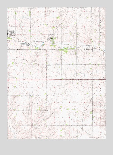
Conrad East, IA USGS Topographic Map
Click on map above to begin viewing in our Map Viewer.

This topographic map contains these locations and features:
Feature Name Type Latitude Longitude GNIS ID View Map
Assembly of God ChurchChurchN42.2261°W92.8680°1983448View Map
BCLUW Elementary SchoolSchoolN42.2287°W92.8695°1983451View Map
BCLUW High SchoolSchoolN42.2257°W92.8667°1983450View Map
BeamanPopulated PlaceN42.2197°W92.8235°454401View Map
Beaman - Conrad Emergency RespondersBuildingN42.2254°W92.8738°2577472View Map
Beaman (historical)LocaleN42.2180°W92.8224°1983456View Map
Beaman Community Memorial LibraryBuildingN42.2200°W92.8238°1983454View Map
Beaman Heritage CenterBuildingN42.2200°W92.8238°1983453View Map
Beaman Memorial HallBuildingN42.2200°W92.8238°1983452View Map
Beaman Post OfficePost OfficeN42.2200°W92.8255°1983457View Map
Beaman Volunteer Fire DepartmentBuildingN42.2197°W92.8252°2577305View Map
Chapel Hill CemeteryCemeteryN42.1261°W92.7671°455344View Map
City of BeamanCivilN42.2202°W92.8222°2394094View Map
City of ConradCivilN42.2234°W92.8740°2393621View Map
Comet TrailTrailN42.2164°W92.8085°1983483View Map
ConradPopulated PlaceN42.2247°W92.8746°455577View Map
Conrad (historical)LocaleN42.2233°W92.8746°1983442View Map
Conrad City HallBuildingN42.2250°W92.8724°1983441View Map
Conrad ClinicHospitalN42.2247°W92.8730°1983446View Map
Conrad Co-operative ElevatorLocaleN42.2222°W92.8746°1983437View Map
Conrad Heritage HallBuildingN42.2250°W92.8724°1983440View Map
Conrad Post OfficePost OfficeN42.2255°W92.8746°1983436View Map
Conrad Public LibraryBuildingN42.2261°W92.8744°1983438View Map
Conrad United Methodist ChurchChurchN42.2272°W92.8724°1983447View Map
Conrad Volunteer Fire DepartmentBuildingN42.2255°W92.8739°1983439View Map
Eyecare Associates CenterHospitalN42.2247°W92.8738°1983444View Map
First Presbyterian ChurchChurchN42.2244°W92.8727°1983449View Map
Greenwood Hill Post Office (historical)Post OfficeN42.2105°W92.8363°1983345View Map
Mid-Iowa Co-op Company ElevatorLocaleN42.2186°W92.8235°1983455View Map
Oakland CemeteryCemeteryN42.2212°W92.8156°459760View Map
Oakview Nursing HomeHospitalN42.2242°W92.8674°1983443View Map
Oakwood Golf CourseLocaleN42.2184°W92.8680°1983435View Map
Plaza Family Dental CenterHospitalN42.2253°W92.8749°1983445View Map
Township of ViennaCivilN42.1667°W92.8259°468869View Map
United Methodist ChurchChurchN42.2214°W92.8219°1983458View Map
ViennaLocaleN42.1669°W92.8252°466194View Map
Vienna CemeteryCemeteryN42.1950°W92.8249°462569View Map
Vienna Post Office (historical)Post OfficeN42.1669°W92.8252°1997051View Map
Vienna Post Office (historical)Post OfficeN42.1825°W92.8252°466652View Map
Wadaloup Post Office (historical)Post OfficeN42.2278°W92.8252°466685View Map

Note: Coordinates in the location and feature list above are referenced to NAD83 datum.


Copyright (C) 2008-2024 Ryan Niemi / Sunset Dynamics ... All Rights Reserved