TopoQuest Logo
Do you find TopoQuest useful?
Help keep TopoQuest running and adding new maps/features by donating!
Bitcoin:  19c7KJd3qBynnjoSw5npx9KScwjBe4ifkT
Litecoin:  LXs6TkuXGGXo1vDsWCkWVdjQX94eUKd6ui
Home View Maps Find Maps Find Places Resources & Links


Le Grand, Iowa Topographic Map

USGS Map Title: Le Grand, IA
USGS Map MRC: 42092A7
DRG (GeoTIFF) Download: o42092a7.tif


Neighboring USGS Topographic Map Quads:


  Conrad West, IA  
42092B8
 

  Conrad East, IA  
42092B7
 

  Gladbrook, IA  
42092B6
 

  Marshalltown, IA  
42092A8
 

  Le Grand, IA  
42092A7
 

  Garwin, IA  
42092A6
 

  Laurel, IA  
41092H8
 

  Gilman, IA  
41092H7
 

  Montour, IA  
41092H6


Map MRC Location:

N43°
W93°
N43°
W92°
H8 H7 H6 H5 H4 H3 H2 H1
G8 G7 G6 G5 G4 G3 G2 G1
F8 F7 F6 F5 F4 F3 F2 F1
E8 E7 E6 E5 E4 E3 E2 E1
D8 D7 D6 D5 D4 D3 D2 D1
C8 C7 C6 C5 C4 C3 C2 C1
B8 B7 B6 B5 B4 B3 B2 B1
A8 A7 A6 A5 A4 A3 A2 A1
N42°
W93°
N42°
W92°

Le Grand, IA USGS 1:24K Topographic Map Preview:
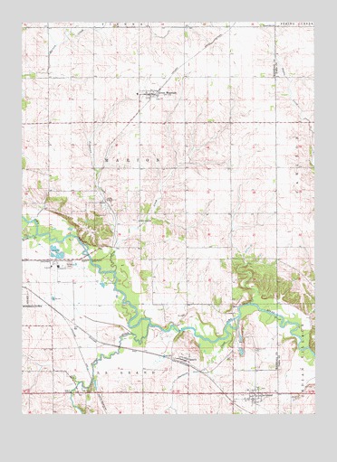
Le Grand, IA USGS Topographic Map
Click on map above to begin viewing in our Map Viewer.

This topographic map contains these locations and features:
Feature Name Type Latitude Longitude GNIS ID View Map
Bowles CemeteryCemeteryN42.0493°W92.8054°1997240View Map
Chapel Hill ChurchChurchN42.1236°W92.7671°455345View Map
City of Le GrandCivilN42.0067°W92.7750°2395654View Map
Davisons CreekStreamN42.0261°W92.7871°455813View Map
East Marshall High SchoolSchoolN42.0077°W92.7790°1997180View Map
Friends ChurchChurchN42.0069°W92.7780°1997179View Map
GMG Elementary SchoolSchoolN42.1068°W92.8242°1997197View Map
Gowanda Post Office (historical)Post OfficeN42.0833°W92.8252°1997034View Map
Green MountainPopulated PlaceN42.1017°W92.8205°457106View Map
Green Mountain (historical)LocaleN42.1022°W92.8183°1997194View Map
Green Mountain CemeteryCemeteryN42.1028°W92.8238°1997244View Map
Green Mountain Census Designated PlaceCensusN42.1019°W92.8196°2629966View Map
Green Mountain First RespondersBuildingN42.1022°W92.8199°2599865View Map
Green Mountain Post OfficePost OfficeN42.1017°W92.8205°1997196View Map
Green Mountain Post Office (historical)Post OfficeN42.0922°W92.8244°466651View Map
Iowa River Brethren CemeteryCemeteryN42.0613°W92.8259°1997242View Map
Iowa River ChurchChurchN42.0617°W92.8249°457836View Map
Le GrandLocaleN42.0003°W92.7766°1997174View Map
Le GrandPopulated PlaceN42.0069°W92.7755°458254View Map
Le Grand BridgeBridgeN42.0272°W92.7835°1997252View Map
Le Grand BridgeBridgeN42.0317°W92.7663°1983337View Map
Le Grand Elevator Company ElevatorLocaleN42.0003°W92.7766°1997173View Map
Le Grand Fire and EMSBuildingN42.0059°W92.7837°1997177View Map
Le Grand Friends CemeteryCemeteryN42.0061°W92.7857°1997239View Map
Le Grand Pioneer Heritage LibraryBuildingN42.0069°W92.7755°1997176View Map
Le Grand Post OfficePost OfficeN42.0064°W92.7763°1997175View Map
Linn CreekStreamN42.0572°W92.8688°458414View Map
Marion Township Fire DepartmentBuildingN42.1022°W92.8199°1997193View Map
Nickolson CreekStreamN42.0547°W92.8344°459520View Map
Pleasant Hill CemeteryCemeteryN42.0208°W92.7763°460248View Map
Predonia (historical)Populated PlaceN42.0550°W92.8044°465548View Map
QuarryLocaleN42.0172°W92.8052°1997037View Map
QuarryPopulated PlaceN42.0172°W92.8052°460481View Map
Quarry BridgeBridgeN42.0264°W92.8083°1997253View Map
Quarry Post Office (historical)Post OfficeN42.0172°W92.8052°1997038View Map
Quinn CemeteryCemeteryN42.0833°W92.8744°1997243View Map
Reedsville Post Office (historical)Post OfficeN42.0639°W92.7919°1997033View Map
Rock CreekStreamN42.0455°W92.8355°460713View Map
Rock Valley CemeteryCemeteryN42.0077°W92.8450°460748View Map
RocktonPopulated PlaceN42.0530°W92.8371°464179View Map
Rockton (historical)LocaleN42.0680°W92.8405°1997036View Map
Rockton Post Office (historical)Post OfficeN42.0680°W92.8405°1997035View Map
Shady Oaks RV CampgroundLocaleN42.0117°W92.8535°1997053View Map
South Rock CreekStreamN42.0792°W92.8091°465547View Map
Terrace Manor Mobile Home CourtPopulated PlaceN42.0064°W92.7844°1997178View Map
Three Bridges County ParkParkN42.0278°W92.8085°1997019View Map
Timber CreekStreamN42.0289°W92.8208°462245View Map
Township of MarionCivilN42.0791°W92.8254°468356View Map
United Church of ChristChurchN42.1036°W92.8199°1997195View Map
Wallin CemeteryCemeteryN42.0528°W92.8141°1997241View Map

Note: Coordinates in the location and feature list above are referenced to NAD83 datum.


Copyright (C) 2008-2024 Ryan Niemi / Sunset Dynamics ... All Rights Reserved