TopoQuest Logo
Do you find TopoQuest useful?
Help keep TopoQuest running and adding new maps/features by donating!
Bitcoin:  19c7KJd3qBynnjoSw5npx9KScwjBe4ifkT
Litecoin:  LXs6TkuXGGXo1vDsWCkWVdjQX94eUKd6ui
Home View Maps Find Maps Find Places Resources & Links


Constantine, Michigan Topographic Map

USGS Map Title: Constantine, MI
USGS Map MRC: 41085G6
DRG (GeoTIFF) Download: o41085g6.tif


Neighboring USGS Topographic Map Quads:


  Jones, MI  
41085H7
 

  Three Rivers West, MI  
41085H6
 

  Three Rivers East, MI  
41085H5
 

  Mottville, MI  
41085G7
 

  Constantine, MI  
41085G6
 

  Klinger Lake, MI  
41085G5
 

  Bristol, IN  
41085F7
 

  Middlebury, IN  
41085F6
 

  Shipshewana, IN  
41085F5


Map MRC Location:

N42°
W86°
N42°
W85°
H8 H7 H6 H5 H4 H3 H2 H1
G8 G7 G6 G5 G4 G3 G2 G1
F8 F7 F6 F5 F4 F3 F2 F1
E8 E7 E6 E5 E4 E3 E2 E1
D8 D7 D6 D5 D4 D3 D2 D1
C8 C7 C6 C5 C4 C3 C2 C1
B8 B7 B6 B5 B4 B3 B2 B1
A8 A7 A6 A5 A4 A3 A2 A1
N41°
W86°
N41°
W85°

Constantine, MI USGS 1:24K Topographic Map Preview:
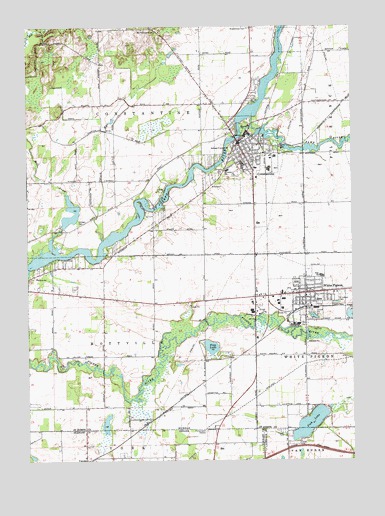
Constantine, MI USGS Topographic Map
Click on map above to begin viewing in our Map Viewer.

This topographic map contains these locations and features:
Feature Name Type Latitude Longitude GNIS ID View Map
Bible Baptist ChurchChurchN41.8375°W85.6686°2418285View Map
Black RunStreamN41.8134°W85.7214°1624397View Map
Brick Chapel CemeteryCemeteryN41.8742°W85.7022°1624414View Map
Broadstreet CemeteryCemeteryN41.8745°W85.6650°1624418View Map
Cedarbrook FarmLocaleN41.8499°W85.6544°2743258View Map
Central Elementary SchoolSchoolN41.7961°W85.6381°2418279View Map
Chenoweth FarmLocaleN41.8331°W85.7016°2743259View Map
Chief Wahbememe Burial Site Historical MarkerParkN41.7978°W85.6631°2401310View Map
Church of ChristChurchN41.7731°W85.6433°2418271View Map
Colonial Estates Mobile Home ParkPopulated PlaceN41.8003°W85.6617°2418273View Map
ConstantinePopulated PlaceN41.8412°W85.6686°1624472View Map
Constantine CemeteryCemeteryN41.8389°W85.6561°2401241View Map
Constantine Fire DepartmentBuildingN41.8415°W85.6700°2418282View Map
Constantine High SchoolSchoolN41.8353°W85.6672°2401031View Map
Constantine Middle SchoolSchoolN41.8356°W85.6681°2401032View Map
Constantine Police DepartmentBuildingN41.8425°W85.6673°2418283View Map
Constantine Post OfficePost OfficeN41.8397°W85.6675°2418280View Map
Constantine Riverview PlaylandParkN41.8439°W85.6669°2418287View Map
Constantine StationLocaleN41.8472°W85.6608°2418290View Map
Constantine Township LibraryBuildingN41.8414°W85.6694°2418281View Map
Constantine Turf FarmLocaleN41.8568°W85.6754°2743260View Map
Constantine United Methodist ChurchChurchN41.8411°W85.6656°2418284View Map
Constantine United Methodist Church Historical MarkerParkN41.8408°W85.6667°2401313View Map
Eastside Elementary SchoolSchoolN41.8342°W85.6619°2401033View Map
Fawn RiverStreamN41.8459°W85.6672°452598View Map
First Congregational ChurchChurchN41.8394°W85.6675°2418286View Map
First Presbyterian ChurchChurchN41.7986°W85.6425°2418268View Map
Fish LakeLakeN41.7606°W85.6417°434510View Map
Hassinger DrainCanalN41.8514°W85.7355°1624595View Map
Heywood House Historical MarkerParkN41.8406°W85.6667°2401315View Map
Light House ChurchChurchN41.7978°W85.6431°2418269View Map
Love Joy DitchCanalN41.7548°W85.7005°438346View Map
Messiah Evangelical Lutheran Church Historical MarkerParkN41.8378°W85.6675°2401314View Map
Messiah Lutheran ChurchChurchN41.8589°W85.6611°2401029View Map
Mill CreekStreamN41.8098°W85.7389°1624739View Map
Pioneer Memorial CemeteryCemeteryN41.8389°W85.6556°2401240View Map
Prairieland FarmsLocaleN41.8228°W85.6634°2743262View Map
Riverside SchoolSchoolN41.8334°W85.6739°1624864View Map
Riverview Mennonite ChurchChurchN41.7917°W85.6633°1624863View Map
Russell FarmsLocaleN41.8364°W85.6448°2743255View Map
Saint Joseph CemeteryCemeteryN41.7975°W85.6300°1624890View Map
Saint Joseph's Catholic ChurchChurchN41.7983°W85.6311°2418272View Map
Stag LakeLakeN41.7827°W85.6796°1624953View Map
Stears FarmsLocaleN41.8506°W85.6474°2743256View Map
Stengle CemeteryCemeteryN41.8184°W85.7297°1624957View Map
Three Rivers State Game AreaParkN41.8694°W85.7444°2417297View Map
Township of ConstantineCivilN41.8524°W85.7029°1626128View Map
Township of MottvilleCivilN41.7827°W85.7188°1626770View Map
Trinity Missionary ChurchChurchN41.8528°W85.6661°2401030View Map
United Methodist ChurchChurchN41.8000°W85.6428°2418270View Map
United States Land Office Historical MarkerParkN41.7981°W85.6436°2401309View Map
Village of ConstantineCivilN41.8379°W85.6650°2398618View Map
Village of White PigeonCivilN41.7979°W85.6485°2400163View Map
Wade ParkParkN41.7989°W85.6406°2401248View Map
Well Field Baseball ParkParkN41.8292°W85.6611°2418291View Map
Whipsering Pines Mobile Home ParkPopulated PlaceN41.8297°W85.6658°2418288View Map
Whipsering Pines Mobile Home ParkPopulated PlaceN41.8297°W85.6658°2418289View Map
White PigeonPopulated PlaceN41.7981°W85.6433°1625017View Map
White Pigeon Junior Senior High SchoolSchoolN41.8031°W85.6369°2418278View Map
White Pigeon Medical CareHospitalN41.7972°W85.6431°2418263View Map
White Pigeon Police DepartmentBuildingN41.7977°W85.6432°2418262View Map
White Pigeon Post OfficePost OfficeN41.7989°W85.6433°2418266View Map
White Pigeon StationLocaleN41.7944°W85.6425°2418267View Map
White Pigeon Township LibraryBuildingN41.7986°W85.6433°2418264View Map

Note: Coordinates in the location and feature list above are referenced to NAD83 datum.


Copyright (C) 2008-2025 Ryan Niemi / Sunset Dynamics ... All Rights Reserved