TopoQuest Logo
Do you find TopoQuest useful?
Help keep TopoQuest running and adding new maps/features by donating!
Bitcoin:  19c7KJd3qBynnjoSw5npx9KScwjBe4ifkT
Litecoin:  LXs6TkuXGGXo1vDsWCkWVdjQX94eUKd6ui
Home View Maps Find Maps Find Places Resources & Links


Bristol, Indiana Topographic Map

USGS Map Title: Bristol, IN
USGS Map MRC: 41085F7
DRG (GeoTIFF) Download: o41085f7.tif


Neighboring USGS Topographic Map Quads:


  Adamsville, MI  
41085G8
 

  Mottville, MI  
41085G7
 

  Constantine, MI  
41085G6
 

  Elkhart, IN  
41085F8
 

  Bristol, IN  
41085F7
 

  Middlebury, IN  
41085F6
 

  Foraker, IN  
41085E8
 

  Goshen, IN  
41085E7
 

  Millersburg, IN  
41085E6


Map MRC Location:

N42°
W86°
N42°
W85°
H8 H7 H6 H5 H4 H3 H2 H1
G8 G7 G6 G5 G4 G3 G2 G1
F8 F7 F6 F5 F4 F3 F2 F1
E8 E7 E6 E5 E4 E3 E2 E1
D8 D7 D6 D5 D4 D3 D2 D1
C8 C7 C6 C5 C4 C3 C2 C1
B8 B7 B6 B5 B4 B3 B2 B1
A8 A7 A6 A5 A4 A3 A2 A1
N41°
W86°
N41°
W85°

Bristol, IN USGS 1:24K Topographic Map Preview:
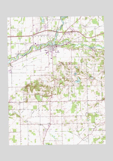
Bristol, IN USGS Topographic Map
Click on map above to begin viewing in our Map Viewer.

This topographic map contains these locations and features:
Feature Name Type Latitude Longitude GNIS ID View Map
Bonneyville CemeteryCemeteryN41.7152°W85.7563°431323View Map
Bonneyville MillsPopulated PlaceN41.7181°W85.7653°431324View Map
BristolPopulated PlaceN41.7214°W85.8175°431536View Map
Bristol Elementary SchoolSchoolN41.7173°W85.8250°446610View Map
Bristol Fire DepartmentBuildingN41.7202°W85.8130°2625725View Map
Bristol Police DeptBuildingN41.7213°W85.8147°2758122View Map
Cathcart CemeteryCemeteryN41.7229°W85.8200°432239View Map
Cornell CemeteryCemeteryN41.6309°W85.7725°432982View Map
Dock LakeLakeN41.6870°W85.7848°433591View Map
Elcona Country ClubLocaleN41.6700°W85.8514°452312View Map
Geising CemeteryCemeteryN41.6531°W85.7536°435005View Map
Goose PondLakeN41.6939°W85.7879°435206View Map
Harmony Acre FarmLocaleN41.6658°W85.7547°2708256View Map
Hatfield AirportAirportN41.6666°W85.8312°449115View Map
Hildreth DitchCanalN41.6787°W85.7925°436182View Map
Hoobirk FarmLocaleN41.6450°W85.7553°2628448View Map
Indian CreekStreamN41.6492°W85.8542°436738View Map
Jefferson Township Fire DepartmentBuildingN41.6451°W85.8206°2626125View Map
Kropf Airport (historical)AirportN41.6425°W85.8336°2676874View Map
Lake GrangePopulated PlaceN41.6903°W85.7692°437531View Map
Leann AcresLocaleN41.6397°W85.7664°2628449View Map
Leann AcresLocaleN41.6400°W85.7667°2708242View Map
Little Elkhart RiverStreamN41.7248°W85.8150°438054View Map
Little Pine ChurchChurchN41.6664°W85.8608°438115View Map
Marlee AcresLocaleN41.6794°W85.7556°2708245View Map
Menges DitchCanalN41.7045°W85.8489°439011View Map
Neff CemeteryCemeteryN41.6559°W85.7728°439980View Map
NibbyvillePopulated PlaceN41.7139°W85.8608°440157View Map
North Fork Pine CreekStreamN41.6362°W85.7814°440256View Map
Oak Ridge CemeteryCemeteryN41.7237°W85.8017°440452View Map
Old Oak FarmLocaleN41.6628°W85.8111°2708004View Map
Pine Creek CemeteryCemeteryN41.6653°W85.8594°441153View Map
Pleasant Ridge ChurchChurchN41.6398°W85.7639°441304View Map
Pleasant View ChurchChurchN41.6450°W85.8356°441348View Map
Proctor CemeteryCemeteryN41.7231°W85.8517°441605View Map
Sheep CreekStreamN41.7053°W85.8733°443333View Map
South Fork Pine CreekStreamN41.6339°W85.7867°443811View Map
Town of BristolCivilN41.7184°W85.8227°2396602View Map
Township of JeffersonCivilN41.6527°W85.8295°453483View Map
Township of WashingtonCivilN41.7274°W85.8312°453994View Map
Trout CreekStreamN41.7492°W85.8058°444920View Map
Washington Township DitchCanalN41.7403°W85.8564°445526View Map
Woodsbrook FarmLocaleN41.6611°W85.7856°2628457View Map
York Elementary SchoolSchoolN41.7217°W85.8203°446611View Map
York Township DitchCanalN41.7498°W85.7508°446403View Map

Note: Coordinates in the location and feature list above are referenced to NAD83 datum.


Copyright (C) 2008-2025 Ryan Niemi / Sunset Dynamics ... All Rights Reserved