TopoQuest Logo
Do you find TopoQuest useful?
Help keep TopoQuest running and adding new maps/features by donating!
Bitcoin:  19c7KJd3qBynnjoSw5npx9KScwjBe4ifkT
Litecoin:  LXs6TkuXGGXo1vDsWCkWVdjQX94eUKd6ui
Home View Maps Find Maps Find Places Resources & Links


Cooks Mills, Illinois Topographic Map

USGS Map Title: Cooks Mills, IL
USGS Map MRC: 39088E4
DRG (GeoTIFF) Download: o39088e4.tif


Neighboring USGS Topographic Map Quads:


  Cadwell, IL  
39088F5
 

  Arthur, IL  
39088F4
 

  Arcola, IL  
39088F3
 

  Sullivan, IL  
39088E5
 

  Cooks Mills, IL  
39088E4
 

  Humboldt, IL  
39088E3
 

  Windsor, IL  
39088D5
 

  Mattoon West, IL  
39088D4
 

  Mattoon East, IL  
39088D3


Map MRC Location:

N40°
W89°
N40°
W88°
H8 H7 H6 H5 H4 H3 H2 H1
G8 G7 G6 G5 G4 G3 G2 G1
F8 F7 F6 F5 F4 F3 F2 F1
E8 E7 E6 E5 E4 E3 E2 E1
D8 D7 D6 D5 D4 D3 D2 D1
C8 C7 C6 C5 C4 C3 C2 C1
B8 B7 B6 B5 B4 B3 B2 B1
A8 A7 A6 A5 A4 A3 A2 A1
N39°
W89°
N39°
W88°

Cooks Mills, IL USGS 1:24K Topographic Map Preview:
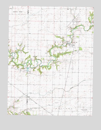
Cooks Mills, IL USGS Topographic Map
Click on map above to begin viewing in our Map Viewer.

This topographic map contains these locations and features:
Feature Name Type Latitude Longitude GNIS ID View Map
Ames School (historical)SchoolN39.5356°W88.3878°403487View Map
Braden School (historical)SchoolN39.5056°W88.4067°404772View Map
Business Knoll School (historical)SchoolN39.6242°W88.4959°1822137View Map
ColesPopulated PlaceN39.5203°W88.4712°406356View Map
Cooks MillsPopulated PlaceN39.5825°W88.4062°406509View Map
Cooks Mills Fire Protection DistrictBuildingN39.5794°W88.4069°2682360View Map
Crabapple School (historical)SchoolN39.5206°W88.4953°406711View Map
Daily RLA Airport (historical)AirportN39.5545°W88.4728°427859View Map
Flat BranchStreamN39.6042°W88.3773°408438View Map
FullerPopulated PlaceN39.5939°W88.4701°422720View Map
Fuller Point School (historical)SchoolN39.5856°W88.4570°408799View Map
Henton School (historical)SchoolN39.5573°W88.4998°410087View Map
Hobert School (historical)SchoolN39.6220°W88.4478°410331View Map
Hoskins School (historical)SchoolN39.5931°W88.3762°410591View Map
Hougland School (historical)SchoolN39.5350°W88.4339°410594View Map
Julian School (historical)SchoolN39.5917°W88.4948°411277View Map
Little Red School (historical)SchoolN39.5931°W88.4248°412399View Map
Mount Zion CemeteryCemeteryN39.5673°W88.4606°1821641View Map
Mount Zion ChurchChurchN39.5673°W88.4614°414136View Map
North Mattoon Oil FieldOilfieldN39.5081°W88.3873°1721051View Map
Pleasant Grove Baptist ChurchChurchN39.5856°W88.4142°1721054View Map
Pleasant Grove CemeteryCemeteryN39.5861°W88.4134°1821642View Map
Quinn ChapelChurchN39.6220°W88.4142°1721055View Map
Senteney School (historical)SchoolN39.6220°W88.4009°418214View Map
Smith CemeteryCemeteryN39.5745°W88.4001°418627View Map
Smith School (historical)SchoolN39.5584°W88.3975°418644View Map
Township of North OkawCivilN39.5864°W88.4152°429462View Map
Wade School (historical)SchoolN39.5456°W88.4528°420360View Map
Zoar CemeteryCemeteryN39.5717°W88.4437°1821643View Map
Zoar ChurchChurchN39.5717°W88.4439°421678View Map

Note: Coordinates in the location and feature list above are referenced to NAD83 datum.


Copyright (C) 2008-2025 Ryan Niemi / Sunset Dynamics ... All Rights Reserved