TopoQuest Logo
Do you find TopoQuest useful?
Help keep TopoQuest running and adding new maps/features by donating!
Bitcoin:  19c7KJd3qBynnjoSw5npx9KScwjBe4ifkT
Litecoin:  LXs6TkuXGGXo1vDsWCkWVdjQX94eUKd6ui
Home View Maps Find Maps Find Places Resources & Links


Cookson, Oklahoma Topographic Map

USGS Map Title: Cookson, OK
USGS Map MRC: 35094F8
DRG (GeoTIFF) Download: o35094f8.tif


Neighboring USGS Topographic Map Quads:


  Zeb, OK  
35095G1
 

  Park Hill, OK  
35094G8
 

  Tailholt, OK  
35094G7
 

  Qualls, OK  
35095F1
 

  Cookson, OK  
35094F8
 

  Bunch, OK  
35094F7
 

  Gore, OK  
35095E1
 

  Blackgum, OK  
35094E8
 

  Marble City, OK  
35094E7


Map MRC Location:

N36°
W95°
N36°
W94°
H8 H7 H6 H5 H4 H3 H2 H1
G8 G7 G6 G5 G4 G3 G2 G1
F8 F7 F6 F5 F4 F3 F2 F1
E8 E7 E6 E5 E4 E3 E2 E1
D8 D7 D6 D5 D4 D3 D2 D1
C8 C7 C6 C5 C4 C3 C2 C1
B8 B7 B6 B5 B4 B3 B2 B1
A8 A7 A6 A5 A4 A3 A2 A1
N35°
W95°
N35°
W94°

Cookson, OK USGS 1:24K Topographic Map Preview:
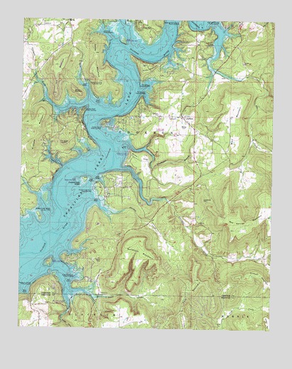
Cookson, OK USGS Topographic Map
Click on map above to begin viewing in our Map Viewer.

This topographic map contains these locations and features:
Feature Name Type Latitude Longitude GNIS ID View Map
Ballew RidgeRidgeN35.6943°W94.9411°1089830View Map
Ballew Ridge Public Use AreaParkN35.6954°W94.9469°1089831View Map
Blackgum Landing Public Use AreaParkN35.6426°W94.9933°1090226View Map
Blackgum Mountain Volunteer Fire Department Station 1 HeadquartersBuildingN35.6331°W94.9945°2657090View Map
Buckhorn MountainSummitN35.6609°W94.9436°1090629View Map
Bullet HillSummitN35.6998°W94.9791°1090688View Map
Canoe MountainSummitN35.7295°W94.9652°1090930View Map
Carlisle Cove Public Use AreaParkN35.7248°W94.9400°1090968View Map
Carlisle Inlet Public Use AreaParkN35.7190°W94.9405°1090969View Map
Cato CreekStreamN35.6329°W94.9752°1091042View Map
Cato Creek Landing Public Use AreaParkN35.6362°W94.9775°1747213View Map
Chicken CreekStreamN35.6723°W94.9563°1091279View Map
Chicken Creek Fire DepartmentBuildingN35.6820°W94.9517°2657093View Map
Chicken Creek IslandIslandN35.6856°W94.9672°1091282View Map
Chicken Creek Point Public Use AreaParkN35.6818°W94.9630°1091283View Map
CooksonPopulated PlaceN35.7109°W94.9200°1100317View Map
Cookson Bend Public Use AreaParkN35.7068°W94.9602°1091623View Map
Cookson BluffCliffN35.7043°W94.9677°1091624View Map
Cookson Bluff Public Use AreaParkN35.7134°W94.9688°1091625View Map
Cookson CemeteryCemeteryN35.7115°W94.9319°1091626View Map
Cookson Volunteer Fire DepartmentBuildingN35.7116°W94.9213°2657003View Map
Elk CreekStreamN35.7348°W94.9047°1092533View Map
Gordon MountainSummitN35.7215°W94.9744°1093267View Map
Griffin MountainSummitN35.7304°W94.9397°1093418View Map
Gum CreekStreamN35.7248°W94.9716°1093438View Map
Joliff Inlet Public Use AreaParkN35.7462°W94.9594°1094254View Map
Keys Fire Department Station 2BuildingN35.7371°W94.9830°2657392View Map
Levi MountainSummitN35.7315°W94.9822°1094590View Map
Limestone HillSummitN35.6776°W94.9094°1094652View Map
Pack MountainSummitN35.6395°W94.9166°1096377View Map
Pine HollowValleyN35.6904°W94.9794°1096659View Map
Sisemore CreekStreamN35.7206°W94.9880°1098067View Map
Sisemore Landing Public Use AreaParkN35.7240°W94.9677°1098068View Map
Sixshooter BranchStreamN35.6965°W94.9369°1098082View Map
Sixshooter Camp Public Use AreaParkN35.6959°W94.9475°1747214View Map
Snake CreekStreamN35.6390°W94.9650°1098150View Map
Snake Creek Cove Public Use AreaParkN35.6476°W94.9725°1098159View Map
Snake Creek Wilderness AirportAirportN35.6507°W94.9487°2717075View Map
Standing Rock Landing Public Use AreaParkN35.7490°W94.9213°1098485View Map
Tenkiller Ferry LakeReservoirN35.6883°W94.9764°1098801View Map
Tenkiller Lake AirparkAirportN35.7079°W94.9323°1102425View Map
Terrapin CreekStreamN35.6756°W94.9361°1098816View Map
Township of CooksonCivilN35.7029°W94.9377°1824592View Map
Turkey BluffCliffN35.6870°W94.9833°1099017View Map
Wildhorse MountainSummitN35.7090°W94.9911°1099798View Map

Note: Coordinates in the location and feature list above are referenced to NAD83 datum.


Copyright (C) 2008-2024 Ryan Niemi / Sunset Dynamics ... All Rights Reserved