TopoQuest Logo
Do you find TopoQuest useful?
Help keep TopoQuest running and adding new maps/features by donating!
Bitcoin:  19c7KJd3qBynnjoSw5npx9KScwjBe4ifkT
Litecoin:  LXs6TkuXGGXo1vDsWCkWVdjQX94eUKd6ui
Home View Maps Find Maps Find Places Resources & Links


Tailholt, Oklahoma Topographic Map

USGS Map Title: Tailholt, OK
USGS Map MRC: 35094G7
DRG (GeoTIFF) Download: o35094g7.tif


Neighboring USGS Topographic Map Quads:


  Tahlequah, OK  
35094H8
 

  Proctor, OK  
35094H7
 

  Christie, OK  
35094H6
 

  Park Hill, OK  
35094G8
 

  Tailholt, OK  
35094G7
 

  Stilwell West, OK  
35094G6
 

  Cookson, OK  
35094F8
 

  Bunch, OK  
35094F7
 

  Greasy, OK  
35094F6


Map MRC Location:

N36°
W95°
N36°
W94°
H8 H7 H6 H5 H4 H3 H2 H1
G8 G7 G6 G5 G4 G3 G2 G1
F8 F7 F6 F5 F4 F3 F2 F1
E8 E7 E6 E5 E4 E3 E2 E1
D8 D7 D6 D5 D4 D3 D2 D1
C8 C7 C6 C5 C4 C3 C2 C1
B8 B7 B6 B5 B4 B3 B2 B1
A8 A7 A6 A5 A4 A3 A2 A1
N35°
W95°
N35°
W94°

Tailholt, OK USGS 1:24K Topographic Map Preview:
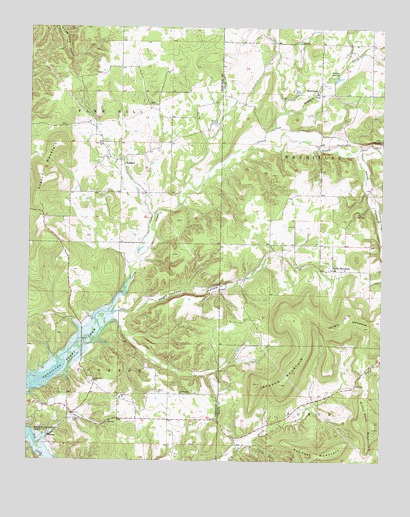
Tailholt, OK USGS Topographic Map
Click on map above to begin viewing in our Map Viewer.

This topographic map contains these locations and features:
Feature Name Type Latitude Longitude GNIS ID View Map
Assembly ChurchChurchN35.8412°W94.8494°1089738View Map
BarberPopulated PlaceN35.7573°W94.8677°1100193View Map
Barber CemeteryCemeteryN35.7620°W94.8597°1089853View Map
Barber ChurchChurchN35.7698°W94.8286°1089854View Map
Bidding CreekStreamN35.8429°W94.7916°1090078View Map
Bitting SpringSpringN35.8620°W94.7658°1090183View Map
Caney CemeteryCemeteryN35.8470°W94.8083°1090909View Map
East Cherokee DivisionCivilN35.8432°W94.8664°1937691View Map
Highway 100 West Volunteer Fire DepartmentBuildingN35.8066°W94.7675°2657287View Map
Hungry MountainSummitN35.7887°W94.7688°1094018View Map
Independent ChurchChurchN35.7695°W94.8211°1094068View Map
Indian Home ChurchChurchN35.7729°W94.8522°1094093View Map
Jackson MountainSummitN35.7776°W94.7808°1094161View Map
July SpringSpringN35.8426°W94.7513°1094272View Map
Negro Jake HollowValleyN35.7923°W94.8402°1095778View Map
North Fork Dry CreekStreamN35.7559°W94.7958°1095950View Map
Rocky MountainCivilN35.7936°W94.7780°2631162View Map
Rocky MountainPopulated PlaceN35.8054°W94.7674°1100797View Map
Rocky Mountain Census Designated PlaceCensusN35.7936°W94.7780°2409199View Map
Rocky Mountain SchoolSchoolN35.8055°W94.7668°1790733View Map
Sanders MountainSummitN35.7518°W94.7755°1097789View Map
Smith HollowValleyN35.8390°W94.7597°1098136View Map
South Fork Dry CreekStreamN35.7559°W94.7958°1098237View Map
Stony Point CemeteryCemeteryN35.8422°W94.7625°1098565View Map
Sugar MountainSummitN35.8415°W94.8658°1098604View Map
TailholtPopulated PlaceN35.8368°W94.8422°1098726View Map
TenkillerPopulated PlaceN35.8006°W94.8638°1853486View Map
TenkillerCivilN35.7978°W94.8659°2631185View Map
Tenkiller Census Designated PlaceCensusN35.7975°W94.8655°2410066View Map
Tenkiller Elementary SchoolSchoolN35.7680°W94.8420°1098802View Map
Township of WauhillauCivilN35.8501°W94.7505°1102856View Map
WauhillauPopulated PlaceN35.8570°W94.7733°1100925View Map
WauhillauCivilN35.8654°W94.7637°2631197View Map
Wauhillau Census Designated PlaceCensusN35.8682°W94.7623°2584395View Map
WellingCivilN35.8556°W94.8454°2631198View Map
Welling Census Designated PlaceCensusN35.8561°W94.8457°2409541View Map
Welling Tri - Community Fire Department Station 3BuildingN35.8362°W94.8424°2657390View Map

Note: Coordinates in the location and feature list above are referenced to NAD83 datum.


Copyright (C) 2008-2024 Ryan Niemi / Sunset Dynamics ... All Rights Reserved