TopoQuest Logo
Do you find TopoQuest useful?
Help keep TopoQuest running and adding new maps/features by donating!
Bitcoin:  19c7KJd3qBynnjoSw5npx9KScwjBe4ifkT
Litecoin:  LXs6TkuXGGXo1vDsWCkWVdjQX94eUKd6ui
Home View Maps Find Maps Find Places Resources & Links


Coolin, Idaho Topographic Map

USGS Map Title: Coolin, ID
USGS Map MRC: 48116D7
DRG (GeoTIFF) Download: o48116d7.tif


Neighboring USGS Topographic Map Quads:


  Priest Lake SW, ID  
48116E8
 

  Priest Lake SE, ID  
48116E7
 

  Mount Roothaan, ID  
48116E6
 

  Outlet Bay, ID  
48116D8
 

  Coolin, ID  
48116D7
 

  Mount Casey, ID  
48116D6
 

  Quartz Mountain, ID  
48116C8
 

  Prater Mountain, ID  
48116C7
 

  Happy Fork Gap, ID  
48116C6


Map MRC Location:

N49°
W117°
N49°
W116°
H8 H7 H6 H5 H4 H3 H2 H1
G8 G7 G6 G5 G4 G3 G2 G1
F8 F7 F6 F5 F4 F3 F2 F1
E8 E7 E6 E5 E4 E3 E2 E1
D8 D7 D6 D5 D4 D3 D2 D1
C8 C7 C6 C5 C4 C3 C2 C1
B8 B7 B6 B5 B4 B3 B2 B1
A8 A7 A6 A5 A4 A3 A2 A1
N48°
W117°
N48°
W116°

Coolin, ID USGS 1:24K Topographic Map Preview:
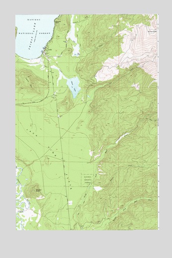
Coolin, ID USGS Topographic Map
Click on map above to begin viewing in our Map Viewer.

This topographic map contains these locations and features:
Feature Name Type Latitude Longitude GNIS ID View Map
Chase CreekStreamN48.4758°W116.8538°379204View Map
Chase LakeLakeN48.4596°W116.8246°379205View Map
Chase Lake Access AreaLocaleN48.4549°W116.8324°401240View Map
CoolinPopulated PlaceN48.4796°W116.8494°396325View Map
Coolin Cavanaugh Bay Fire DistrictBuildingN48.4763°W116.8428°2619068View Map
Coolin MountainSummitN48.4605°W116.8608°379655View Map
Coolin Post OfficePost OfficeN48.4803°W116.8485°2766808View Map
Jack Pine FlatsFlatN48.4224°W116.8483°383811View Map
Junta CreekStreamN48.4416°W116.7574°384081View Map
Lee CreekStreamN48.4952°W116.8252°384515View Map
Lee LakeLakeN48.4766°W116.8221°384518View Map
Lost CreekStreamN48.4008°W116.8110°386141View Map
Plumbago PointCapeN48.4969°W116.8391°394884View Map
Sherwood BeachPopulated PlaceN48.4966°W116.8405°397157View Map
Sundance Lookout StationLocaleN48.4908°W116.7516°395026View Map
Sundance MountainSummitN48.4908°W116.7516°391648View Map
Waters CreekStreamN48.3996°W116.8116°392946View Map
Whitetail ButteSummitN48.3980°W116.8580°393390View Map

Note: Coordinates in the location and feature list above are referenced to NAD83 datum.


Copyright (C) 2008-2024 Ryan Niemi / Sunset Dynamics ... All Rights Reserved