TopoQuest Logo
Do you find TopoQuest useful?
Help keep TopoQuest running and adding new maps/features by donating!
Bitcoin:  19c7KJd3qBynnjoSw5npx9KScwjBe4ifkT
Litecoin:  LXs6TkuXGGXo1vDsWCkWVdjQX94eUKd6ui
Home View Maps Find Maps Find Places Resources & Links


Cornstalk, West Virginia Topographic Map

USGS Map Title: Cornstalk, WV
USGS Map MRC: 37080H5
DRG (GeoTIFF) Download: o37080h5.tif


Neighboring USGS Topographic Map Quads:


  Quinwood, WV  
38080A6
 

  Duo, WV  
38080A5
 

  Trout, WV  
38080A4
 

  Rupert, WV  
37080H6
 

  Cornstalk, WV  
37080H5
 

  Williamsburg, WV  
37080H4
 

  Dawson, WV  
37080G6
 

  Asbury, WV  
37080G5
 

  Lewisburg, WV  
37080G4


Map MRC Location:

N38°
W81°
N38°
W80°
H8 H7 H6 H5 H4 H3 H2 H1
G8 G7 G6 G5 G4 G3 G2 G1
F8 F7 F6 F5 F4 F3 F2 F1
E8 E7 E6 E5 E4 E3 E2 E1
D8 D7 D6 D5 D4 D3 D2 D1
C8 C7 C6 C5 C4 C3 C2 C1
B8 B7 B6 B5 B4 B3 B2 B1
A8 A7 A6 A5 A4 A3 A2 A1
N37°
W81°
N37°
W80°

Cornstalk, WV USGS 1:24K Topographic Map Preview:
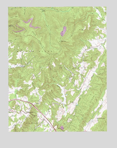
Cornstalk, WV USGS Topographic Map
Click on map above to begin viewing in our Map Viewer.

This topographic map contains these locations and features:
Feature Name Type Latitude Longitude GNIS ID View Map
At the End of the Trail CemeteryCemeteryN37.8960°W80.6237°1535067View Map
Beaver Creek Baptist ChurchChurchN37.9404°W80.6068°1535450View Map
Beech RunStreamN37.9996°W80.6045°1535549View Map
Brushy Flat School (historical)SchoolN37.8865°W80.5798°1556252View Map
Brushy RidgeRidgeN37.8998°W80.5226°1536521View Map
Buffalo MountainSummitN37.9732°W80.5567°1536646View Map
ClintonvillePopulated PlaceN37.8940°W80.5990°1554155View Map
Clintonville Post OfficePost OfficeN37.8937°W80.6020°1559384View Map
Clintonville Volunteer Fire DepartmentBuildingN37.8885°W80.5853°2577938View Map
Cold Spring ChurchChurchN37.9435°W80.5326°1537503View Map
CornstalkPopulated PlaceN37.9462°W80.5295°1549642View Map
Cornstalk Post OfficePost OfficeN37.9465°W80.5301°1559385View Map
Cross MountainSummitN37.9726°W80.5909°1537872View Map
Enox SpringSpringN37.9454°W80.5290°1557507View Map
Flynn CreekStreamN37.9873°W80.5042°1551148View Map
Hickory RidgeRidgeN37.9898°W80.6173°1540219View Map
Hopewell School (historical)SchoolN37.9287°W80.5281°1556304View Map
Huggins KnobSummitN37.9660°W80.5579°1540562View Map
HughartPopulated PlaceN37.9021°W80.5512°1554755View Map
Hughart CreekStreamN37.8807°W80.5590°1540564View Map
James Chapel United Methodist ChurchChurchN37.8954°W80.5740°1540811View Map
Johnson Truck SpringSpringN37.8807°W80.5442°1557540View Map
Judy RidgeRidgeN37.9498°W80.5181°1541036View Map
KiefferPopulated PlaceN37.9401°W80.6095°1541186View Map
Kieffer Post OfficePost OfficeN37.9404°W80.6073°1559392View Map
Kuhn BranchStreamN37.9979°W80.5695°1551673View Map
LaFayette BottomBasinN37.9960°W80.5804°1541299View Map
Laurel CreekStreamN37.9971°W80.5809°1541402View Map
Liberty School (historical)SchoolN37.9271°W80.5534°1556312View Map
Long PointCapeN37.9748°W80.6187°1542391View Map
Meadow MountainSummitN37.9029°W80.5859°1555095View Map
Meadow Mountain School (historical)SchoolN37.9118°W80.5870°1556323View Map
Mount Prospect School (historical)SchoolN37.9307°W80.5906°1556330View Map
Mrs Cochran SpringSpringN37.9085°W80.5831°1557571View Map
New Bethel ChurchChurchN37.9285°W80.5476°1544108View Map
New Salem ChurchChurchN37.9940°W80.5015°1544139View Map
Oak Grove School (historical)SchoolN37.9157°W80.6140°1556338View Map
Pembroke School (historical)SchoolN37.9937°W80.5012°1556342View Map
Pleasant Valley School (historical)SchoolN37.9571°W80.5229°1556350View Map
Roach RunStreamN37.9212°W80.5612°1545789View Map
Rock CliffPopulated PlaceN37.9637°W80.6240°1555499View Map
Rock Cliff School (historical)SchoolN37.9668°W80.6245°1556357View Map
Rose KnobSummitN37.9771°W80.5323°1555522View Map
Russell Haynes SpringSpringN37.9426°W80.5734°1557595View Map
Sinking Creek Baptist ChurchChurchN37.9040°W80.5431°1546833View Map
Spotts Ridge School (historical)SchoolN37.8826°W80.6098°1556371View Map
Stong RunStreamN37.9612°W80.5059°1547490View Map
Sunrise ChapelChurchN37.8946°W80.5992°1547757View Map
Tater RunStreamN37.9143°W80.5359°1547916View Map
Wallace BranchStreamN37.9987°W80.5734°1553360View Map
Wallace Memorial CemeteryCemeteryN37.8973°W80.6229°1548740View Map
Western DistrictCivilN37.9874°W80.6237°1928408View Map
Westview School (historical)SchoolN37.9518°W80.6220°1556384View Map
Williamsburg Rescue Squad IncorporatedBuildingN37.9672°W80.5007°2581057View Map
Williamsburg Volunteer Fire DepartmentBuildingN37.9673°W80.5009°2577832View Map

Note: Coordinates in the location and feature list above are referenced to NAD83 datum.


Copyright (C) 2008-2025 Ryan Niemi / Sunset Dynamics ... All Rights Reserved