TopoQuest Logo
Do you find TopoQuest useful?
Help keep TopoQuest running and adding new maps/features by donating!
Bitcoin:  19c7KJd3qBynnjoSw5npx9KScwjBe4ifkT
Litecoin:  LXs6TkuXGGXo1vDsWCkWVdjQX94eUKd6ui
Home View Maps Find Maps Find Places Resources & Links


Costello Island, Texas Topographic Map

USGS Map Title: Costello Island, TX
USGS Map MRC: 32098H4
DRG (GeoTIFF) Download: o32098h4.tif


Neighboring USGS Topographic Map Quads:


  Graham, TX  
33098A5
 

  Ross Mountain, TX  
33098A4
 

  Long Hollow, TX  
33098A3
 

  Cove Creek, TX  
32098H5
 

  Costello Island, TX  
32098H4
 

  Graford West, TX  
32098H3
 

  Brad, TX  
32098G5
 

  Fortune Bend, TX  
32098G4
 

  Palo Pinto, TX  
32098G3


Map MRC Location:

N33°
W99°
N33°
W98°
H8 H7 H6 H5 H4 H3 H2 H1
G8 G7 G6 G5 G4 G3 G2 G1
F8 F7 F6 F5 F4 F3 F2 F1
E8 E7 E6 E5 E4 E3 E2 E1
D8 D7 D6 D5 D4 D3 D2 D1
C8 C7 C6 C5 C4 C3 C2 C1
B8 B7 B6 B5 B4 B3 B2 B1
A8 A7 A6 A5 A4 A3 A2 A1
N32°
W99°
N32°
W98°

Costello Island, TX USGS 1:24K Topographic Map Preview:
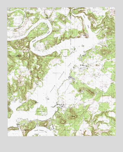
Costello Island, TX USGS Topographic Map
Click on map above to begin viewing in our Map Viewer.

This topographic map contains these locations and features:
Feature Name Type Latitude Longitude GNIS ID View Map
Ainsworth CreekStreamN32.9098°W98.4953°1329283View Map
Bald MountainSummitN32.9087°W98.4687°1329975View Map
Bloodweed IslandIslandN32.9235°W98.4470°1330879View Map
Brushy SloughStreamN32.9296°W98.4614°1331457View Map
Carter BendBendN32.9601°W98.4187°1332212View Map
Carter IslandIslandN32.9648°W98.4128°1332219View Map
Chimney SloughBayN32.9229°W98.4651°1332763View Map
Connor CreekStreamN32.9971°W98.4812°1373184View Map
Costello IslandIslandN32.9007°W98.4603°1333403View Map
Costello Island, Inc AirportAirportN32.8961°W98.4613°1386746View Map
Crow PeakSummitN32.9893°W98.4376°1333740View Map
Deep Elm CreekStreamN32.9465°W98.4201°1334196View Map
Devils HollowValleyN32.9592°W98.4734°1334301View Map
Elm CreekStreamN32.9121°W98.4870°1335361View Map
Filibuster CreekStreamN32.9890°W98.4545°1335790View Map
Frog BranchStreamN32.9740°W98.3989°1336267View Map
Gordon MountainSummitN32.9743°W98.4128°1336735View Map
Harris PeakSummitN32.9376°W98.4742°1337397View Map
Johnson PeakSummitN32.8807°W98.4787°1338808View Map
Lukingdom ChurchChurchN32.9160°W98.3981°1340734View Map
McAdams CemeteryCemeteryN32.9032°W98.4373°1341130View Map
McAdams PeakSummitN32.8940°W98.4237°1341131View Map
McAvoy MountainSummitN32.9187°W98.4167°1341136View Map
McGinnis PointCapeN32.9040°W98.4459°1341207View Map
Ming BendBendN32.9910°W98.4878°1341716View Map
Palo Pinto County Sheriff's Office Possum Kingdom Lake SubstationBuildingN32.8900°W98.4496°2750744View Map
Possum Kingdom AirportAirportN32.9232°W98.4384°1386744View Map
Possum Kingdom Lake Volunteer Emergency Medical ServicesBuildingN32.9169°W98.4338°2656149View Map
Ramsey CreekStreamN32.9657°W98.3956°1375620View Map
Rock CreekStreamN32.9696°W98.4026°1375780View Map
Sand IslandIslandN32.9112°W98.4559°1346525View Map
Storms MountainSummitN32.9168°W98.4026°1347978View Map
Waco BendBendN32.9621°W98.4667°1349335View Map
Wild BendBendN32.9835°W98.4576°1350052View Map

Note: Coordinates in the location and feature list above are referenced to NAD83 datum.


Copyright (C) 2008-2025 Ryan Niemi / Sunset Dynamics ... All Rights Reserved