TopoQuest Logo
Do you find TopoQuest useful?
Help keep TopoQuest running and adding new maps/features by donating!
Bitcoin:  19c7KJd3qBynnjoSw5npx9KScwjBe4ifkT
Litecoin:  LXs6TkuXGGXo1vDsWCkWVdjQX94eUKd6ui
Home View Maps Find Maps Find Places Resources & Links


Cottage Grove Lake, Oregon Topographic Map

USGS Map Title: Cottage Grove Lake, OR
USGS Map MRC: 43123F1
DRG (GeoTIFF) Download: o43123f1.tif


Neighboring USGS Topographic Map Quads:


  Lorane, OR  
43123G2
 

  Cottage Grove, OR  
43123G1
 

  Dorena Lake, OR  
43122G8
 

  Curtin, OR  
43123F2
 

  Cottage Grove Lake, OR  
43123F1
 

  Blue Mountain, OR  
43122F8
 

  Scotts Valley, OR  
43123E2
 

  Harness Mountain, OR  
43123E1
 

  Burnt Mountain, OR  
43122E8


Map MRC Location:

N44°
W124°
N44°
W123°
H8 H7 H6 H5 H4 H3 H2 H1
G8 G7 G6 G5 G4 G3 G2 G1
F8 F7 F6 F5 F4 F3 F2 F1
E8 E7 E6 E5 E4 E3 E2 E1
D8 D7 D6 D5 D4 D3 D2 D1
C8 C7 C6 C5 C4 C3 C2 C1
B8 B7 B6 B5 B4 B3 B2 B1
A8 A7 A6 A5 A4 A3 A2 A1
N43°
W124°
N43°
W123°

Cottage Grove Lake, OR USGS 1:24K Topographic Map Preview:
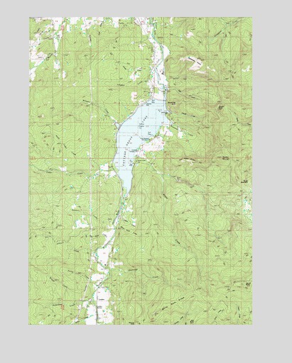
Cottage Grove Lake, OR USGS Topographic Map
Click on map above to begin viewing in our Map Viewer.

This topographic map contains these locations and features:
Feature Name Type Latitude Longitude GNIS ID View Map
Alex Small CreekStreamN43.6596°W123.0784°1116845View Map
Anderson CreekStreamN43.6335°W123.0881°1116927View Map
Army BridgeBridgeN43.6768°W123.0734°1638799View Map
Beaver CreekStreamN43.6335°W123.0976°1117420View Map
Beck CreekStreamN43.6873°W123.1026°1133033View Map
Brush MountainSummitN43.6831°W123.0025°1118157View Map
Cedar CreekStreamN43.6885°W123.0765°1118725View Map
Champion CreekStreamN43.7496°W123.0048°1118810View Map
Chapman ButteSummitN43.6993°W123.1176°1133045View Map
Cottage Grove DamDamN43.7148°W123.0545°1131292View Map
Cottage Grove LakeReservoirN43.7025°W123.0649°1158179View Map
Elkhorn CreekStreamN43.7332°W123.0526°1133040View Map
Ewing CreekStreamN43.6418°W123.0854°1120546View Map
GapPopulated PlaceN43.7357°W123.0559°1121055View Map
H Taylor CreekStreamN43.6640°W123.0759°1121502View Map
Harris CreekStreamN43.6682°W123.0756°1121621View Map
Harvey CreekStreamN43.7068°W123.0776°1133037View Map
Hebron ChurchChurchN43.6990°W123.0787°1121727View Map
Hobart CreekStreamN43.6301°W123.0876°1121856View Map
Hoodoo MountainSummitN43.6927°W123.0187°1136389View Map
Johnson CreekStreamN43.6548°W123.0879°1122477View Map
Kellys ButteSummitN43.7094°W123.1189°1133046View Map
Lakeside ParkParkN43.7151°W123.0609°1157651View Map
Lakeside Park Boat RampLocaleN43.7167°W123.0570°2668266View Map
Langdon CreekStreamN43.7273°W123.0551°1122948View Map
Laurel ButteSummitN43.6412°W123.0051°1136464View Map
LondonPopulated PlaceN43.6346°W123.0929°1157799View Map
London Post Office (historical)Post OfficeN43.6346°W123.0912°1165558View Map
London SchoolSchoolN43.6491°W123.0831°1123363View Map
London SpringsPopulated PlaceN43.6318°W123.0912°1123364View Map
Lone Pine CemeteryCemeteryN43.6532°W123.0808°1133028View Map
Massey CreekStreamN43.6429°W123.0817°1133026View Map
McWilliams CreekStreamN43.7221°W123.0929°1133039View Map
Murray CreekStreamN43.7012°W123.0762°1133036View Map
North Cedar CreekStreamN43.6885°W123.0756°1124731View Map
Numbers CreekStreamN43.6662°W123.0784°1124865View Map
Pine Meadows CampgroundLocaleN43.7004°W123.0592°1157650View Map
Piper CreekStreamN43.7204°W123.0495°1125443View Map
Powell CreekStreamN43.7110°W123.0470°1125632View Map
Primitive CampgroundLocaleN43.6957°W123.0651°1157652View Map
Rattlesnake PrairieFlatN43.7335°W123.0370°1125837View Map
Rodgers CreekStreamN43.7012°W123.0567°1133034View Map
Sheldon CreekStreamN43.7373°W123.0512°1133041View Map
Shortridge ButteSummitN43.7147°W123.0440°1136751View Map
Shortridge CreekStreamN43.6465°W123.0798°1126921View Map
Shortridge ParkParkN43.7110°W123.0484°1157649View Map
Snyder CreekStreamN43.7268°W123.0562°1127175View Map
Sweeney CreekStreamN43.7068°W123.0467°1127826View Map
Taylor - Lane CemeteryCemeteryN43.7490°W123.0669°1133043View Map
Thorne BridgeBridgeN43.6479°W123.0817°1128052View Map
Twin Prairie ButtesSummitN43.6909°W123.0328°1136852View Map
Wallace (historical)Populated PlaceN43.6526°W123.0887°1133027View Map
Wallace CreekStreamN43.7473°W123.0556°1157647View Map
Wallace Post Office (historical)Post OfficeN43.6526°W123.0887°1166118View Map
White Rock RidgeRidgeN43.6343°W123.0462°1128997View Map
Whites CreekStreamN43.7415°W123.0581°1133042View Map
Whitney CreekStreamN43.7221°W123.0512°1133038View Map
Williams CreekStreamN43.7068°W123.0770°1129112View Map
Williams LakeReservoirN43.7126°W123.1081°1157648View Map
Wilson CreekStreamN43.6935°W123.0670°1129190View Map
Wilson Creek Boat RampLocaleN43.6901°W123.0681°2668474View Map
Wilson Creek ParkParkN43.6915°W123.0665°1157798View Map
Youngs ButteSummitN43.7124°W123.0205°1136934View Map
Youngs CreekStreamN43.7068°W123.0456°1133035View Map

Note: Coordinates in the location and feature list above are referenced to NAD83 datum.


Copyright (C) 2008-2024 Ryan Niemi / Sunset Dynamics ... All Rights Reserved