TopoQuest Logo
Do you find TopoQuest useful?
Help keep TopoQuest running and adding new maps/features by donating!
Bitcoin:  19c7KJd3qBynnjoSw5npx9KScwjBe4ifkT
Litecoin:  LXs6TkuXGGXo1vDsWCkWVdjQX94eUKd6ui
Home View Maps Find Maps Find Places Resources & Links


Curtin, Oregon Topographic Map

USGS Map Title: Curtin, OR
USGS Map MRC: 43123F2
DRG (GeoTIFF) Download: o43123f2.tif


Neighboring USGS Topographic Map Quads:


  Letz Creek, OR  
43123G3
 

  Lorane, OR  
43123G2
 

  Cottage Grove, OR  
43123G1
 

  Drain, OR  
43123F3
 

  Curtin, OR  
43123F2
 

  Cottage Grove Lake, OR  
43123F1
 

  Yoncalla, OR  
43123E3
 

  Scotts Valley, OR  
43123E2
 

  Harness Mountain, OR  
43123E1


Map MRC Location:

N44°
W124°
N44°
W123°
H8 H7 H6 H5 H4 H3 H2 H1
G8 G7 G6 G5 G4 G3 G2 G1
F8 F7 F6 F5 F4 F3 F2 F1
E8 E7 E6 E5 E4 E3 E2 E1
D8 D7 D6 D5 D4 D3 D2 D1
C8 C7 C6 C5 C4 C3 C2 C1
B8 B7 B6 B5 B4 B3 B2 B1
A8 A7 A6 A5 A4 A3 A2 A1
N43°
W124°
N43°
W123°

Curtin, OR USGS 1:24K Topographic Map Preview:
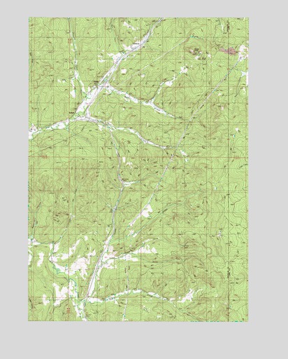
Curtin, OR USGS Topographic Map
Click on map above to begin viewing in our Map Viewer.

This topographic map contains these locations and features:
Feature Name Type Latitude Longitude GNIS ID View Map
AnlaufPopulated PlaceN43.7110°W123.2237°1136006View Map
Anlauf CreekStreamN43.6707°W123.2012°1133049View Map
Anlauf Post Office (historical)Post OfficeN43.7110°W123.2237°1164841View Map
Bear CreekStreamN43.7212°W123.2101°1117353View Map
Buck CreekStreamN43.7104°W123.2204°1118181View Map
ComstockPopulated PlaceN43.7393°W123.1865°1166632View Map
Comstock CemeteryCemeteryN43.7341°W123.1933°1116959View Map
Comstock Post Office (historical)Post OfficeN43.7393°W123.1865°1165079View Map
Cox CreekStreamN43.6326°W123.2215°1119442View Map
CurtinPopulated PlaceN43.7223°W123.2120°1119642View Map
Curtin Post OfficePost OfficeN43.7223°W123.2120°1165123View Map
Curtis CreekStreamN43.6490°W123.2087°1119643View Map
Cuttock ButteSummitN43.6610°W123.1387°1133032View Map
Doolittle ButteSummitN43.6340°W123.1339°1133030View Map
Gretna (historical)LocaleN43.7471°W123.1809°1166447View Map
Indian Burial GroundCemeteryN43.6512°W123.1845°1162611View Map
Lake DianeReservoirN43.7243°W123.2077°1162609View Map
Lawrence ReservoirReservoirN43.7323°W123.1843°1162610View Map
Lees CreekStreamN43.6576°W123.2048°1123028View Map
North Douglas County Fire and Emergency Medical Services Station 4BuildingN43.7228°W123.2090°2576908View Map
Pass Creek County ParkParkN43.7248°W123.2095°1133048View Map
Pheasant CreekStreamN43.7168°W123.2176°1125340View Map
Redford ButteSummitN43.6929°W123.1470°1133044View Map
Salt CreekStreamN43.6568°W123.2362°1126524View Map
Schafer CreekStreamN43.7110°W123.1756°1133047View Map
Seeley CreekStreamN43.7251°W123.2226°1126727View Map
Simpson CreekStreamN43.6587°W123.2487°1126993View Map
Siuslaw (historical)LocaleN43.7401°W123.1851°1166452View Map
Sliter ButteSummitN43.6430°W123.1315°1133031View Map
Spike Buck ButteSummitN43.6471°W123.1415°1133050View Map
Ward CreekStreamN43.7348°W123.1973°1128634View Map
Wards ButteSummitN43.7357°W123.1575°1128637View Map
Wehmeyer CreekStreamN43.6560°W123.2487°1128777View Map

Note: Coordinates in the location and feature list above are referenced to NAD83 datum.


Copyright (C) 2008-2025 Ryan Niemi / Sunset Dynamics ... All Rights Reserved