TopoQuest Logo
Do you find TopoQuest useful?
Help keep TopoQuest running and adding new maps/features by donating!
Bitcoin:  19c7KJd3qBynnjoSw5npx9KScwjBe4ifkT
Litecoin:  LXs6TkuXGGXo1vDsWCkWVdjQX94eUKd6ui
Home View Maps Find Maps Find Places Resources & Links


Cottondale East, Florida Topographic Map

USGS Map Title: Cottondale East, FL
USGS Map MRC: 30085G3
DRG (GeoTIFF) Download: o30085g3.tif


Neighboring USGS Topographic Map Quads:


  Campbellton, FL  
30085H4
 

  Sills, FL  
30085H3
 

  Malone, FL  
30085H2
 

  Cottondale West, FL  
30085G4
 

  Cottondale East, FL  
30085G3
 

  Marianna, FL  
30085G2
 

  Alford, FL  
30085F4
 

  Kynesville, FL  
30085F3
 

  Oakdale, FL  
30085F2


Map MRC Location:

N31°
W86°
N31°
W85°
H8 H7 H6 H5 H4 H3 H2 H1
G8 G7 G6 G5 G4 G3 G2 G1
F8 F7 F6 F5 F4 F3 F2 F1
E8 E7 E6 E5 E4 E3 E2 E1
D8 D7 D6 D5 D4 D3 D2 D1
C8 C7 C6 C5 C4 C3 C2 C1
B8 B7 B6 B5 B4 B3 B2 B1
A8 A7 A6 A5 A4 A3 A2 A1
N30°
W86°
N30°
W85°

Cottondale East, FL USGS 1:24K Topographic Map Preview:
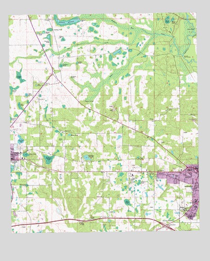
Cottondale East, FL USGS Topographic Map
Click on map above to begin viewing in our Map Viewer.

This topographic map contains these locations and features:
Feature Name Type Latitude Longitude GNIS ID View Map
Aero-Custom Airport (historical)AirportN30.8452°W85.2813°309363View Map
Antioch ChurchChurchN30.7830°W85.2877°277917View Map
Baker CreekStreamN30.8621°W85.2752°278049View Map
Bell PondSwampN30.7673°W85.2981°278430View Map
Bellamy BridgeBridgeN30.8657°W85.2513°278442View Map
Bethlehem SchoolSchoolN30.8080°W85.3383°278574View Map
Bonnet PondSwampN30.8327°W85.3730°279233View Map
Caney PondSwampN30.7995°W85.3716°279981View Map
Caraway Mill PondLakeN30.7563°W85.2677°280023View Map
Cold PondSwampN30.8030°W85.3402°280638View Map
Cottondale Elementary SchoolSchoolN30.7927°W85.3724°298472View Map
Cottondale High SchoolSchoolN30.7928°W85.3747°298471View Map
Dozier Training SchoolSchoolN30.7621°W85.2602°307105View Map
Finger PondLakeN30.8647°W85.3555°282453View Map
Frank PondSwampN30.7950°W85.3644°282790View Map
Gnat Hole PondSwampN30.8036°W85.3684°283129View Map
Guy PondSwampN30.8227°W85.3684°283572View Map
Jackson County Correctional FacilityBuildingN30.7648°W85.2585°2753105View Map
Jackson County Sheriff's OfficeBuildingN30.7849°W85.2616°2754509View Map
Jenkins PondLakeN30.8458°W85.3398°284749View Map
Jenkins PondSwampN30.7781°W85.2897°284750View Map
Lockey PondSwampN30.8398°W85.3682°285907View Map
Longview SchoolSchoolN30.8341°W85.3510°307104View Map
Magnolia ChurchChurchN30.8141°W85.2791°286296View Map
Marianna Fire Control Headquarters Fire TowerTowerN30.7824°W85.2705°300061View Map
Marianna Fire Department Station 16BuildingN30.7574°W85.2642°2644243View Map
Mary Ann PondSwampN30.7774°W85.3641°286479View Map
Mary PondLakeN30.8062°W85.3352°286486View Map
Maybet PondLakeN30.8649°W85.3517°286543View Map
McNealy PondSwampN30.7923°W85.3496°286649View Map
Middle PondLakeN30.8475°W85.3293°286809View Map
Mount Ararat ChurchChurchN30.7699°W85.3138°287199View Map
New Hope ChurchChurchN30.7832°W85.2824°287642View Map
Open PondLakeN30.8292°W85.3636°288174View Map
Red PondLakeN30.8346°W85.3566°289551View Map
Roulac PondLakeN30.8624°W85.3483°297765View Map
Roulhac PondLakeN30.8624°W85.3485°289992View Map
Russ Mill CreekStreamN30.8657°W85.2866°290069View Map
Saint Johns SchoolSchoolN30.8194°W85.2697°290242View Map
School Number 2SchoolN30.7752°W85.2533°290746View Map
Snelling PondSwampN30.8666°W85.3474°291305View Map
Springfield SchoolSchoolN30.8724°W85.3474°291575View Map
Swain PondLakeN30.8699°W85.2691°291919View Map
Tanner SpringsSpringN30.8255°W85.3250°292025View Map
Town of CottondaleCivilN30.7929°W85.3710°2406319View Map
Waddells MillPopulated PlaceN30.8705°W85.3255°295691View Map
Waddells Mill CreekStreamN30.8505°W85.2597°292812View Map
Waddells Mill PondReservoirN30.8704°W85.3361°292813View Map
Webbville SpringSpringN30.8392°W85.3343°292971View Map
White PondLakeN30.8712°W85.2657°293225View Map
Williams Mill PondLakeN30.7930°W85.3246°293334View Map
WJAQ-FM (Marianna)TowerN30.7838°W85.2549°309056View Map
WTOT-AM (Marianna)TowerN30.7838°W85.2549°308767View Map

Note: Coordinates in the location and feature list above are referenced to NAD83 datum.


Copyright (C) 2008-2024 Ryan Niemi / Sunset Dynamics ... All Rights Reserved