TopoQuest Logo
Do you find TopoQuest useful?
Help keep TopoQuest running and adding new maps/features by donating!
Bitcoin:  19c7KJd3qBynnjoSw5npx9KScwjBe4ifkT
Litecoin:  LXs6TkuXGGXo1vDsWCkWVdjQX94eUKd6ui
Home View Maps Find Maps Find Places Resources & Links


Kynesville, Florida Topographic Map

USGS Map Title: Kynesville, FL
USGS Map MRC: 30085F3
DRG (GeoTIFF) Download: o30085f3.tif


Neighboring USGS Topographic Map Quads:


  Cottondale West, FL  
30085G4
 

  Cottondale East, FL  
30085G3
 

  Marianna, FL  
30085G2
 

  Alford, FL  
30085F4
 

  Kynesville, FL  
30085F3
 

  Oakdale, FL  
30085F2
 

  Compass Lake, FL  
30085E4
 

  Alford SE, FL  
30085E3
 

  Altha West, FL  
30085E2


Map MRC Location:

N31°
W86°
N31°
W85°
H8 H7 H6 H5 H4 H3 H2 H1
G8 G7 G6 G5 G4 G3 G2 G1
F8 F7 F6 F5 F4 F3 F2 F1
E8 E7 E6 E5 E4 E3 E2 E1
D8 D7 D6 D5 D4 D3 D2 D1
C8 C7 C6 C5 C4 C3 C2 C1
B8 B7 B6 B5 B4 B3 B2 B1
A8 A7 A6 A5 A4 A3 A2 A1
N30°
W86°
N30°
W85°

Kynesville, FL USGS 1:24K Topographic Map Preview:
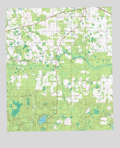
Kynesville, FL USGS Topographic Map
Click on map above to begin viewing in our Map Viewer.

This topographic map contains these locations and features:
Feature Name Type Latitude Longitude GNIS ID View Map
Alford DivisionCivilN30.6369°W85.3131°1935682View Map
Beech PondSwampN30.7213°W85.2629°278397View Map
Blue SinkBasinN30.6952°W85.2985°279061View Map
Bonnet SinkBasinN30.7027°W85.2777°279234View Map
Bright Prospect ChurchChurchN30.7171°W85.2766°279397View Map
Cave SpringSpringN30.7424°W85.2838°280166View Map
Cherokee SchoolSchoolN30.6596°W85.3158°280357View Map
Damascus ChurchChurchN30.7491°W85.2885°281268View Map
Ditch BranchStreamN30.6874°W85.2510°281594View Map
Double SpringSwampN30.7035°W85.3022°281718View Map
Foxworth Mill CreekStreamN30.6899°W85.2927°282777View Map
Gadsen SpringSpringN30.7024°W85.2880°282868View Map
Goose PondSwampN30.7197°W85.2809°283202View Map
Grady PondLakeN30.6465°W85.3175°283262View Map
Gum PondLakeN30.7212°W85.2573°283543View Map
Hickory Level ChurchChurchN30.6546°W85.2994°283965View Map
Jim Long BaySwampN30.6529°W85.3292°284803View Map
KynesvillePopulated PlaceN30.7313°W85.3547°294827View Map
Land's FieldAirportN30.6952°W85.3100°309648View Map
Little Dry CreekStreamN30.6932°W85.3638°285674View Map
McCormick CemeteryCemeteryN30.6335°W85.3269°286583View Map
McCormick LakeLakeN30.6366°W85.3331°286587View Map
Mill Pond SpringSpringN30.7044°W85.3072°286902View Map
Mount Olive ChurchChurchN30.7210°W85.3060°287276View Map
Mule SinkBasinN30.7010°W85.2724°287449View Map
New Salem ChurchChurchN30.7457°W85.3074°287689View Map
Pilcher PondLakeN30.6306°W85.2517°288812View Map
Pilgrim Rest ChurchChurchN30.6641°W85.3199°288814View Map
Pine Ridge ChurchChurchN30.6799°W85.3405°288914View Map
Rawles BaySwampN30.7113°W85.3524°289515View Map
Rum SinkBasinN30.7057°W85.2694°290052View Map
Sand PondLakeN30.6988°W85.3642°290574View Map
Schoolhouse PondSwampN30.7347°W85.2846°290754View Map
Schoolhouse PondLakeN30.7382°W85.2790°300070View Map
Scott ChurchChurchN30.6760°W85.2821°290760View Map
Shores Mill CreekStreamN30.6927°W85.3724°291079View Map
Spring LakeLakeN30.6998°W85.2852°291555View Map
Springboard SpringSwampN30.7066°W85.3055°291569View Map
Stump CreekStreamN30.6932°W85.3638°291759View Map
Taylor HoleSwampN30.7496°W85.2608°292072View Map
Tharp Mill PondLakeN30.7377°W85.3736°292145View Map
Victory CemeteryCemeteryN30.6619°W85.3491°292770View Map
Victory SwampSwampN30.6445°W85.3688°292772View Map
Woman SinkBasinN30.7021°W85.2708°293481View Map

Note: Coordinates in the location and feature list above are referenced to NAD83 datum.


Copyright (C) 2008-2025 Ryan Niemi / Sunset Dynamics ... All Rights Reserved