TopoQuest Logo
Do you find TopoQuest useful?
Help keep TopoQuest running and adding new maps/features by donating!
Bitcoin:  19c7KJd3qBynnjoSw5npx9KScwjBe4ifkT
Litecoin:  LXs6TkuXGGXo1vDsWCkWVdjQX94eUKd6ui
Home View Maps Find Maps Find Places Resources & Links


Oakdale, Florida Topographic Map

USGS Map Title: Oakdale, FL
USGS Map MRC: 30085F2
DRG (GeoTIFF) Download: o30085f2.tif


Neighboring USGS Topographic Map Quads:


  Cottondale East, FL  
30085G3
 

  Marianna, FL  
30085G2
 

  Dellwood, FL  
30085G1
 

  Kynesville, FL  
30085F3
 

  Oakdale, FL  
30085F2
 

  Cypress, FL  
30085F1
 

  Alford SE, FL  
30085E3
 

  Altha West, FL  
30085E2
 

  Altha East, FL  
30085E1


Map MRC Location:

N31°
W86°
N31°
W85°
H8 H7 H6 H5 H4 H3 H2 H1
G8 G7 G6 G5 G4 G3 G2 G1
F8 F7 F6 F5 F4 F3 F2 F1
E8 E7 E6 E5 E4 E3 E2 E1
D8 D7 D6 D5 D4 D3 D2 D1
C8 C7 C6 C5 C4 C3 C2 C1
B8 B7 B6 B5 B4 B3 B2 B1
A8 A7 A6 A5 A4 A3 A2 A1
N30°
W86°
N30°
W85°

Oakdale, FL USGS 1:24K Topographic Map Preview:
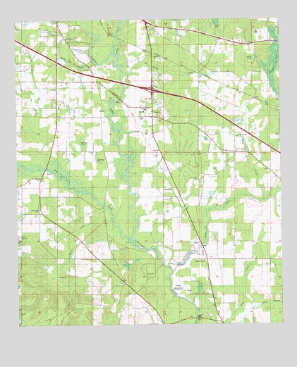
Oakdale, FL USGS Topographic Map
Click on map above to begin viewing in our Map Viewer.

This topographic map contains these locations and features:
Feature Name Type Latitude Longitude GNIS ID View Map
Bellamy PondLakeN30.6999°W85.2196°278444View Map
Braxton CemeteryCemeteryN30.7352°W85.1844°279345View Map
Bridge CreekStreamN30.7263°W85.1999°279384View Map
Buck Pelt BranchStreamN30.7332°W85.2130°279583View Map
Clair PondLakeN30.7340°W85.1371°280477View Map
Douglas PondSwampN30.7319°W85.1270°281726View Map
Dry CreekStreamN30.6577°W85.1944°281795View Map
Elder CemeteryCemeteryN30.6460°W85.1894°282144View Map
Gable BranchStreamN30.6313°W85.1380°282865View Map
Grant CemeteryCemeteryN30.7105°W85.1916°283281View Map
Holly Grove ChurchChurchN30.7252°W85.2308°284169View Map
Hope SchoolSchoolN30.7128°W85.1893°300067View Map
Jerusalem CemeteryCemeteryN30.6935°W85.2124°284771View Map
Lipford CemeteryCemeteryN30.6607°W85.2499°285572View Map
Little Rocky CemeteryCemeteryN30.6849°W85.1644°285794View Map
Little Rocky CreekStreamN30.6757°W85.1333°285796View Map
Little Rocky Creek ChurchChurchN30.6963°W85.1416°285799View Map
Little Rocky Creek SchoolSchoolN30.6960°W85.1638°285800View Map
Long BranchStreamN30.6899°W85.2369°285973View Map
Long Branch SchoolSchoolN30.7149°W85.2310°285978View Map
Maddox SloughGutN30.7382°W85.1841°286265View Map
Magnolia SchoolSchoolN30.7130°W85.1888°286306View Map
Mills ChurchChurchN30.6852°W85.2388°286934View Map
Mount Cello ChurchChurchN30.6957°W85.1627°287214View Map
New Union ChurchChurchN30.6730°W85.2396°294428View Map
OakdalePopulated PlaceN30.7105°W85.1852°294869View Map
Pelt CemeteryCemeteryN30.7299°W85.2144°288683View Map
Pelt CreekStreamN30.6730°W85.2071°288684View Map
Pittman Hill ChurchChurchN30.6566°W85.2360°289005View Map
Pledger CemeteryCemeteryN30.6449°W85.2260°289082View Map
Rock CreekPopulated PlaceN30.6519°W85.1602°295582View Map
Rocky CreekStreamN30.6469°W85.1758°289897View Map
SesaLocaleN30.7413°W85.1872°300069View Map
Sims CemeteryCemeteryN30.6957°W85.1838°291163View Map
SimsvillePopulated PlaceN30.6807°W85.1741°294926View Map
Spring CreekStreamN30.7355°W85.2013°291529View Map
StarPopulated PlaceN30.7177°W85.1366°300066View Map
Union CityLocaleN30.6346°W85.1574°300068View Map
United ChurchChurchN30.6852°W85.2383°300065View Map

Note: Coordinates in the location and feature list above are referenced to NAD83 datum.


Copyright (C) 2008-2025 Ryan Niemi / Sunset Dynamics ... All Rights Reserved