TopoQuest Logo
Do you find TopoQuest useful?
Help keep TopoQuest running and adding new maps/features by donating!
Bitcoin:  19c7KJd3qBynnjoSw5npx9KScwjBe4ifkT
Litecoin:  LXs6TkuXGGXo1vDsWCkWVdjQX94eUKd6ui
Home View Maps Find Maps Find Places Resources & Links


Cottonwood Reservoir, Montana Topographic Map

USGS Map Title: Cottonwood Reservoir, MT
USGS Map MRC: 46110A6
DRG (GeoTIFF) Download: o46110a6.tif


Neighboring USGS Topographic Map Quads:


  Sixteen NE, MT  
46110B7
 

  Wolf Hill, MT  
46110B6
 

  Scab Rock Mountain, MT  
46110B5
 

  Wallrock, MT  
46110A7
 

  Cottonwood Reservoir, MT  
46110A6
 

  Lena Creek, MT  
46110A5
 

  Sedan, MT  
45110H7
 

  Wilsall, MT  
45110H6
 

  Clyde Park, MT  
45110H5


Map MRC Location:

N47°
W111°
N47°
W110°
H8 H7 H6 H5 H4 H3 H2 H1
G8 G7 G6 G5 G4 G3 G2 G1
F8 F7 F6 F5 F4 F3 F2 F1
E8 E7 E6 E5 E4 E3 E2 E1
D8 D7 D6 D5 D4 D3 D2 D1
C8 C7 C6 C5 C4 C3 C2 C1
B8 B7 B6 B5 B4 B3 B2 B1
A8 A7 A6 A5 A4 A3 A2 A1
N46°
W111°
N46°
W110°

Cottonwood Reservoir, MT USGS 1:24K Topographic Map Preview:
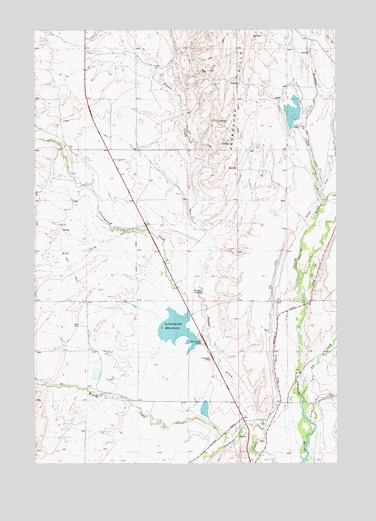
Cottonwood Reservoir, MT USGS Topographic Map
Click on map above to begin viewing in our Map Viewer.

This topographic map contains these locations and features:
Feature Name Type Latitude Longitude GNIS ID View Map
03N08E04A___01 WellWellN46.0435°W110.7324°813840View Map
03N08E10C___01 WellWellN46.0219°W110.7219°813781View Map
03N09E07B___01 WellWellN46.0288°W110.6599°813807View Map
03N09E08C___01 WellWellN46.0216°W110.6391°813780View Map
03N09E08D___01 WellWellN46.0216°W110.6285°813779View Map
04N08E09A___01 WellWellN46.1144°W110.7338°814054View Map
04N08E27A___01 WellWellN46.0710°W110.7130°813917View Map
04N09E31B___01 WellWellN46.0569°W110.6608°813873View Map
04N09E32C___01 WellWellN46.0497°W110.6402°813855View Map
Antelope CreekStreamN46.0741°W110.6319°768287View Map
Big CanalCanalN46.0738°W110.6480°768756View Map
Cottonwood CreekStreamN46.0344°W110.6797°770174View Map
Cottonwood DamDamN46.0349°W110.6824°794987View Map
Cottonwood ReservoirReservoirN46.0386°W110.6918°770196View Map
Daisy Dean CreekStreamN46.0122°W110.6366°770428View Map
Elk CreekStreamN46.0208°W110.6397°771188View Map
Jordan DamDamN46.0999°W110.6441°795327View Map
Kaiser DamDamN46.0149°W110.6808°795325View Map
Kavanaugh HillsSummitN46.1077°W110.6669°772943View Map
Landers Number 1 DamDamN46.0249°W110.7258°798789View Map
Meyersburg (historical)Populated PlaceN46.0110°W110.6633°1743385View Map
Meyersburg Post Office (historical)Post OfficeN46.0110°W110.6633°1743384View Map
Muddy CreekStreamN46.0083°W110.6719°774485View Map
Myers DitchCanalN46.0730°W110.6358°774534View Map
Potter CreekStreamN46.0113°W110.6558°775402View Map
Rice CreekStreamN46.0666°W110.7135°775741View Map
Sheilds CanyonCanalN46.0035°W110.6599°776464View Map
Wilsall AirportAirportN46.0503°W110.6855°806551View Map

Note: Coordinates in the location and feature list above are referenced to NAD83 datum.


Copyright (C) 2008-2024 Ryan Niemi / Sunset Dynamics ... All Rights Reserved