TopoQuest Logo
Do you find TopoQuest useful?
Help keep TopoQuest running and adding new maps/features by donating!
Bitcoin:  19c7KJd3qBynnjoSw5npx9KScwjBe4ifkT
Litecoin:  LXs6TkuXGGXo1vDsWCkWVdjQX94eUKd6ui
Home View Maps Find Maps Find Places Resources & Links


Angels Camp, California Topographic Map

USGS Map Title: Angels Camp, CA
USGS Map MRC: 38120A5
DRG (GeoTIFF) Download: o38120a5.tif


Neighboring USGS Topographic Map Quads:


  San Andreas, CA  
38120B6
 

  Calaveritas, CA  
38120B5
 

  Murphys, CA  
38120B4
 

  Salt Spring Valley, CA  
38120A6
 

  Angels Camp, CA  
38120A5
 

  Columbia, CA  
38120A4
 

  Copperopolis, CA  
37120H6
 

  New Melones Dam, CA  
37120H5
 

  Sonora, CA  
37120H4


Map MRC Location:

N39°
W121°
N39°
W120°
H8 H7 H6 H5 H4 H3 H2 H1
G8 G7 G6 G5 G4 G3 G2 G1
F8 F7 F6 F5 F4 F3 F2 F1
E8 E7 E6 E5 E4 E3 E2 E1
D8 D7 D6 D5 D4 D3 D2 D1
C8 C7 C6 C5 C4 C3 C2 C1
B8 B7 B6 B5 B4 B3 B2 B1
A8 A7 A6 A5 A4 A3 A2 A1
N38°
W121°
N38°
W120°

Angels Camp, CA USGS 1:24K Topographic Map Preview:
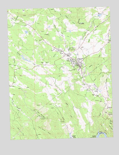
Angels Camp, CA USGS Topographic Map
Click on map above to begin viewing in our Map Viewer.

This topographic map contains these locations and features:
Feature Name Type Latitude Longitude GNIS ID View Map
Adelia MineMineN38.0613°W120.5633°1675764View Map
Aetna Shaft MineMineN38.0846°W120.5441°1675765View Map
Airola MineMineN38.0652°W120.5160°1675766View Map
Albany FlatFlatN38.0494°W120.5285°233405View Map
Alcoyne MineMineN38.1144°W120.5596°1675708View Map
AltavillePopulated PlaceN38.0838°W120.5619°1659688View Map
Altaville Catholic CemeteryCemeteryN38.0772°W120.5603°1804918View Map
Altaville Grammar SchoolSchoolN38.0830°W120.5619°1804902View Map
Altaville Melones Fire Protection DistrictBuildingN38.0806°W120.5574°2624495View Map
Altaville MineMineN38.0805°W120.5552°1675767View Map
Altaville MineMineN38.1019°W120.5558°1675709View Map
Altaville Post OfficePost OfficeN38.0783°W120.5528°1804903View Map
Altaville Protestant CemeteryCemeteryN38.0791°W120.5588°1804904View Map
Altaville Serbian CemeteryCemeteryN38.0767°W120.5620°1804950View Map
Altaville State Historic LandmarkParkN38.0830°W120.5594°1804905View Map
American Legion Ambulance Station 24BuildingN38.0706°W120.5422°2662161View Map
Angels CampPopulated PlaceN38.0683°W120.5396°1667877View Map
Angels Camp Branch Calaveras County LibraryBuildingN38.0713°W120.5419°1804906View Map
Angels Camp City HallBuildingN38.0766°W120.5494°1804907View Map
Angels Camp MuseumBuildingN38.0760°W120.5474°1804908View Map
Angels Camp Police DepartmentBuildingN38.0804°W120.5593°2755883View Map
Angels Camp Post OfficePost OfficeN38.0694°W120.5404°1804909View Map
Angels Camp Towne Center Shopping CenterLocaleN38.0805°W120.5558°1804910View Map
Angels City DivisionCivilN38.0257°W120.6076°1935010View Map
Angels Deep MineMineN38.0733°W120.5530°1675768View Map
Angels MineMineN38.0758°W120.5483°233418View Map
Bald HillSummitN38.0855°W120.5474°233453View Map
Bear MountainSummitN38.0194°W120.5838°233466View Map
Belmont Osborn MineMineN38.0766°W120.5813°1675769View Map
Benson MineMineN38.0796°W120.5855°1675770View Map
Big Spring MineMineN38.0510°W120.5330°1675710View Map
Black Oak MineMineN38.0944°W120.5888°233510View Map
Bolitha MineMineN38.0541°W120.5324°1675711View Map
Bret Harte Union High SchoolSchoolN38.0790°W120.5527°233545View Map
Brower CreekStreamN38.0391°W120.5613°233549View Map
Brown MineMineN38.0158°W120.5060°1675712View Map
Bruner MineMineN38.0455°W120.5277°233553View Map
Brunner HillSummitN38.0991°W120.5785°233554View Map
Bullion MineMineN38.0469°W120.5294°233573View Map
Bully Boy MineMineN38.1219°W120.5716°1675713View Map
Calaveras Central MineMineN38.0863°W120.5469°233597View Map
Calaveras MineMineN38.0135°W120.5019°233598View Map
California Ophir MineMineN38.0277°W120.5088°1675714View Map
Calmo MineMineN38.0849°W120.5344°1675771View Map
Calmo Number Two MineMineN38.0830°W120.5285°1675772View Map
Canepa MineMineN38.0849°W120.5121°1675773View Map
Canepa MineMineN38.0238°W120.5202°1675715View Map
Carson CreekStreamN38.0077°W120.5183°233638View Map
Carson FlatFlatN38.0396°W120.5163°233639View Map
Carson HillSummitN38.0216°W120.5033°266539View Map
Carson HillPopulated PlaceN38.0283°W120.5066°233640View Map
Champion MineMineN38.0724°W120.5808°233653View Map
Chapparal Hill MineMineN38.0330°W120.5180°1675716View Map
Cherokee 509 DamDamN38.0799°W120.6094°1663922View Map
Cherokee FlatFlatN38.0838°W120.5677°233658View Map
Cherokee MineMineN38.0844°W120.5746°233659View Map
Church of ChristChurchN38.0866°W120.5696°1804919View Map
City of AngelsCivilN38.0707°W120.5501°2409709View Map
City of Angels Fire Department Station 1 HeadquartersBuildingN38.0689°W120.5374°2623682View Map
City of Angels Fire Department Station 2BuildingN38.0806°W120.5592°2624652View Map
Claude ProspectMineN38.0399°W120.5358°1675717View Map
Clifton Ranch MineMineN38.0860°W120.5638°1675774View Map
Columbia MineMineN38.0391°W120.5219°1675718View Map
Coopers CreekStreamN38.1108°W120.6216°233712View Map
Copello ParkParkN38.0869°W120.5708°1804923View Map
Crosette ProspectMineN38.0819°W120.6160°1675719View Map
Crystal MineMineN38.0730°W120.5458°1675775View Map
Curiosity MineMineN38.0613°W120.5708°1675776View Map
Curtis MineMineN38.0852°W120.5744°1675777View Map
Davis ProspectMineN38.0063°W120.6177°1675720View Map
Dead Horse MineMineN38.0744°W120.5438°1675778View Map
Demarest MineMineN38.0752°W120.5560°1675779View Map
Department of Forestry and Fire Protection Altaville StationBuildingN38.0830°W120.5614°2624577View Map
Dolling MineMineN38.0649°W120.5494°233791View Map
Etna King MineMineN38.0677°W120.5460°1675780View Map
Evening Star MineMineN38.0694°W120.5699°1675781View Map
Finnegan MineMineN38.0235°W120.5038°1675723View Map
First Baptist ChurchChurchN38.0713°W120.5377°1804927View Map
Foster MineMineN38.0752°W120.5446°1675782View Map
Fowler LookoutLocaleN38.0194°W120.5838°233895View Map
Frog Town Airport (historical)AirportN38.0497°W120.5208°2106450View Map
FrogtownLocaleN38.0463°W120.5185°233912View Map
Garibaldi MineMineN38.0919°W120.5966°1675721View Map
German RidgeRidgeN38.1119°W120.5396°233922View Map
Ghost MineMineN38.0669°W120.5349°1675783View Map
Gold Cliff MineMineN38.0660°W120.5458°233936View Map
Gold Hill MineMineN38.0721°W120.5749°1675784View Map
Gold Hill MineMineN38.0408°W120.5238°1675722View Map
Golden Star MineMineN38.0533°W120.5249°1675724View Map
Great Western MineMineN38.0791°W120.5496°1675785View Map
Greenhorn GulchValleyN38.0444°W120.5610°233959View Map
Greenstone MineMineN38.0633°W120.5346°1675786View Map
Hale MineMineN38.0716°W120.5530°1675787View Map
Hardy MineMineN38.0358°W120.5174°233984View Map
Hicks ProspectMineN38.0458°W120.5385°1675725View Map
Hogate MineMineN38.1241°W120.5660°1675726View Map
Holman 2006 DamDamN38.0499°W120.5394°1664440View Map
Holy Ghost MineMineN38.0649°W120.5313°1675788View Map
Imperial MineMineN38.0219°W120.5188°1675727View Map
Indian CreekStreamN38.0571°W120.5371°266846View Map
Indian GulchValleyN38.0083°W120.5013°234070View Map
Iron Rock MineMineN38.0271°W120.5083°1675728View Map
Jack Rabbit MineMineN38.1085°W120.5630°1675729View Map
Jones MineMineN38.0091°W120.5191°1675730View Map
Jupiter DitchCanalN38.0985°W120.5583°234101View Map
Jupiter MineMineN38.1096°W120.5402°234102View Map
Kentucky MineMineN38.0871°W120.5077°1675789View Map
Keystone MineMineN38.0874°W120.5694°1675790View Map
Kiefer ReservoirReservoirN38.1095°W120.5366°234109View Map
Last Chance MineMineN38.0663°W120.5366°1675791View Map
Lavagnino MineMineN38.0591°W120.5463°1675792View Map
Lightner MineMineN38.0727°W120.5474°234158View Map
Lindsay MineMineN38.0694°W120.5527°1675793View Map
Lode CemeteryCemeteryN38.0783°W120.5594°1804931View Map
Lone GulchValleyN38.1088°W120.6116°234186View Map
Longworth MineMineN38.0652°W120.5691°1675794View Map
Mable Fay MineMineN38.0641°W120.5696°1675795View Map
Madison MineMineN38.0630°W120.5416°1675796View Map
Maloney ProspectMineN38.1121°W120.6071°1675731View Map
Maltman MineMineN38.0785°W120.5494°1675797View Map
Marble Spring MineMineN38.0516°W120.5330°234242View Map
Marble Springs MineMineN38.0466°W120.5291°1675732View Map
Mark Twain Elementary SchoolSchoolN38.0751°W120.5505°234246View Map
Mark Twain MonumentParkN38.0730°W120.5435°1804932View Map
Mattison MineMineN38.0852°W120.5530°234251View Map
McElroy MineMineN38.0846°W120.5505°1675798View Map
Meeker MineMineN38.0296°W120.5119°1675733View Map
Middletons Mark Twain Shopping CenterLocaleN38.0763°W120.5488°1804935View Map
Mike Brown MineMineN38.0833°W120.5463°1675799View Map
Missouri MineMineN38.0394°W120.5183°1675734View Map
Mohawk MineMineN38.0727°W120.5805°1675800View Map
Morgan MineMineN38.0246°W120.5096°234328View Map
Morning Star MineMineN38.0480°W120.5294°1675735View Map
Mother Lode Service Center HeliportAirportN38.0830°W120.5421°1653219View Map
Nassau ValleyValleyN38.0405°W120.6244°234354View Map
Negro HillSummitN38.0730°W120.5877°1659764View Map
Nellie MineMineN38.0488°W120.5260°1675736View Map
New Year MineMineN38.0219°W120.5069°1675737View Map
North Star MineMineN38.0905°W120.5524°1675801View Map
North Star MineMineN38.0683°W120.5471°234386View Map
North Star MineMineN38.0269°W120.5038°1675738View Map
Nugget MineMineN38.0646°W120.5696°1675802View Map
Ohio MineMineN38.0333°W120.5166°1675739View Map
Oriole MineMineN38.0535°W120.5374°1675740View Map
Ozark MineMineN38.0916°W120.5116°1675741View Map
Panuga MineMineN38.0894°W120.5802°1675803View Map
Parnell MineMineN38.0780°W120.5841°1675804View Map
Pedit ProspectMineN38.0488°W120.5399°1675742View Map
Peirano Ranch MineMineN38.0535°W120.5055°1675743View Map
Pierano QuarryMineN38.0866°W120.5377°234459View Map
Pine Nut MineMineN38.0916°W120.5841°1675744View Map
Port Arthur MineMineN38.0758°W120.5627°1675805View Map
Prince Garibardi BuildingBuildingN38.0791°W120.5538°1804942View Map
Pure Quill MineMineN38.0569°W120.5563°1675806View Map
Relief MineMineN38.0246°W120.5096°1675745View Map
Reserve MineMineN38.0227°W120.5044°234560View Map
Riesler Ranch MineMineN38.0674°W120.5733°1675807View Map
Romaggi AdobeBuildingN38.0410°W120.5221°234587View Map
Romaggi and Costa MineMineN38.0435°W120.5263°1675746View Map
Romaggi Family MineMineN38.0424°W120.5246°1675747View Map
Ross 99-003 DamDamN38.1165°W120.5150°1663689View Map
Ross ReservoirReservoirN38.1170°W120.5136°255120View Map
Russell MineMineN38.0588°W120.5408°1675808View Map
Sacramento MineMineN38.0805°W120.5691°1675809View Map
Safe Deposit MineMineN38.0805°W120.5863°1675810View Map
Saint Patricks Catholic ChurchChurchN38.0752°W120.5449°1804946View Map
San Domingo MineMineN38.1210°W120.5785°1675748View Map
Santa Ana MineMineN38.0366°W120.5133°1675749View Map
Santa Cruz MineMineN38.0152°W120.5038°1675750View Map
Seventh Day Adventist ChurchChurchN38.0758°W120.5469°1804951View Map
Six Mile RanchLocaleN38.1038°W120.5002°266220View Map
Sixmile CreekStreamN38.0571°W120.5424°267254View Map
Soltana MineMineN38.0733°W120.5496°1675811View Map
Starve Out MineMineN38.0830°W120.5508°1675812View Map
Stelte ParkParkN38.0777°W120.5349°1804952View Map
Stevens MineMineN38.0216°W120.5071°1675751View Map
Stickles MineMineN38.0713°W120.5413°1675813View Map
Stone ProspectMineN38.0077°W120.6121°1675752View Map
Storm King MineMineN38.0510°W120.5269°1675753View Map
Thompson CreekStreamN38.0419°W120.5596°236263View Map
Thompson RanchLocaleN38.0505°W120.5874°1675754View Map
Triple Load MineMineN38.0669°W120.5666°1675814View Map
Tulloch MineMineN38.0352°W120.5146°236615View Map
Union Congregational ChurchChurchN38.0733°W120.5427°1804954View Map
Union MineMineN38.0233°W120.5060°1675756View Map
Utica MineMineN38.0705°W120.5396°236942View Map
Utica ParkParkN38.0733°W120.5438°1804955View Map
Val Ranch ProspectMineN38.0960°W120.5144°1675757View Map
Vallecito Western MineMineN38.0924°W120.5013°236961View Map
Vanderbilt MineMineN38.0310°W120.5127°1675758View Map
Vonich GulchValleyN38.0048°W120.5542°237132View Map
Vonich MineMineN38.0160°W120.5599°237133View Map
Wagon Rut MineMineN38.0708°W120.5719°1675815View Map
Waterman MineMineN38.0594°W120.5394°1675816View Map
Whittle MineMineN38.0288°W120.5255°1675759View Map
Yellowstone MineMineN38.0816°W120.5869°1675817View Map

Note: Coordinates in the location and feature list above are referenced to NAD83 datum.


Copyright (C) 2008-2024 Ryan Niemi / Sunset Dynamics ... All Rights Reserved