TopoQuest Logo
Do you find TopoQuest useful?
Help keep TopoQuest running and adding new maps/features by donating!
Bitcoin:  19c7KJd3qBynnjoSw5npx9KScwjBe4ifkT
Litecoin:  LXs6TkuXGGXo1vDsWCkWVdjQX94eUKd6ui
Home View Maps Find Maps Find Places Resources & Links


Council, Arkansas Topographic Map

USGS Map Title: Council, AR
USGS Map MRC: 34090G4
DRG (GeoTIFF) Download: o34090g4.tif


Neighboring USGS Topographic Map Quads:


  Mud Lake, AR  
34090H5
 

  Hughes, AR  
34090H4
 

  Horseshoe Lake, AR  
34090H3
 

  Brickeys, AR  
34090G5
 

  Council, AR  
34090G4
 

  Robinsonville, MS  
34090G3
 

  Stubbs Island, MS  
34090F5
 

  Tunica, MS  
34090F4
 

  Hollywood, MS  
34090F3


Map MRC Location:

N35°
W91°
N35°
W90°
H8 H7 H6 H5 H4 H3 H2 H1
G8 G7 G6 G5 G4 G3 G2 G1
F8 F7 F6 F5 F4 F3 F2 F1
E8 E7 E6 E5 E4 E3 E2 E1
D8 D7 D6 D5 D4 D3 D2 D1
C8 C7 C6 C5 C4 C3 C2 C1
B8 B7 B6 B5 B4 B3 B2 B1
A8 A7 A6 A5 A4 A3 A2 A1
N34°
W91°
N34°
W90°

Council, AR USGS 1:24K Topographic Map Preview:
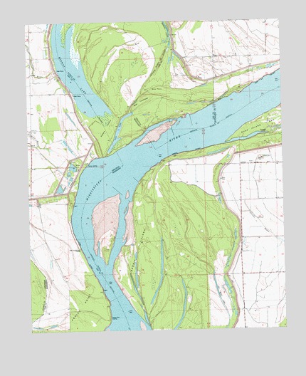
Council, AR USGS Topographic Map
Click on map above to begin viewing in our Map Viewer.

This topographic map contains these locations and features:
Feature Name Type Latitude Longitude GNIS ID View Map
Anderson FarmLocaleN34.8573°W90.3882°76171View Map
Ashley PointAreaN34.7682°W90.4654°45957View Map
Ashley Point LodgeLocaleN34.7545°W90.4607°45958View Map
Basket BarBarN34.8404°W90.4079°46133View Map
Basket Bar DikesLeveeN34.8318°W90.4293°70031View Map
Blue PointCapeN34.8462°W90.4398°667317View Map
Blue PointAreaN34.8479°W90.4393°46757View Map
Blue Point FarmLocaleN34.8729°W90.4495°667318View Map
Campbell BarBarN34.8037°W90.4787°81365View Map
Cistern Hill ChurchChurchN34.7940°W90.3865°668493View Map
Clark TowheadAreaN34.7618°W90.4318°668517View Map
Commerce Cut OffBendN34.8348°W90.4351°47945View Map
Commerce CutoffChannelN34.8209°W90.4434°706978View Map
Commerce LandingPopulated PlaceN34.8320°W90.3848°691780View Map
Commerce RevetmentLeveeN34.8223°W90.4276°668725View Map
CouncilPopulated PlaceN34.8723°W90.4895°76688View Map
Council BendBendN34.8020°W90.4715°706979View Map
Council IslandIslandN34.8501°W90.4668°684836View Map
Diamond WoodsAreaN34.7770°W90.4837°48505View Map
Gospel TempleChurchN34.8173°W90.3934°670552View Map
Happy CemeteryCemeteryN34.8598°W90.4076°49832View Map
Happy ChurchChurchN34.8595°W90.4087°49834View Map
Hopewell ChurchChurchN34.7820°W90.3951°671444View Map
Hopewell SchoolSchoolN34.7815°W90.3954°671451View Map
Lady Lee-Campbell LandingLocaleN34.7840°W90.4751°59564View Map
Mac TowheadAreaN34.8412°W90.4445°672981View Map
McDaniels FarmLocaleN34.8626°W90.4115°51818View Map
McPete SchoolSchoolN34.7582°W90.3973°673426View Map
Midway LakeLakeN34.8487°W90.4728°668859View Map
Mount Olive ChurchChurchN34.8168°W90.3823°674169View Map
New Mount Zion SchoolSchoolN34.8604°W90.4004°52728View Map
Old River LakeLakeN34.7674°W90.4088°675239View Map
Perry FarmLocaleN34.7582°W90.3862°675627View Map
PetersPopulated PlaceN34.8195°W90.4790°58350View Map
Peters CemeteryCemeteryN34.8315°W90.4970°70039View Map
Peters ChurchChurchN34.8315°W90.4976°53304View Map
Peters IslandIslandN34.8345°W90.4554°675651View Map
Peters IslandIslandN34.8276°W90.4623°81381View Map
Peters LandingLocaleN34.8177°W90.4701°66423View Map
Peters RevetmentLeveeN34.7798°W90.4726°59569View Map
Polk LandingLocaleN34.8293°W90.3779°684868View Map
Porter Lake RevetmentLeveeN34.8520°W90.3829°67815View Map
Rabbit IslandIslandN34.7818°W90.4440°676447View Map
Rosenwald School (historical)SchoolN34.8673°W90.4984°70040View Map
Township of CouncilCivilN34.8220°W90.4775°66806View Map

Note: Coordinates in the location and feature list above are referenced to NAD83 datum.


Copyright (C) 2008-2025 Ryan Niemi / Sunset Dynamics ... All Rights Reserved