TopoQuest Logo
Do you find TopoQuest useful?
Help keep TopoQuest running and adding new maps/features by donating!
Bitcoin:  19c7KJd3qBynnjoSw5npx9KScwjBe4ifkT
Litecoin:  LXs6TkuXGGXo1vDsWCkWVdjQX94eUKd6ui
Home View Maps Find Maps Find Places Resources & Links


Robinsonville, Mississippi Topographic Map

USGS Map Title: Robinsonville, MS
USGS Map MRC: 34090G3
DRG (GeoTIFF) Download: o34090g3.tif


Neighboring USGS Topographic Map Quads:


  Hughes, AR  
34090H4
 

  Horseshoe Lake, AR  
34090H3
 

  Lake Cormorant, MS  
34090H2
 

  Council, AR  
34090G4
 

  Robinsonville, MS  
34090G3
 

  Banks, MS  
34090G2
 

  Tunica, MS  
34090F4
 

  Hollywood, MS  
34090F3
 

  Arkabutla West, MS  
34090F2


Map MRC Location:

N35°
W91°
N35°
W90°
H8 H7 H6 H5 H4 H3 H2 H1
G8 G7 G6 G5 G4 G3 G2 G1
F8 F7 F6 F5 F4 F3 F2 F1
E8 E7 E6 E5 E4 E3 E2 E1
D8 D7 D6 D5 D4 D3 D2 D1
C8 C7 C6 C5 C4 C3 C2 C1
B8 B7 B6 B5 B4 B3 B2 B1
A8 A7 A6 A5 A4 A3 A2 A1
N34°
W91°
N34°
W90°

Robinsonville, MS USGS 1:24K Topographic Map Preview:
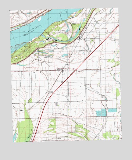
Robinsonville, MS USGS Topographic Map
Click on map above to begin viewing in our Map Viewer.

This topographic map contains these locations and features:
Feature Name Type Latitude Longitude GNIS ID View Map
Acres FarmLocaleN34.8145°W90.2815°666141View Map
Bennet FarmLocaleN34.8387°W90.3357°666823View Map
Bethlehem CemeteryCemeteryN34.8012°W90.2951°666985View Map
Bethlehem ChurchChurchN34.7901°W90.2957°667025View Map
BowdrePopulated PlaceN34.7968°W90.3323°667471View Map
Bowies PointCapeN34.8543°W90.3384°684832View Map
Buck Island BarBarN34.8504°W90.3579°667733View Map
Buck Island BayouLakeN34.8405°W90.2796°667734View Map
Buck Island Number 53FlatN34.8554°W90.3151°81981View Map
ClackPopulated PlaceN34.8459°W90.2932°668497View Map
CommercePopulated PlaceN34.8179°W90.3709°668724View Map
Crystal Spring ChurchChurchN34.7901°W90.3395°669003View Map
Crystal Springs SchoolSchoolN34.7898°W90.3384°669004View Map
Dales PointCapeN34.8454°W90.3059°684839View Map
Dalkhorn ChurchChurchN34.8626°W90.2751°690263View Map
Dalkhorn SchoolSchoolN34.8620°W90.2754°690264View Map
Donaldson SchoolSchoolN34.7684°W90.3032°669327View Map
Dry BayouGutN34.7629°W90.2801°669388View Map
Erwin Company FarmLocaleN34.8315°W90.2907°669805View Map
Eureka Plantation (historical)LocaleN34.8154°W90.2695°684846View Map
Fish Lake BayouLakeN34.8347°W90.3393°669989View Map
Fletcher BayouLakeN34.7822°W90.3714°670035View Map
Floyd BayouGutN34.7712°W90.3090°670062View Map
Flynn FarmLocaleN34.7509°W90.3459°670064View Map
Good Hope ChurchChurchN34.7726°W90.2623°670488View Map
Gum PondLakeN34.8062°W90.3212°670795View Map
Herron BayouGutN34.7809°W90.3107°671134View Map
Hollywood BrakeCanalN34.7645°W90.3557°1965309View Map
Indian CreekStreamN34.7790°W90.3593°671680View Map
Indian Creek BayouCanalN34.8245°W90.3107°1965310View Map
Indian Creek Plantation (historical)LocaleN34.8182°W90.3307°684850View Map
Indian Creek SchoolSchoolN34.8173°W90.3387°671692View Map
Johnson Chapel CemeteryCemeteryN34.8026°W90.2906°684851View Map
Johnson Church (historical)ChurchN34.8173°W90.2901°684852View Map
Kirby PlantationLocaleN34.8448°W90.2723°672183View Map
Leatherman PlantationLocaleN34.8168°W90.3648°672346View Map
Macedonia ChurchChurchN34.7504°W90.3570°673033View Map
Mary Mac Plantation (historical)LocaleN34.7993°W90.3454°684857View Map
Morning Star CemeteryCemeteryN34.8434°W90.2662°673823View Map
Morning Star ChurchChurchN34.8223°W90.2715°673847View Map
Mount Olive CemeteryCemeteryN34.8295°W90.3329°684859View Map
Mount Olive ChurchChurchN34.8173°W90.3393°684860View Map
Mount Zion ChurchChurchN34.8107°W90.3162°674408View Map
Murphy FarmLocaleN34.7904°W90.2790°674484View Map
North Tunica County Fire and Rescue DepartmentBuildingN34.8167°W90.3310°2665675View Map
Old River LakeLakeN34.8445°W90.3163°675238View Map
Owen FarmLocaleN34.7951°W90.3020°675343View Map
Owen FarmLocaleN34.7968°W90.3395°675344View Map
PentonPopulated PlaceN34.8659°W90.2798°690373View Map
Pickett Revetment (historical)LeveeN34.8665°W90.3020°690377View Map
Pleasant Grove ChurchChurchN34.7962°W90.2784°676047View Map
Polk Landing RevetmentLeveeN34.8320°W90.3659°676183View Map
Porter Lake DikesLeveeN34.8657°W90.3443°70249View Map
Rainey CemeteryCemeteryN34.7529°W90.3251°676457View Map
RobinsonvillePopulated PlaceN34.8173°W90.3162°676733View Map
Robinsonville Post OfficePost OfficeN34.8202°W90.3149°2768685View Map
Saint Johns ChurchChurchN34.8073°W90.3251°677092View Map
Saint Peters CemeteryCemeteryN34.8326°W90.3470°684872View Map
Saint Peters ChurchChurchN34.8226°W90.3429°677248View Map
Simual ChurchChurchN34.8462°W90.2965°677840View Map
Strunger BayouGutN34.7701°W90.2559°678373View Map
Supervisor District 1CivilN34.8060°W90.3486°712105View Map
Tatum SchoolSchoolN34.8173°W90.2909°678580View Map
Tunica ResortsPopulated PlaceN34.8361°W90.3472°2652410View Map
Tunica Resorts Census Designated PlaceCensusN34.8298°W90.3217°2586612View Map

Note: Coordinates in the location and feature list above are referenced to NAD83 datum.


Copyright (C) 2008-2025 Ryan Niemi / Sunset Dynamics ... All Rights Reserved