TopoQuest Logo
Do you find TopoQuest useful?
Help keep TopoQuest running and adding new maps/features by donating!
Bitcoin:  19c7KJd3qBynnjoSw5npx9KScwjBe4ifkT
Litecoin:  LXs6TkuXGGXo1vDsWCkWVdjQX94eUKd6ui
Home View Maps Find Maps Find Places Resources & Links


Stubbs Island, Mississippi Topographic Map

USGS Map Title: Stubbs Island, MS
USGS Map MRC: 34090F5
DRG (GeoTIFF) Download: o34090f5.tif


Neighboring USGS Topographic Map Quads:


  Soudan, AR  
34090G6
 

  Brickeys, AR  
34090G5
 

  Council, AR  
34090G4
 

  La Grange, AR  
34090F6
 

  Stubbs Island, MS  
34090F5
 

  Tunica, MS  
34090F4
 

  West Helena, AR  
34090E6
 

  Helena, AR  
34090E5
 

  Dundee, MS  
34090E4


Map MRC Location:

N35°
W91°
N35°
W90°
H8 H7 H6 H5 H4 H3 H2 H1
G8 G7 G6 G5 G4 G3 G2 G1
F8 F7 F6 F5 F4 F3 F2 F1
E8 E7 E6 E5 E4 E3 E2 E1
D8 D7 D6 D5 D4 D3 D2 D1
C8 C7 C6 C5 C4 C3 C2 C1
B8 B7 B6 B5 B4 B3 B2 B1
A8 A7 A6 A5 A4 A3 A2 A1
N34°
W91°
N34°
W90°

Stubbs Island, MS USGS 1:24K Topographic Map Preview:
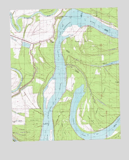
Stubbs Island, MS USGS Topographic Map
Click on map above to begin viewing in our Map Viewer.

This topographic map contains these locations and features:
Feature Name Type Latitude Longitude GNIS ID View Map
Austin BarBarN34.6301°W90.5101°666429View Map
Below Walnut Bend DikesLeveeN34.6793°W90.5790°70032View Map
Blue HoleLakeN34.7182°W90.5774°59556View Map
Blue Point (historical)CapeN34.6737°W90.6193°70033View Map
Blue Point LandingLocaleN34.6720°W90.6243°66419View Map
Bordeaux PointCapeN34.7251°W90.5434°667448View Map
Box LakeLakeN34.6443°W90.6175°59557View Map
Brushy LakeLakeN34.6441°W90.6211°59559View Map
Cannon LakeLakeN34.6620°W90.6043°59560View Map
Cannon LakeLakeN34.6609°W90.5942°74619View Map
Cober LakeLakeN34.6366°W90.6165°65544View Map
Double Bar BendBendN34.7432°W90.6146°48574View Map
Dupuy BarBarN34.7320°W90.5568°684845View Map
Eagle PointCapeN34.7318°W90.6165°48733View Map
Egg BarBarN34.6870°W90.6126°70035View Map
Egg Bar BendBendN34.6873°W90.6132°71539View Map
Forked LakeLakeN34.6338°W90.6129°65543View Map
Grants BendBendN34.7387°W90.6232°49557View Map
Grants LandingLocaleN34.7459°W90.6221°70036View Map
Ground Lump BarBarN34.7445°W90.5798°49692View Map
Halbert PointCapeN34.6401°W90.5762°670891View Map
Harbert LandingPopulated PlaceN34.6537°W90.5573°691920View Map
Harbert PointCapeN34.6532°W90.5782°705667View Map
Hardin Cut-OffChannelN34.7029°W90.5723°77118View Map
Hardin PointCapeN34.6854°W90.5251°81377View Map
Island Number 58IslandN34.6448°W90.5407°82454View Map
Jentry LakeLakeN34.6319°W90.6177°65545View Map
Kate Adams ChuteGutN34.6565°W90.5265°59562View Map
Kate Adams ChuteChannelN34.6501°W90.5684°684853View Map
Lacy LakeLakeN34.6319°W90.6177°65542View Map
Laddie LakeLakeN34.6520°W90.6197°59563View Map
Mound Place LandingLocaleN34.6670°W90.5840°66422View Map
OK BendBendN34.6287°W90.5343°52864View Map
Osborn LandingLocaleN34.7426°W90.6237°70038View Map
Saint Francis Island LandingPopulated PlaceN34.6868°W90.5412°692200View Map
Saint Francis Island LodgeLocaleN34.6859°W90.5412°54326View Map
Sandy BayouGutN34.7212°W90.6093°54565View Map
Sandy Bayou BendBendN34.7462°W90.5932°54569View Map
Shoo Fly BarBarN34.6909°W90.5634°677733View Map
Short BendBendN34.7295°W90.6143°54822View Map
Smith LodgeLocaleN34.6720°W90.5418°54957View Map
Stubbs IslandIslandN34.6668°W90.5584°684874View Map
Stumpy PointCapeN34.6373°W90.6001°55285View Map
Tate LandingLocaleN34.6501°W90.5876°74620View Map
Tate LodgeLocaleN34.6495°W90.5882°55443View Map
Township of HardyCivilN34.6559°W90.6179°66809View Map
Walnut BendBendN34.7312°W90.5645°679295View Map
Walnut Bend RevetLeveeN34.7276°W90.5701°55993View Map
Whitehall CrevasseValleyN34.7423°W90.5637°59582View Map

Note: Coordinates in the location and feature list above are referenced to NAD83 datum.


Copyright (C) 2008-2024 Ryan Niemi / Sunset Dynamics ... All Rights Reserved